
If you are an astronomer, astrophotographer, or even amateur tourist, you have some dreams about long-haul trips for sure. Quite often these trips are such long-range plans, because of our financial situation or spare time available in the foreseeable future. In astronomy or astrophotography, these plans are mostly determined by rare celestial events, which often are confined to specified areas either. The exceptions are typical stargazing trips, aimed at repeatable phenomena, which can be observed at the same or similar time of the year. Nevertheless, for the purpose of our long-pondered journey, we are trying to do our best in the assessment of the weather conditions at the time, when we are willing to spend in our destination area. This article is going to bring you the best way to do these weather assessments, which should help you a lot in picking the best time for your Astro-journey. All the stuff is web-based since the internet is our right hand in any journey preparation. Below you can find the most convenient and well-explained ways to check the weather in your destination area in relation to long-range journey plans.
Frankly speaking, for astronomers nothing is more important than cloud coverage at the potential observation area. Previously I showed you how to deal with the short-term weather forecast, up to 1 week ahead. The long-term weather forecast is something different. It’s difficult to predict the weather for the forthcoming months. Important here is knowledge of the climate of our destination area. This information we can find in any guides or specialist books, but I believe the best way to check it nowadays is the Internet. I will focus mostly on archival and average weather & climate data.
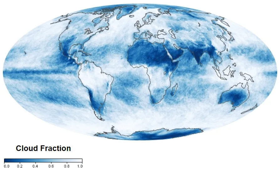
The most comprehensive map of the global cloud cover, highly important for all astronomers is provided by the Climate Reanalyzer service, where you can generate the weather data for one of the longest timespan in recent history. There are several weather factors to select from, but from the astronomical point of view, the most important is the total cloud cover (Pic. 1).
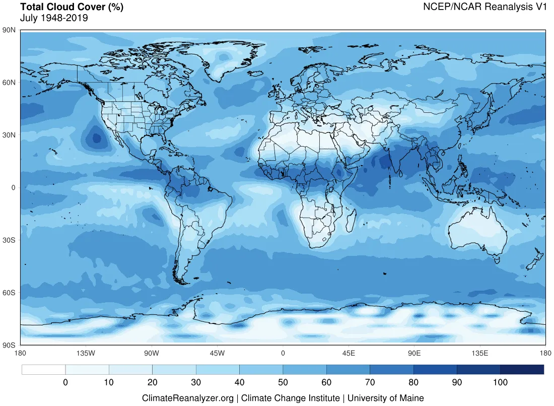
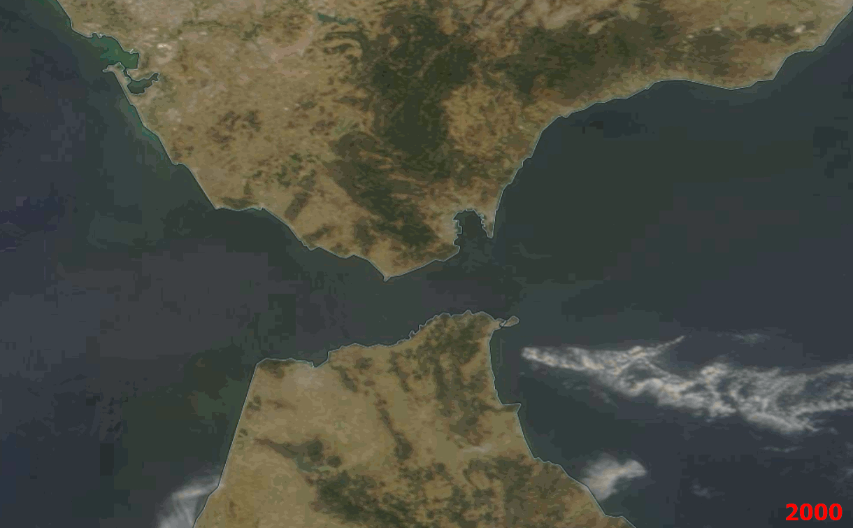
Another very good data was prepared by Jay Anderson, who created them from the NASA Aqua satellite between 2002 and 2015. These maps with 1-degree longitude and 1-degree latitude resolution are detailed enough to show the areas most and less affected by any clouds throughout the year. The images correspond to around 2 p.m. local time (Pic. 2).
On the author’s webpage, you can find these maps relevant for every month, which is really helpful. I would advise you also to visit Xavier Jubier’s eclipse page and download these maps in .kml files.
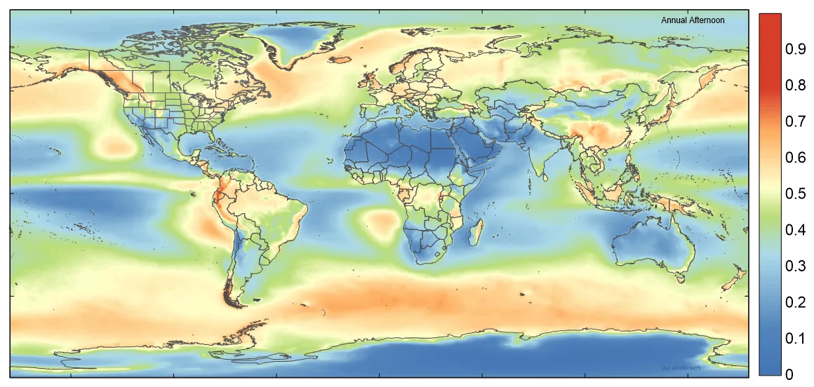
Another good source is the specified NASA server, where you can find the relevant information about i.e. the cloud fraction. You can drag the forward and backward slider, and see how it was in a particular month over the last 20 years (Pic. 3).

Moreover, you can do a selection of the data between the specified timescale (1 day, 8 days, or 1 month) and download it as a JPG, PNG, GeoTiff, or KMZ file, which is brilliant. Staying by the 20-year period it’s worth mentioning the widely available satellite imagery. The best portals, where we can check the cloud coverage on a daily basis from the early 2000s are Zoom.Earth and NASA Worldview.
Looking at it from a different angle we can also be interested in what is the frequency of completely clear sky occurrence in any region. A good place to check it is the Department of Atmospheric Sciences at the University of Washington. They study surface-based cloud climatology and have various land maps regarding this topic. One of the most interesting maps is the frequency of completely clear sky occurrence worldwide both annually and monthly (Pic. 6).
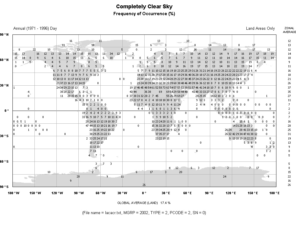
The data comes mostly from the 25-year period between 1971 – 1996 and can be treated as a supplement to the world cloud cover maps presented above (Pic. 1, 2). Obviously, the Department holds the world cloud cover data for the same dates if you are interested in it.
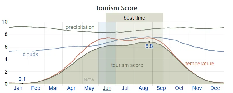
Going out of the overcast, there are also good options to check other weather elements, which can be useful in planning the trip in the future. The best I think is the Weatherspark, which collects all weather data and puts it into one reasonable dashboard. When you enter some city or airport, you can see the brief summary on an annual, monthly, or even daily basis.

All the weather elements comprise the “tourism score”, serving on a yearly basis, which indicates the best period of the year for visiting this place.
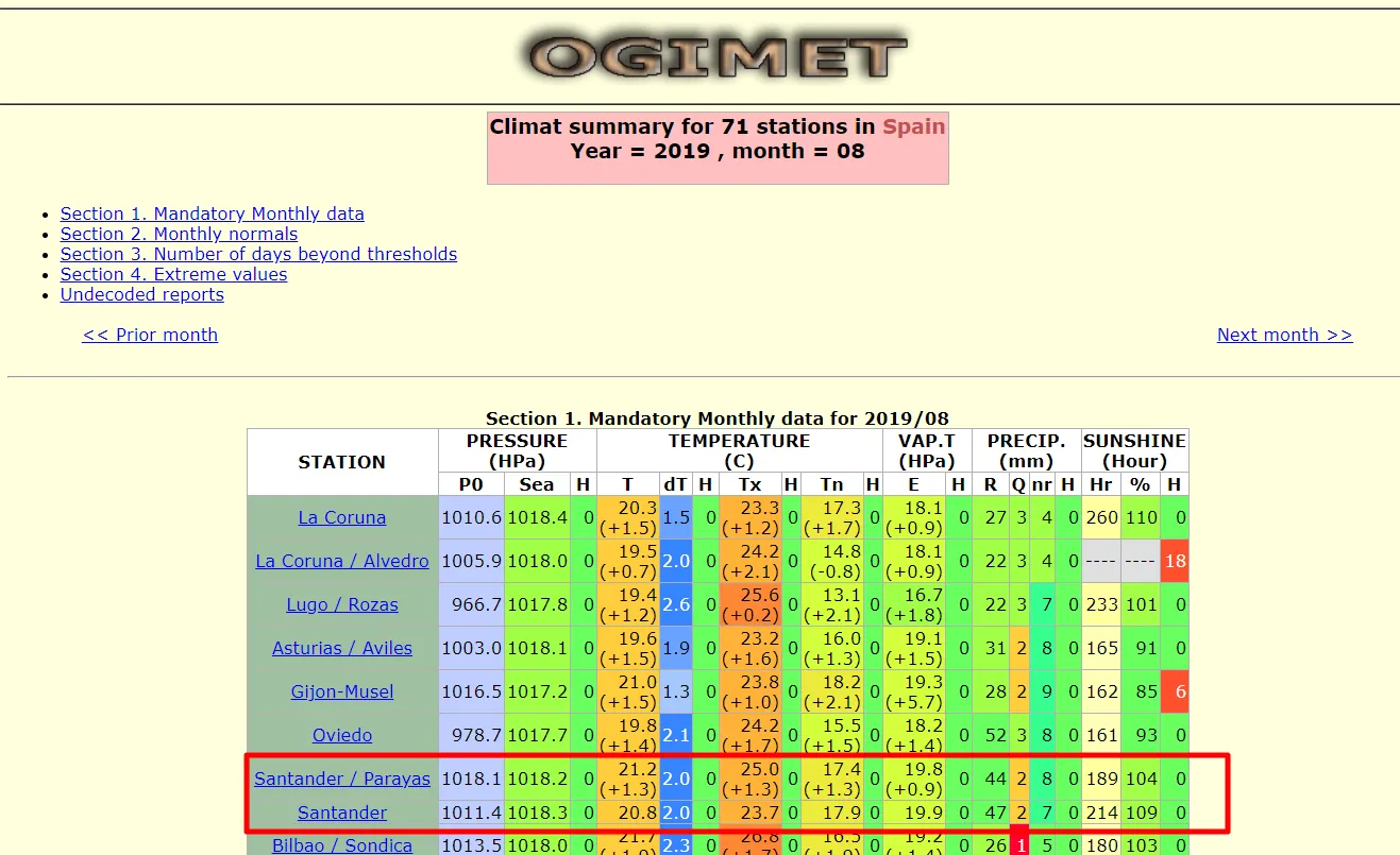
A good source to check past weather conditions is the Ogimet. It’s not as a comfortable platform as the other sources listed above, but it records the weather patterns in detail.
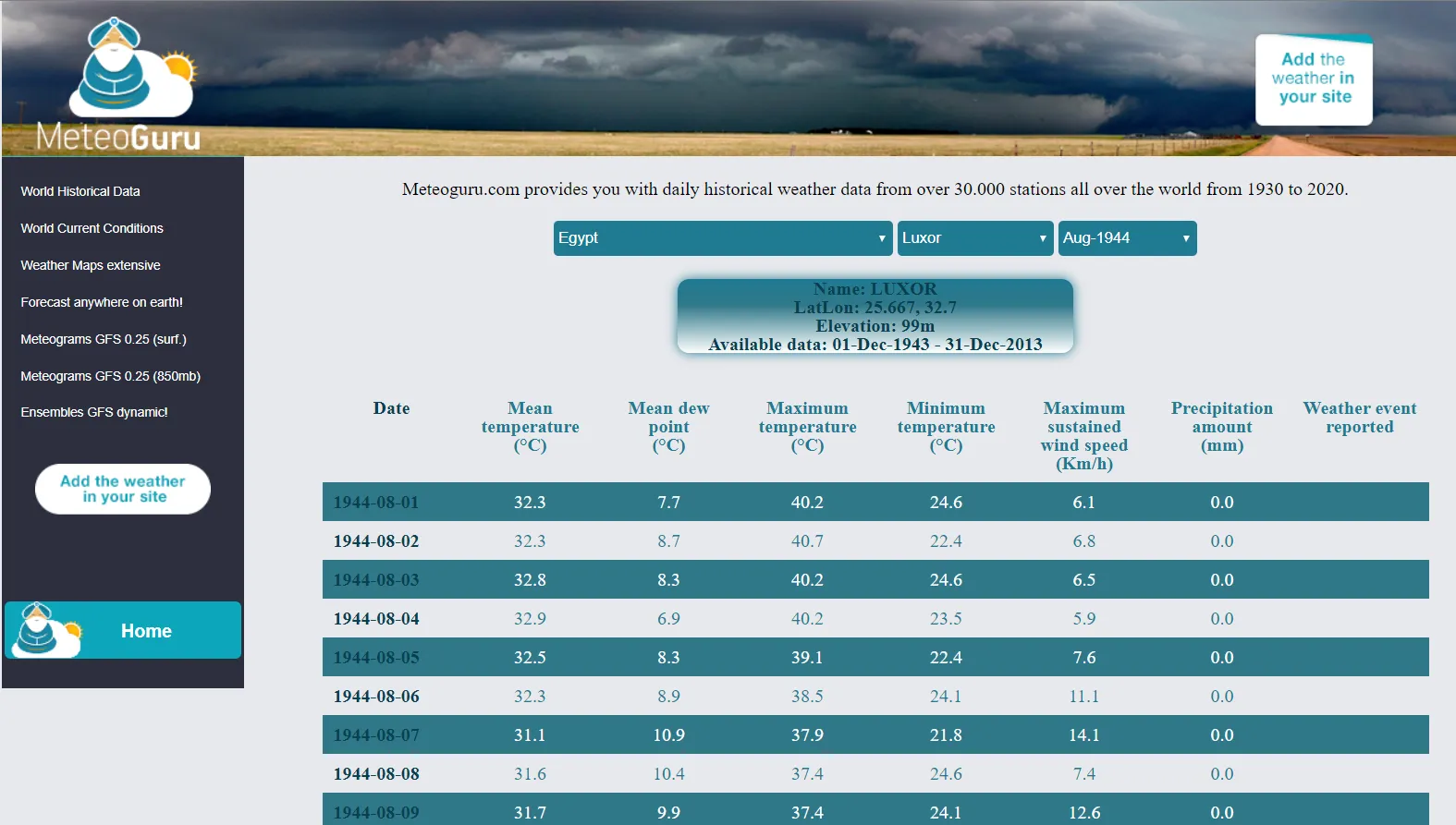
An analog source, where you can get good details of the weather for the given day is Meteoguru.com. The range of historical data can be impressive (Pic. 12), although the interface doesn’t look as good as above.
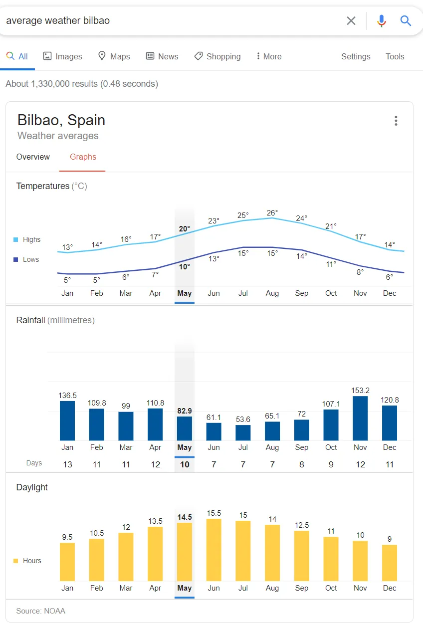
If you need the quickest information regarding the average weather in your destination area, you can also use Google Search, which will show you the data instantly (Pic. 13). Remember, that the instant average weather data in Google is asymmetric between some places worldwide.
You can try to get historical weather data also from other websites, which are:
– wunderground.com,
– climate-data.org,
– weather-and-climate.com,
– climatestotravel.com,
– climatecharts.net,
– worldweather.wmo.int,
– holiday-weather.com.
The portals above are not enough for planning the journey with stargazing in the background.
There are many more servers, copious with climatic data, but this is the discussion for the future. The multitude of these services offers downloadable GIS data, which can be further utilized in many projects. My aim for this article was to show the most convenient and possibly the quickest way to get to know about the weather (especially cloud cover) conditions in the place, where we are heading in the future. This matter is going to be definitely developed in the future.
Mariusz Krukar
Links:
- https://earthobservatory.nasa.gov/images/85843/cloudy-earth
- https://climatereanalyzer.org/reanalysis/monthly_maps/
- Earthobservatory.nasa.gov/global-maps/Cloud fraction
- http://xjubier.free.fr/en/site_pages/SolarEclipseWeather.html
- https://eclipsophile.com/global-cloud-cover/
- https://zoom.earth/
- https://worldview.earthdata.nasa.gov/
- https://atmos.uw.edu/CloudMap/index.html
- https://weatherspark.com/
- https://www.meteoguru.com/
- https://gisgeography.com/free-world-climate-data-sources/
- https://www.wunderground.com/history
- https://en.climate-data.org/
- https://weather-and-climate.com/
- https://www.climatestotravel.com/
- https://climatecharts.net/
Forums:
- https://www.researchgate.net/post/What_is_the_best_data_center_to_download_world_climatic_data
- https://www.researchgate.net/post/Is_there_any_website_offering_historical_meteorological_data
- https://opendata.stackexchange.com/questions/2009/historical-weather-forecasts
Wiki:
Read also: