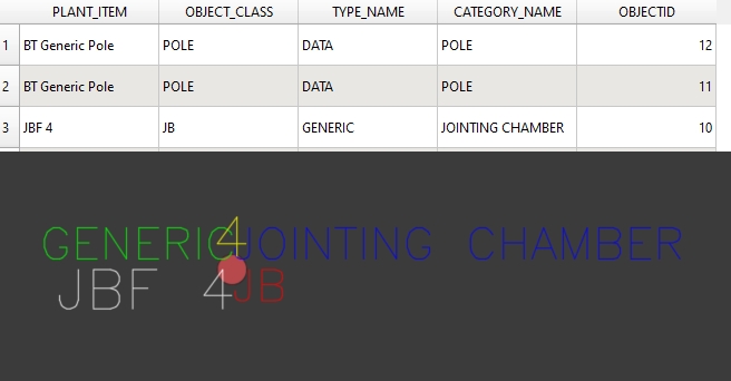
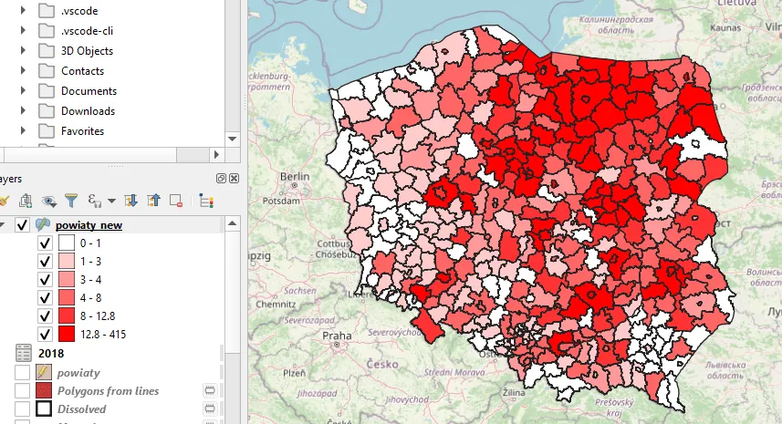
Author: Krukarius

Downloading OpenStreetMap vector datasets effectively

OpenStreetMap platform is a worldwide free geographic database, updated and maintained by free volunteers. The primary advantage of this platform is the availability of the data, which can be downloaded anytime by the user...

Using special characters in QGIS expressions

This brief text explains how to use some custom symbols in QGIS expression. Obviously, it applies only to the quoted part, which represents the bits with string. There are 2 ways of doing it....

Effective geocoding in Python free of charge

In this short text, I would like to share my approach regarding the simple Python geocoding tool. This tool is completely free and I’ve implemented some elements for its usability, which should make it...

What exactly is a hybrid solar eclipse?

This text is aimed at explaining to you what roughly is the hybrid solar eclipse phenomenon. In my opinion, most sources define the hybrid solar eclipse incorrectly, defining it as the eclipse, in which...

Folium Draw plugin – extended functionality

The Draw is a very nice plugin dedicated to anyone who wishes to draw editable vectors on the Folium map. It’s a comprehensive plugin, that can add lines, polylines, polygons, rectangles, circles, circlemarkers, and...

Styling on-click marker on Python Folium map

Recently I’ve explained to you how to launch Google Street View from any place on the Folium map. Today it’s the time for continuation – styling the on-click marker, which can be applied to...

Happy New Year 2023 to everyone!

Another year is over. Traditionally it’s time for new wishes for everyone. On this occasion, I used to attach some pictures of fireworks watched at particular places or even a multitude of random spots...

Opening Street View with Python Folium map

Folium is a powerful Python library dedicated to geospatial data visualization. Its major engine is based on Leaflet – an open-source JavaScript library for mobile-friendly interactive maps. There are a lot of sources on...

Breaking down the Street View permalink

Google Street View is a technology, which provides interactive and multiperspective panoramas of many places and streets worldwide. It’s commonly used on a daily basis, but hardly anyone pays attention to the permalink displayed...

AutoCAD LT – Zoom (search) by coordinates

I would like to show you a nice feature in this short article.  You can use it in your AutoCAD software and the LT version. It applies to searching (or zooming) the object by...