
Long distance observations – definition & types
This article is about the general definition of the realm, which has been described occasionally on this website since 2017. Therefore I guess I should have done it much earlier, however better late than never. Anyhow today I would like to focus exactly on both the primary definition as well as the basic divisions of long-distance observations keeping in mind the fact, that this thing hasn’t been precise so far in the universal sense.
1. THE DEFINITION OF LONG-DISTANCE OBSERVATIONS
Long-distance observation is any visual observation whether, for sightseeing or photography, that focuses on all the inanimate and solid objects that are visible from the farthest distance with the possibility to see them close by the observer or recording device.
With respect to this definition, long-distance observations cannot include:
-> Celestial objects – which with assumption are always far away from an observer and are a subject of astrophotography.
-> Satellite Watching – which is concentrated on spotting or tracking artificial objects orbiting Earth and suspended at significant altitudes far outside of the Earth’s atmosphere.
-> Aircraft Spotting – referring mostly to the aircraft observed in the vicinity of the airport only or near-zenith section of the sky. In practice, the observation of an airplane passing (transmitting) the lunar or solar disk cannot be classified as a long-distance observation either. This is the situation, where planespotting coincides with astrophotography. The exception to this rule occurs when we consider the circumstances beyond the 1st and before 4th contact with the horizon. The plane at this angular altitude above the ground is hardly detectable by the observer on the other way. The second reason behind it is, that these moments indicate the sunrise/sunset in the geometrical sense where the solar disk disappears or reappears behind a particular distant horizon feature.
The long-distance observation is also not:
-> any type of cloud, as clouds are the components of the weather defining the conditions of the long-distance observations itself.
-> contrail, except for its direct contact with the aircraft engine, which in fact indicates the current position of the plane in a distance (Pic. 1).
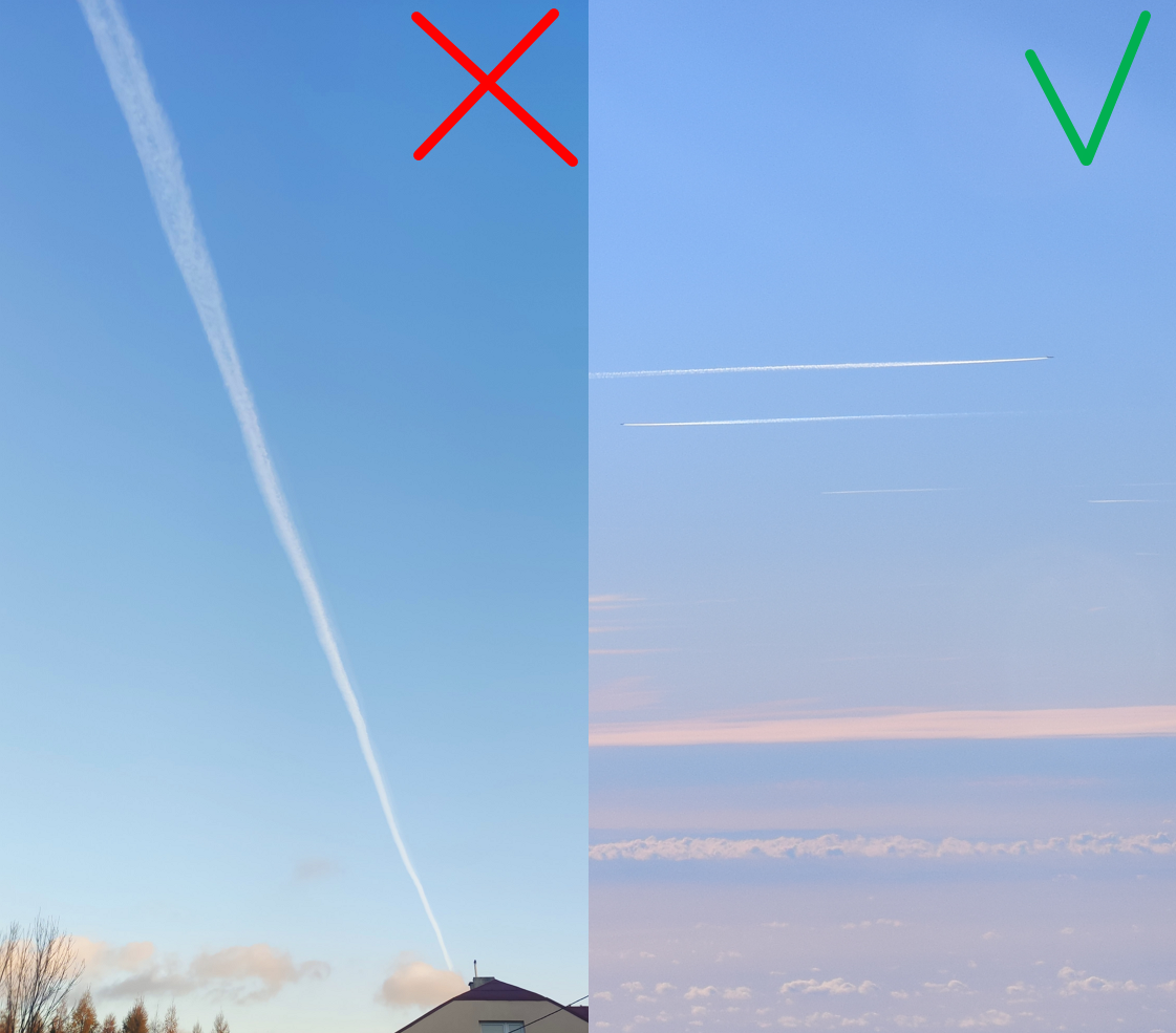
Pic. 1 The appearance of contrails against long-distance observations.
-> shadows of distant mountains, because their presence is driven by the current situation in the atmosphere (the degree of atmospheric clarity or lack of clouds),
-> animal called also wildlife spotting. This is an example of an animate object, whose behavior, as well as the direction of movement, is mostly undefined unlike i.e. the plane or balloon,
-> condensation cloud (Wilson cloud), which is a result of a sudden large explosion of humid air and usually has a transient character,
-> city light glow or other forms of urban light pollution observed from often visible well when reflected from cloud deck or thick haze layer.
-> condensation puff-looking smoke produced by industrial objects because usually it constitutes the building accumulation for the lowest cloud deck or haze within the planetary boundary layer.
-> significant puff of smoke produced by i.e. warfare or wildfires. It’s the element, which shapes the local conditions of long-distance observations by the impact on atmosphere clarity in the local area.
The long-distance observations in a limited sense can be:
-> rockets launched as a part of some cosmic mission (Pic. 2) – just within the lower atmosphere limits, which are discussed later in this article.
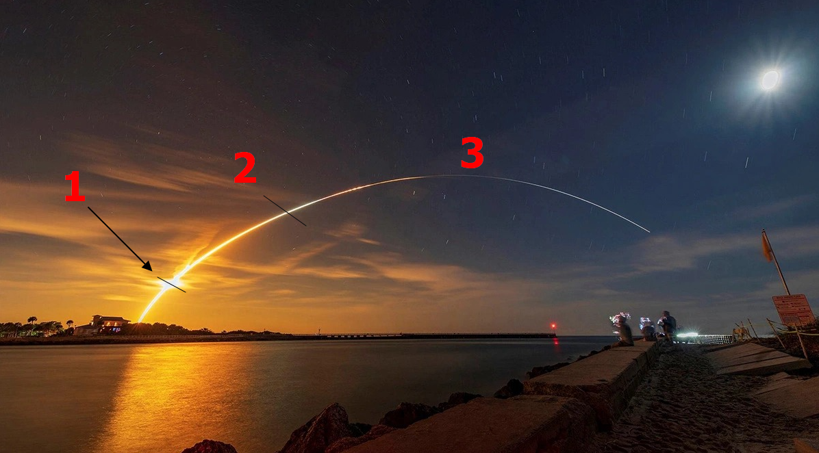
Pic. 2 The rocket was launched as the NASA Artemis mission and seen from Sebastian town at a distance of about 75km in a beeline, where: 1 – assumed upper troposphere limit; 2 – assumed upper limit of long-distance observations; 3 – the climbing up rocket is the subject of astrophotography even if still remains within the Earth’s atmosphere (Joe Rimkus Jr./Reuters).
2. TYPES OF LONG-DISTANCE OBSERVATIONS
A. Ground-to-ground – they cover the widely-understood landscape of Earth, which is comprised of not only the natural features but also all the man-made objects firmly integrated with the Earth’s surface.
The natural features can be:
-> mountain ranges
-> isolated peaks or hills
-> vegetation (while freestanding trees)
The artificial objects can be:
-> Dumps or opencast mines (created by terrain transformation)
-> TV or telecom transmitters
-> Chimney power plants
-> Skyline (understood as the city’s overall structure, which “meets” the sky), which includes high-rise buildings or towers.
At former times, observations such as these could be reported just visually, which resulted in usually written reports, paintings, or sketch images, invoked later by some chroniclers. Nowadays, the primary source of reporting the result of the observation is any type of image-recording device, which makes undeniable proof, that the given observation took place. In fact, for the ground-based type of observations, we can use the following examples of camera-like devices:
-> DSLR or compact digital camera
-> camcorder or video recorder
-> smartphone camera
-> webcam, which features a decent-quality streamed image. By the decent quality, we can understand the resolution and appropriate contrast sensitivity (dynamic range), where the distant horizon in the frame is visible clearly enough to distinguish the remote features under favorable conditions (Pic. 3)
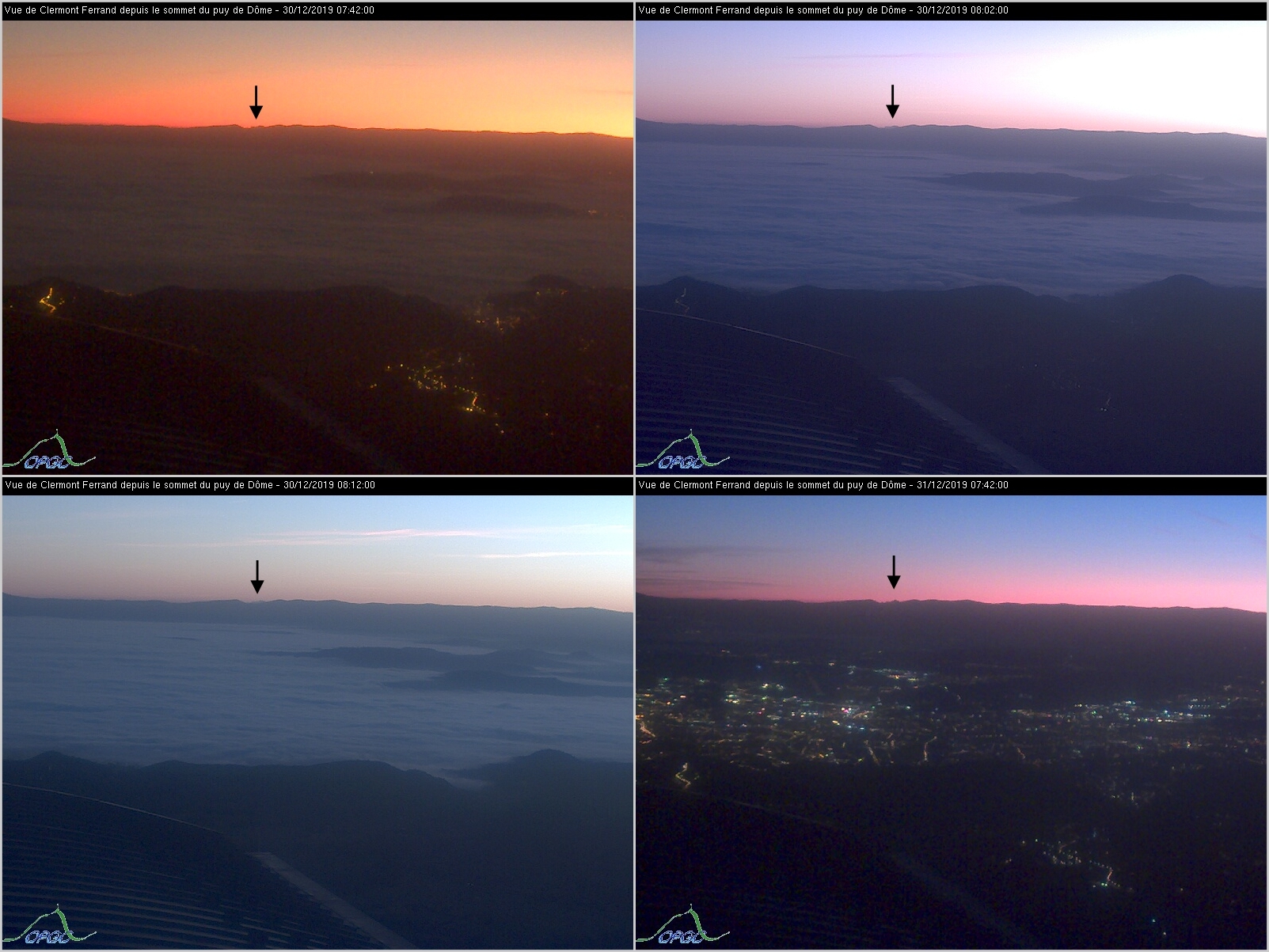
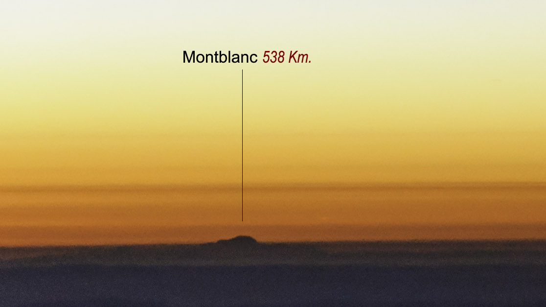
Pic. 3 The Mt Blanc (indicated by black arrow) is visible from the webcam located at the Puy de Dome summit at a distance of 303km (500-mm.blogspot.com|http://www.obs.univ-bpclermont.fr/
-> drone – just in the following situations.
A. When the equipment sits on the object firmly integrated with the ground only in the case when access by the observer is extremely limited, too dangerous, or impossible. In fact, an observer must be topographically in the same location where the drone has been placed. In another case, the drone image shall be classified as aerial long-distance observation.
B. When the device is suspended in the air, just within the obstacle detection area. This area could be defined within the distance to the object adequate to spreading arms by an adult person (arm span). It’s essential due to the parallax reason. Capturing an image too far from an object will make this observation unreliable. For best proof, an operator should provide another image captured toward the very nearest obstacle. Moreover, an operator should capture himself standing right below the device.
C. When the altitude of the apparatus is not higher than the total length of the building or construction, assuming, that the situation described in point B is in use (Pic. 5). Otherwise the observation type should be classified as aerial.

Pic. 4 The way of using drones should be treated in distinguishing the types of long-distance observations (pink dotted line) with comparison to the situation, where the presence of an observer is possible at the given object. When the ground is free of any objects, the boundary between ground-based and long-distance aerial observations almost coincides in both cases. The physical presence of an observer shall be treated as the view from the level of human sight marked as the dark blue dotted line (A), the drone usage shall pull this line slightly up to the top of the human’s head (Ca), which eventually makes almost no difference. The situation changes for any object firmly integrated with the ground. The exception here might be just a tree, where quite seldom an observer can reach its very top (Ba), therefore the observer in place will see the distant feature from a lower position (marked by a light blue dotted line). In another case (Bb) an observer by standing on the very top of the building can get a higher view (light blue dotted line) than assumed for drone allowance by gaining its own height up to the level of sight. The last example (Bc) refers to the situation, where some observers could reach the highest level of some tower, but in reality, it’s still something missing at the very top. All the cases (Ba, Bb, Bc) apply to the situation only when access is at some point possible. The ground-to-ground long-distance views can be applied in general in the case when the drone doesn’t cross the pink line defined by both the built-in obstacle detection alert and the arm span (Cb), as shown in the image above. The boundary between ground-based and aerial perspective here is the geometrical middle of the drone flying strictly along this pink line, which in some cases can pass the obstacles also from the top (Cc) in a distance of standard human height as considered for the ground (Ca) only when the given object has some isolated higher elements (like a chimney, antennas, etc). If this is so, the boundary should firmly stick to the very top of that object or its element (Cd), on which potentially the drone can sit for a while.
The key criterion of ground-based long-distance observations is the location of the observer or device must be on the ground or stick to the object integrated with the ground. The same role applies to an observed item.
Ground-to-ground types of long-distance observations are limited due to Earth’s curvature. Nowadays, the upper limit is marked by the longest sightline of Earth described in many sources, although a further explanation of these details will be done here.
Despite the limitations described by their upper limit mentioned above, the ground-to-ground type of long-distance observation is the most important from the human point of view, marking the integrity with the surface as the primary, and transparently defined criterion. That’s why a vast majority of the articles in my website refer to this specific type of long-distance observation. All objects unified with the ground can increase the visibility cloak from the given place. They shouldn’t be neglected, because in most cases someone must have stood on top yet at the construction steps. That’s why drone images are allowed in this roughly limited sense.
Some specific groups treat ground-based long-distance observation as a sport, in which both the observer as well as the observed object must be integrated with the ground (Krukar, 2020). It means, that apart from the criteria described above, the presence of an observer in the observation venue and capturing images just from the level of human sight is the primary key. This leads to the exclusion of drones and webcams completely. Treading their way, more legitimate would be to allow to make the observations just on the places accessible at some point by the public. It will be good to describe these internal norms in the future, which In my point of view should fall inside the general criteria of the ground-to-ground long-distance observations.
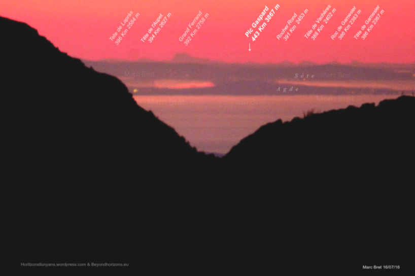
Pic. 5 The World record of the ground-to-ground line of sight captured – 443km. The view at the Massif de Ecrins from the Pyrenees (M.Bret/Beyondrange.wordpress.com).
B. Ground-to-air – refers to the situation, where an observer standing on the ground or another object unified with the ground is able to observe the objects visible within the lower parts of the Earth’s atmosphere.
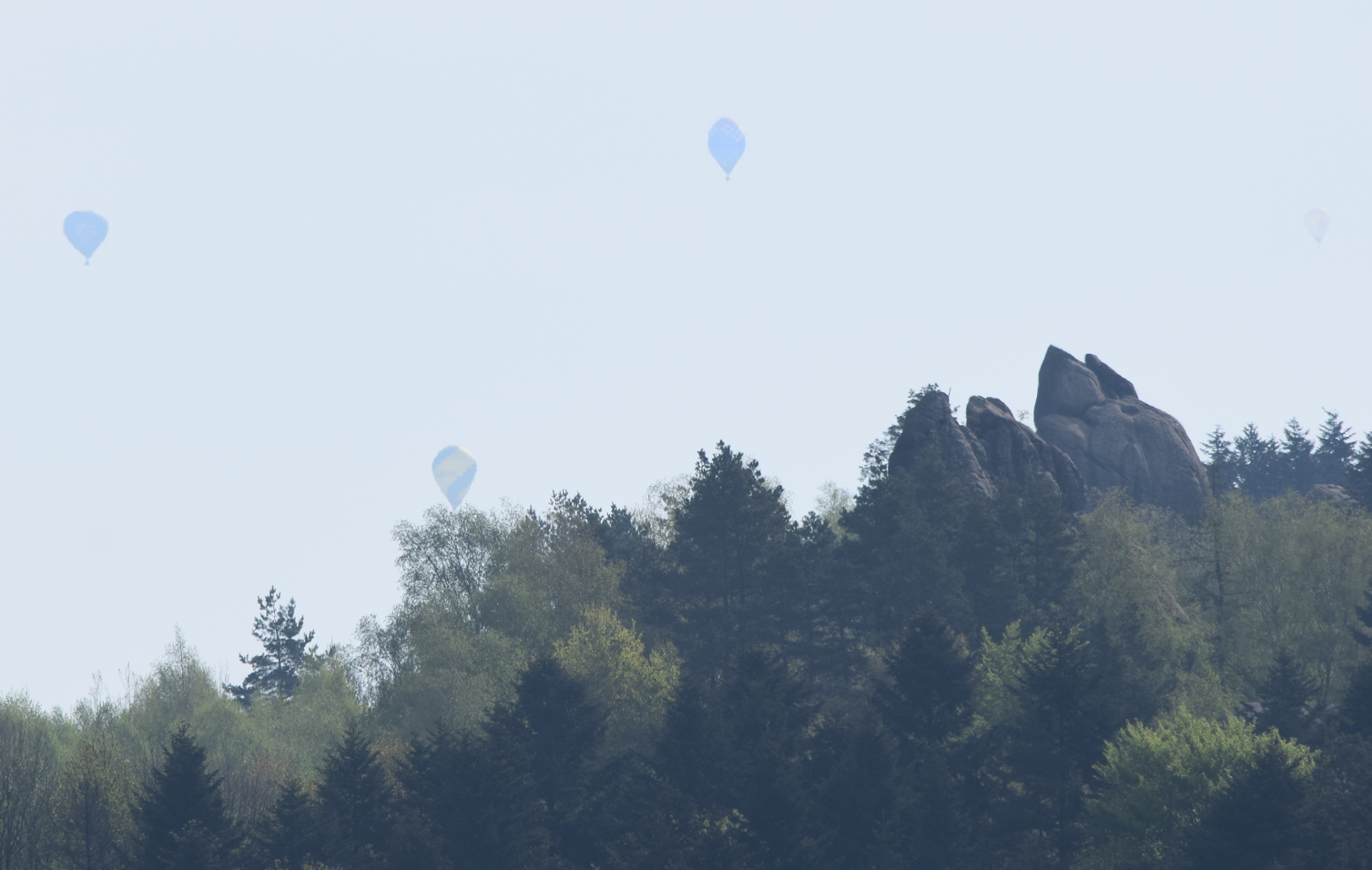
Pic. 6 An example of ground-to-air long-distance observation. The subject of watching is a flying balloon at an estimated distance of 10km from the observer. Korczyna, Subcarpathian, Poland. Image cropped.
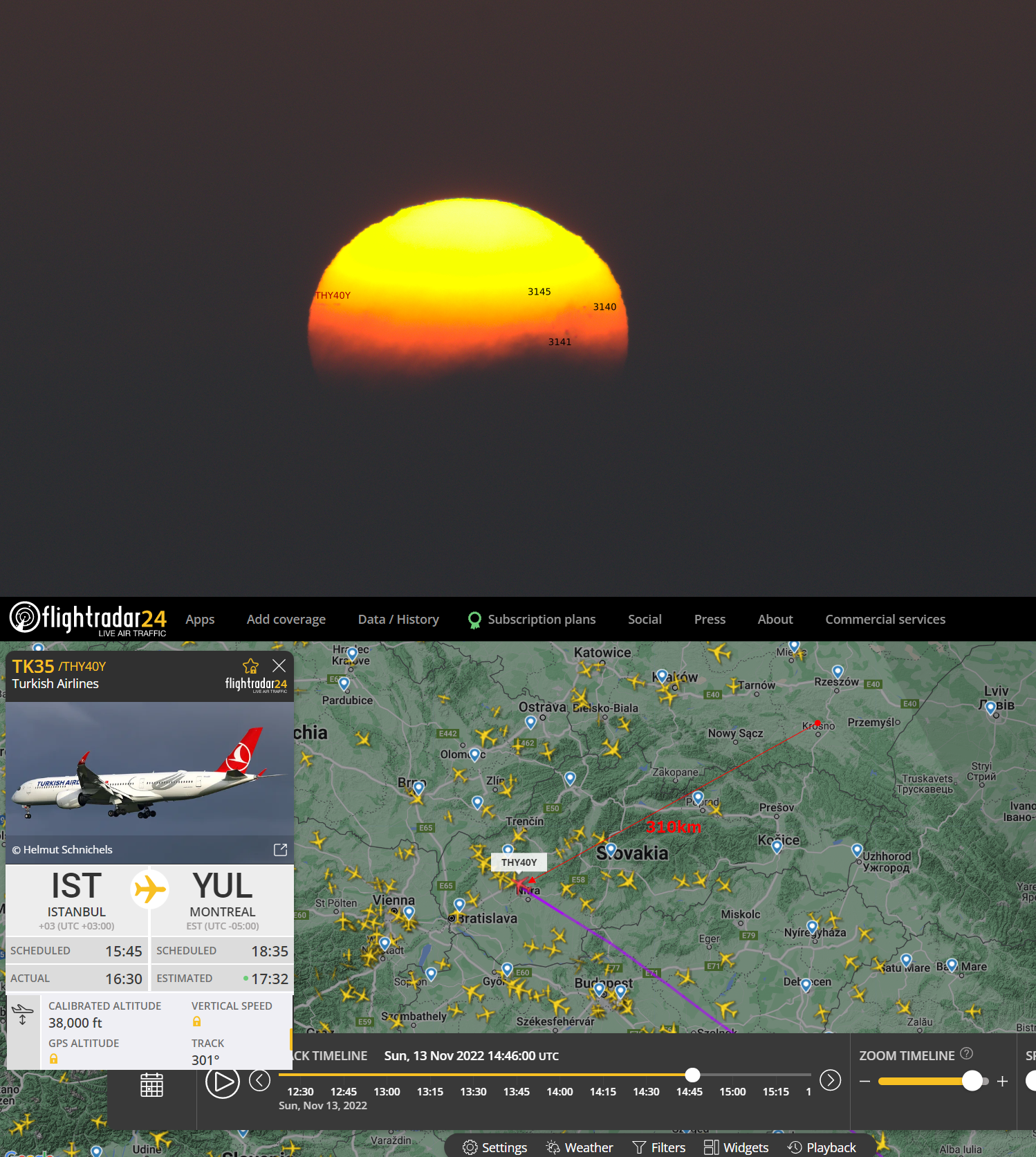
Pic. 7 Turkish Airlines on the way from Istanbul (IST) to Montreal (YUL) passing above Nitra region (Slovakia) captured when crossing the Sunset observed from Rzepnik (Subcarpathia, Poland) at an approximate distance of 310km when crossing the solar disk. The sunset was behind the Tatra Mts ridge not visible because of the stratus. The flight circumstances correspond to the time when the image was taken. As per Peakfinder.org, the Sun was already after 1st contact with the horizon.
C. Aerial – applies to the situation, where an observer or the device used isn’t integrated with the ground or at least with an object directly sticking to the ground at the moment of the observation. The aerial type of long-distance observation targets usually objects located on the ground and integrated with it. In fact, the specificity of this type of observation becomes different as the altitude of the observation increases. The primary reason behind it is an increasing reduction of contrast between the distant horizon and the sky. As a result, at altitudes greater than a few kilometers the horizon becomes indistinct (Bohren, Fraser, 1986) despite it being almost as sharp as the sea-level horizon (Lynch, 2008). This is because the Rayleigh scattering and scattering of aerosols reduce this contrast. Other factors, which could be claimed here are a contrast reversal between the distant horizon and sky and decreasing scattering coefficient. Technically an observer cannot see objects at a distance of further than several hundred kilometers unless we deal with brightly sunlit objects, which may lead to large ranges (Dietze, 1957).
Pic. 8 The primary targets of the aerial long-distance observations are ground features, which can be captured from a distance of hundreds of km. Mt. Blanc as seen above the top of the cloud deck before sunrise. The image was taken above Bordeaux. Flight number and altitude unfortunately unconfirmed (Ramon Ibarz/Beyondrange.wordpress.com).
The specific brand of aerial long-distance observations could be air-to-air perception. Conversely to the ground-to-ground type, the observer can view the objects that are already situated in the air (Pic. 9).
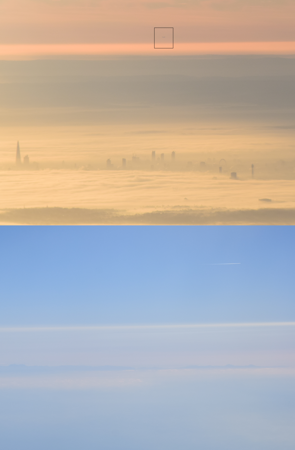
Pic. 9 Examples of the air-to-air type of long-distance observations, where the subject of observation is the plane as seen from another plane. The distance is about 50km (upper image) where the plane is attending to land near London and about 100km (lower image) where another plane is flying above the Sierra de Tramuntana at Mallorca.
It’s very important to define how the biggest altitude shall be considered for aerial long-distance observations. We can assume two sensible altitudes here. The first one will be cruising altitude, and the second one – is the upper ozonosphere layer. Why these? Carry on reading below in section 5.
Excluding the density of Earth’s atmosphere, we shall assume the maximum possible view between two objects situated at the same, maximum possible altitude of 40000m would be according to the following formula below:
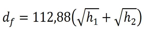
where:

df - final distance
112.88 - the distance of horizon in kilometers at altitude of 1 km when refraction neglected
h1 - altitude of the observation place
h2 - altitudde of observed object
giving the final value of about 1428km when atmospheric refraction is neglected, and by using the alteration of the formula below:
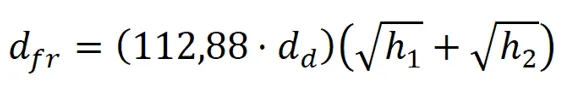
where:

dfr - final distance (including refraction with standard coefficient as k=0.13)
dd - difference between distances calculated with and without the standard refraction coefficient, which counds exactly 1.072.
112.88 - the distance of horizon in kilometers at altitude of 1 km when refraction neglected
h1 - altitude of the observation place
h2 - altitudde of observed object
The absolute extremal distance would be at most 1530km for a standard refraction coefficient of k=0.13 (Pic. 10).

Pic. 10 The way of long-distance observations should be perceived at least in the case of Earth, where: A – pink dotted line marking the ground-to-ground lines of sight falling always inside of the troposphere layer (1). The troposphere layer often coincides with commercial plane cruising altitude. However, the absolute limit of the aerial long-distance observations should occur at an altitude of about 40km (B), which coincides with the upper ozonosphere (2). The reason behind it is the Belt of Venus behavior, which marks a quite sharp boundary between the illuminated and shaded atmosphere of Earth (explained later in this article). The extremely low density of the upper Earth’s atmosphere excludes any visibility deterioration and light attenuation caused by air molecules above the blue dotted line (B). Because the optical conditions there are very similar to the interplanetary vacuum, this whole area should be only a subject of astrophotography despite the Karman Line (C) placed further above.
Considering just ground-based objects, the maximum achievable distance from this altitude could reach as much as 1144km in the case of Mt. Everest. We obviously assume the standard refraction coefficient k=0.13, which can be lower accordingly at altitudes such as these. It also will be the subject of concern for further writing here.
Conversely, taking into account just the upper troposphere, or at least commercial plane, these distances are accordingly smaller. To be honest it’s better to place them in the table below:
The aerial long-distance observation can be made from:
-> balloon
-> meteorological balloon – assuming, that all the circumstances of the flight are commonly known (especially altitude and time)
-> drone
-> plane – where additional criteria shall be applied. In order to prove the long-distance aerial observation, the observer must provide both the details of his picture (especially the date and some EXIF, like lens used) as well as detailed circumstances of the flight indicating the moment when the image was taken (by correlation i.e. with the time of capturing your image). You can use the Playback option in the flightradar24.com service, which gives you a detailed view of worldwide up to 7 days back in the free version (Pic. 11).
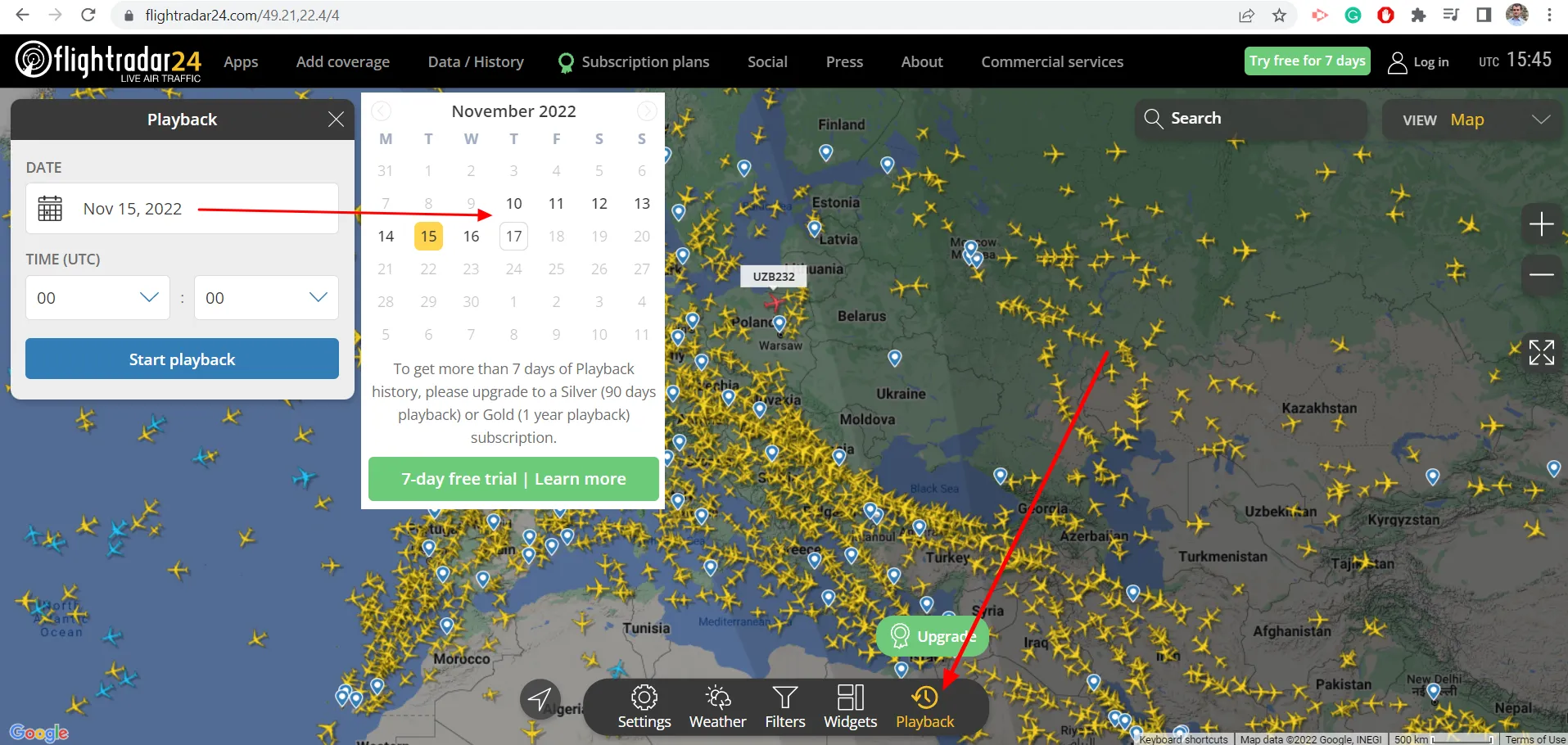
Pic. 11 The playback option in Flightradar24.com service.
You should know the basic details of your flight and find the plane easily. When you do so, compare the flightradar24.com map i.e. with Google Maps, where you can measure the distance easily between the estimated position of your plane and the observed object.
This rule should apply to all planes and other objects detectable by the flightradar24.com service.

Pic. 12 Identification of the flight in Flightradar24.com, where: 1 – Important flight circumstances to record; A – Flight number; B – Cruising altitude; C – Time (exactly the same when your image was taken); 2 – Identification of the location of an estimated distance; I – Close-up the flightradar24.com map with the position of your aircraft; II – The “Measure distance” option in Google Maps indicating the estimated aircraft position.
– other vehicles (i.e. ultralight trike, helicopter),
– parachute
3. THE AESTHETIC BACKGROUND OF LONG-DISTANCE OBSERVATIONS
Theoretically, the visual range is defined as the maximum distance a black object can be seen against the background sky (Vollmer, 2020). In fact, any successful observation of the object, which can be even barely distinguished from the background can be marked as the visual range, that has been captured. However, seeing just silhouettes of distant features might be not always enough from an aesthetic point of view. Therefore I could propose the types of long-distance observations based on their visibility.
A. Visible – whose primary key is just to spot the object even if its contrast barely varies from the background beyond. An observation such as this brings proof, that the object can be physically visible from the given venue. The primary appliance of this kind of observation could be a detailed study of terrestrial refraction.
B. Detailed – where apart from the physical presence of the distant object, an observer is capable of distinguishing some details like snow-capped places, forested sections of the given mountain, crags, etc. A view such as this could be a perfect measurement of the degree of atmospheric clarity.
C. Clear – means the best quality of long-distance observation, which results should be capturing the distant object on which everything can be clearly readable. It’s really hard due to the dynamic of the air, which especially under sunlight or windy conditions tends to distort image sharpness (heat haze phenomenon). The degree of distortion could be measured by capturing narrow-angle objects like transmitters, whose fuzziness should be similar regardless of the photo lens applied. The appliance of this kind of long-distance observation could be in the measurement of lower atmosphere turbulences.
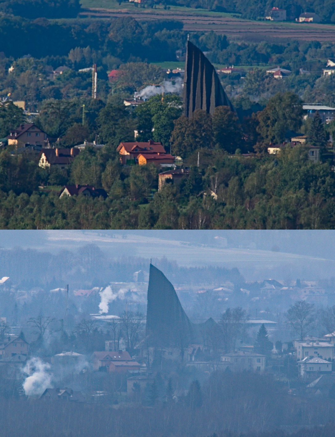
Pic. 13 Two aesthetic types of long-distance observations. The upper image despite perfect clarity suffers from serious atmosphere turbulence, which makes the view fuzzy blocking some smallish landscape details, which are better visible in the bottom image. On the contrary, the second one is less clear due to the mist, where the colors of features aren’t expressed nicely. View at Andrzej Bobola’s church in Potok village at a distance of 5,8km (Subcarpathia, Poland).
4. EXTRATERRESTRIAL LONG-DISTANCE OBSERVATIONS
The biggest number of pictures from the planet other than Earth comes undeniably from Mars. Over the decades, as the land rovers penetrated the Martian surface, they took a multitude of various images whereby some of which display what is happening at the horizon. An example of an image such as this we can see below (Pic. 14).
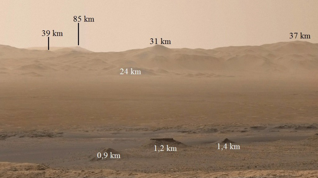
Pic. 14 An example of long-distance observations on Mars – image was taken by Curiosity on the 1850th day of the mission (19.10.2017). Distances provided by Rancor/Wykop.pl. Credits: Unmannedspaceflight.com/ NASA.
The image has distances provided by using the orbital imagery from Google Mars. The specificity of defining them in an environment free of any reference points like trees or buildings can be quite tricky. Despite quite small distances, the panorama above looks very interesting. Remember, that the Martian radius is just 3390km compared to 6371km in the case of the Earth. Thus all these distances shown could be almost multiplied in earthly conditions.
5. THE AMBIGUITY OF SOME CRITERIA
Provided division of the long-distance observations is as best as possible at the current moment. However, there are some bits, which require further authentication. It will be surely provided along with the next articles, but now we need to take a look at the threads, which remain at some point unclear.
A. Condensation puff-looing smoke – which is an inherent element of the industrial object. By default, it shouldn’t be considered the subject of any type of long-distance observation, because it causes a serious deterioration of atmosphere clarity in the local sense. In truth, we could dispute with respect to the theoretical maximum height, at which this element of landscape could fall under long-distance observation. It would be applied strictly just for the situation when the condensation smoke makes a continuous visual impact on the local landscape on a regular basis instead of being just a single short-term event once in a while. Any type of aerial approach will eventually result in seeing the source of this smoke (for example chimney) directly, therefore this type of sight can’t be classified this way. On the other hand, when the puff of smoke is quite far beyond the horizon it usually doesn’t remain a consistent element but rather a bit of cloud. In an event such as this, it should be treated in the same way as the clouds are.
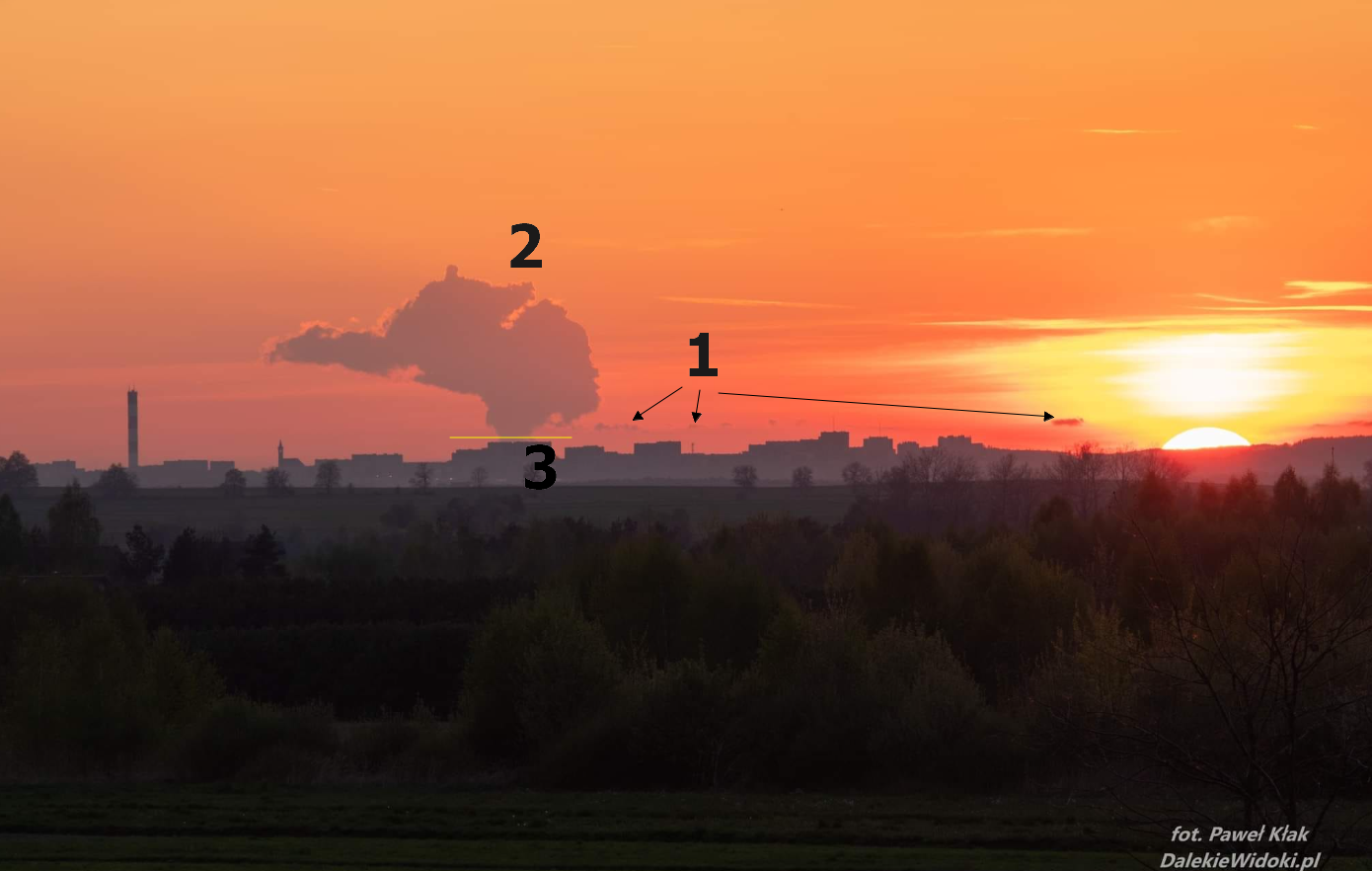
Pic. 15 The example of robust condensation clouds produced by the Belchatów power plant located about 120km from the observation place (Skorzeszyce near Kielce, Swietokrzyskie, Poland), where the condensation puff-looking smoke has interacted with the cloud deck and accumulated at high altitudes. The cumulus layer can be seen just above the horizon (1), therefore the whole shape visible above (2) cannot fall under long-distance observation. At most, the yellow line (3) can be considered as the limitation here, below which the condensation product could have been treated as the long-distance observation under the restrictions described above (Paweł Kłak/Dalekiewidoki.pl).
On the other hand, looking at the image above, we can be convinced that a vast majority of these condensation clouds would be excluded, as they very often reach the cloud deck or air condensation area or at least turn into a layered haze. In a case such as this, it’s not the object of long-distance observation anymore.
B. Webcams – they can be your right hand in ground-based long-distance observation. The primary downside here is, that there is no web camera, which would be better than a DSLR in quality. Truth be told, an exception could be assigned for the Foto-webcam.eu German provider, which offers webcam shots up to 5Mpix. Even so, the observer usually attends with the telephoto lens, which is rarely met in the webcam environment. On the other hand, wherever a webcam is capable of capturing long-distance sight it’s always valuable from a scientific point of view.
C. Upper boundary of long-distance observations – it seems to be the most complicated conundrum by now. In my point of view, just two boundaries should be considered. The first one could be most reasonable, as it refers to the boundary of the upper troposphere at about 10km above ground on average. It coincides with cruising altitude. The primary reason for picking it up is, that only in the troposphere up to 4/5 meteorological phenomena take place, including also cloud development. Even if you are flying by plane at quite a high altitude within the troposphere you can witness very similar conditions for long-distance observations as discussed in the case of ground-based approaches.
Another boundary, which could be applied will occur at the altitude from which the daylight sky appears to look completely black at the zenith. This is one regularity, which could be applied here. It’s worth analyzing the Belt of Venus’s appearance, called also the antitwilight arch, which is a part of the twilight wedge. When an observer takes a look at the moments, when this phenomenon occurs, they will surely convince, that it applies to the moment shortly before sunrise and after sunset. Truth be told the antitwilight arch is best visible just at the beginning of the civil twilight, because of the sunlight passing longer way through the atmosphere. In turn, the sunlight is strongly reddened due to long wavelengths scattering. Important is another matter. As the observer follows the Belt of Venus it crosses the sky quickly as the Sun plunges deeper under the horizon. On the other hand, the phenomenon fades away itself, although the shadow of Earth following it remains clearly visible dividing the sky on the brighter and darker side. For the upper boundary of the long-distance observations, the crucial moment is when the sky is divided in half between the illuminated and shaded sections. It marks the time when the former antitwilight arch (rather barely visible now) crosses the zenith. When exactly does it happen? It’s at the very end of civil twilight when the Sun is exactly 6º below the horizon. Having this knowledge, we can use the proper computations to define at what exact altitude the following phenomenon takes place.
For this purpose the essential step will be the application of the dip of the horizon formula, which looks as below:
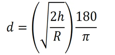
where:

d - the final value of horizon dip at the given altitude
h - the altitude of observator
R - the main radius of Earth (flattening neglected)
and returns the value in radians, but because it’s good to have it in degrees, we should do the conversion between radians and degrees expressed by 180/Π.
The above formula omits refraction, giving the value of dip of the horizon equal to 6° at an altitude of 35km above the ground.
Because the deviation of light in the atmosphere is inevitable, we should consider at least the standard refraction coefficient k = 0.13 and the final formula will look as follows:
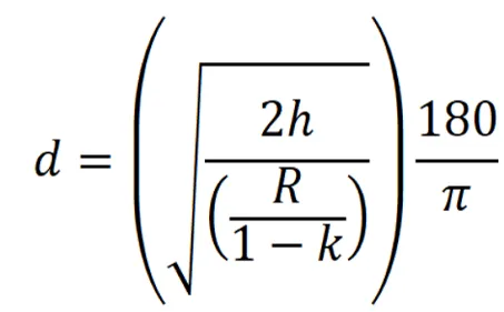
where:

d - the final value of the horizon dip at the given altitude
h - the altitude of the observer
R - the main radius of Earth (flattening neglected)
k - standard atmospheric refraction coefficient
and again, the final value is thrown in radians, which can be converted to degrees easily by applying the equation below.
d(rad)* (180/Π)
Under the standard refraction coefficient, the difference in altitude is significant. The final altitude of the observation point must be lifted up to 40153m.a.g.l, which can be rounded to 40km above ground for the sake of simplification.
The altitude of 40km above ground would correspond to the position of the Belt of Venus (called also Bow of Venus). In practice, it’s probably the boundary marked by the Earth’s atmosphere density, which seems to vanish roughly at this altitude (Pic.16).
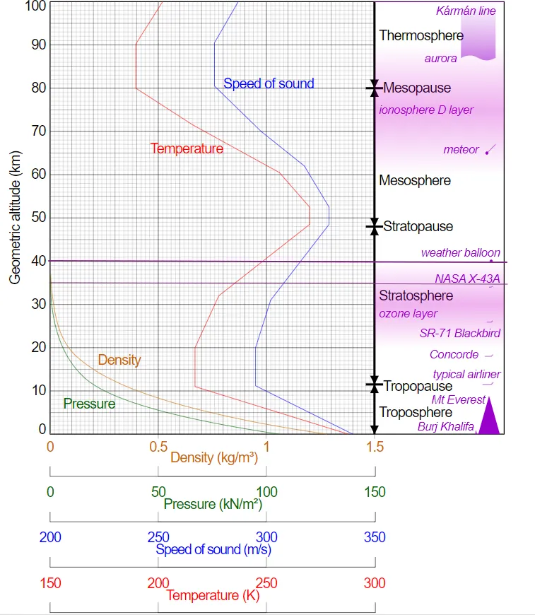
Pic. 16 The standard cross-section of Earth’s atmosphere with 2 purple lines marked at altitudes of 35 and 40km, which correspond to the position of the Belt of Venus and appear to mark the border between the observed atmosphere density. Upper – thicker line marks altitude with a dip of the horizon equal to 6 degrees when we include the standard refraction coefficient. A lower, thinner line marks the same value of dip of the horizon when refraction is completely neglected (Wikimedia.org).
This particular altitude marks the distance from Earth’s surface at which the daylight zenith sky appears to be completely black. You won’t agree with me by browsing some records from the level of the meteorological balloon, where the sky looks completely black even at an altitude of 30km or smaller. The problem, which should be taken into account is the dynamic range of the mounted cameras, which often the Earth’s surface quite clearly on account of the sky. It will be for sure another topic for this website in the future. For the time being the described altitude shall be treated as the final upper boundary for the aerial long-distance observations within Earth’s environment.
E. Extraterrestrial long-distance observations – the example considered earlier is the easiest, as we stick to the Earth’s analogy. I mean, the topic revolves around the planet which has its own atmosphere, therefore the upper boundary can be defined on the same basis as described above. The following rule won’t work either for gaseous types of planes or for celestial bodies deprived of their own atmosphere.
What criteria shall we construe for these cases?
For Earth-like planets, dwarf planets, and moons, without a gaseous envelope, the most reasonable boundary seems to be marked by the highest peak/mountain/protrusion observed at its surface. Any type of sight captured from a higher elevation will fall under the astrophotography matter.
Conversely, for gaseous planets like Jupiter, there is no possibility for ground-to-ground long-distance observations, because the ground in a practical sense doesn’t exist.
F. The shortest distance for any type of long-distance observation – despite wide discussions about what closest sight should be classified for long-distance observation, there is still no proper definition determining the lower limit for various types of objects. In the case of high mountain ranges, the distance must be “at least 90-100km”, for other mountain ranges – 60km, and for industrial objects between 40-50km.
Because these limits seem to be too ambiguous I am going to propose another approach in the future.
6. POTENTIAL SCIENTIFIC APPLICATION
There are a few ways in which observations such as these could be utilized from the scientific point of view. The studies could cover:
– the behavior of anomalous refraction in the atmosphere and the meteorological reason for it,
– the frequency of low atmosphere air turbulence and its impact on climate changes,
– periodical changes in the atmosphere transparency as a measurement of haze pollution and monitoring the changes in local air dynamics
– psychology and perception of the psychology in various societies.
– impact on tourist value of the given place in the situation, when some distant view becomes commonly known
7. SUMMARY
The following article undertakes the pioneering approach of identifying the basic types of long-distance observations. This kind of observation, although commonly known for ages hasn’t lived to see the appropriate division and description. Therefore this writing comes out with a reasonable proposal, which is based on the scant literature treating both aerial, ground-to-air, and ground-to-ground long-distance observations as just one kind of topic. Moreover, the lack of an upper limit for this kind of sight leads to the mistaken conclusion, that long-distance observation might cover even celestial objects located far away from Earth. On the other hand, the minimum length of the line of sight marking the given observation as distant still doesn’t exist, which can be translated problematically by some groups of people. Despite not having big resources in science this realm has a chance to be a decent outreach for scientific research of the Earth’s atmosphere and meteorological sciences.
Mariusz Krukar
References:
- Bohren C., Fraser B., 1986, At what altitude does the horizon cease to be visible? (in:) American Journal of Physics vol. 54, p.222
- Dietze G., 1957, Einführung in die Optik der Atmosphäre, Akad. Verl.-Ges. Geest & Portig, Leipzig
- Gupta S., Mangold N, et al., 2022, A delta-lake system at Jezero crater (Mars) from Long distance observations, (in:) 53rd Lunar and Planetary Science Conference, The Woodlands, USA
- Krukar M., 2020, Oszukać atmosferę – najodleglejsze obiekty, jakie jesteśmy w stanie zobaczyć (in:) Geografia w Szkole nr2/2020.
- Lynch D.K., 2008, Visually discerning the curvature of Earth, Thule Scientific, Topanga, California
- Mietelski J., 2009, Astronomia w geografii, PWN, Warszawa
- Pong Lau C., Hin Lai Y, Ming Lui L, 2019, Restoration of Atmospheric Turbulence-distorted Images via RPCA and Quasiconformal Maps, (in:) Inverse Problems, vol.35, no.7
- Vollmer M., 2020, Below the horizon – the physics of extreme visual ranges, (in:) Applied Optics, vol. 59, no. 21
Links:
- https://dalekiewidoki.pl/obserwacje-dlugodystansowe (Polish)
- The longest sightline on Earth
- 500-mm.blogspot.com: Dalekie-obserwacje-cz-1.html (Polish)
- https://zdlugiejrury.pl/vademecum/ (Polish)
- https://beyondrange.wordpress.com/2014/09/03/the-longest-pictures-ever-taken/
- https://500-mm.blogspot.com/2020/04/puy-de-dome.html (Polish)
- http://wwwobs.univ-bpclermont.fr/opgc/webcam.php
- https://slate.com/technology/2009/01/how-far-away-is-the-horizon.html
- https://www.irishtimes.com/news/science/seeing-beyond-the-horizon-1.4587533
- Aty.sdsu.edu: Distance to the horizon
- https://www.davidsenesac.com/Information/line_of_sight.html
- Earth’s Curve Horizon, Bulge, Drop, and Hidden Calculator
- Livescience.com/7-ways-to-prove-earth-is-round.html
- https://www.wonders-of-the-world.net/Eiffel-Tower/Visibility-from-the-top.php
- Aty.sdsu.edu: Calculation altitudes of distant features
- https://www.spektrum.de/lexikon/physik/optische-erscheinungen-der-atmosphaere (German)
- Aty.sdsu.edu: Dip of the horizon
- Distance to the horizon calculator
- Advanced Earth curvature calculator
- Travelandleisure.com: Why do planes fly at 36000 feet cruising altitude
- Walter.bislins.ch: Deriving Equations for Atmospheric Refraction
- https://dalekiehoryzonty.pl/refrakcja-atmosferyczna/ (Polish)
- Phy6.org: The round Earth and Christopher Columbus
- https://www.google.com/mars/
- https://www.wykop.pl/artykul/3992157/dalekie-obserwacje-na-marsie/ (Polish)
- https://www.foto-webcam.eu/
- Notes on the Dip of the Horizon
- https://beyondrange.wordpress.com/2018/07/11/in-flight-pictures-mont-blanc/
Forums:
- Forum.flightradar24.com: Planespotting Meeting Astrophotography
- https://earthscience.stackexchange.com/questions/7283/how-high-must-one-be-for-the-curvature-of-the-earth-to-be-visible-to-the-eye
- https://www.quora.com/At-what-altitude-does-the-curvature-of-Earth-become-visible-to-the-naked-eye-without-requiring-a-60-degree-FOV
- https://www.reddit.com/r/askscience/comments/b2kbz8/if_you_were_standing_on_the_moons_surface_would/
- https://gis.stackexchange.com/questions/4690/determine-angle-down-to-horizon-from-different-flight-altitudes
- Unmannedspaceflight.com: Mars & Missions
- https://astropolis.pl/topic/59958-dalekie-obserwacje-na-wikipedii/page/2/ (Polish)
Wiki:
- Aerial_photography
- Aircraft_spotting
- Arm_span
- Belt_of_Venus
- Condensation_cloud
- Contrail
- Flue-gas_condensation
- Horizon
- Karman Line
- Line_of_sight
- Satellite Watching
- Skyline
- Stratosphere
- Weather_balloon
Youtube: