
This article is sort of a continuation of issues related to light scattering in the Earth’s atmosphere as well as haze presence. These subjects are closely associated with each other, so some stuff presented here can be pretty much similar and it will be developed on the grounds of my previous articles. This 2-partial article leads to explain when is the best time to attend to long-distance observations and what elements contribute to this kind of tourism and photography.
- WHAT IS THE VISIBILITY?
At the beginning let’s say what is the visibility. Visibility has varied and diverse meanings. I will consider visibility in the meteorological aspect. In meteorology, visibility determines the degree of atmosphere clarity and is usually referred to as the maximum horizontal distance through the atmosphere, that an object can be seen by the unaided eye (Bennett, 2016). There are 2 kinds of visibility:
– Vertical visibility, which determines how far can we see up or down. In practice, this feature is varied due to meteorological conditions (like the planetary boundary layer) described in the previous article. Vertical visibility is also a distance, that an observer can see vertically into a surface-based obscuring phenomenon, such as fog, rain, and snow (McGraw-Hill Dictionary, 2003). In aviation, vertical visibility is the maximum height from which a pilot can recognize ground features when the surface is obscured because of a meteorological phenomenon.
– Horizontal visibility, which is usually more important, because it affects our ability to view distant landscape features. Those distant landscape features are prominent objects, that can be identified with the naked eye, typically referred to as the atmospheric or meteorological visual range (Malm, 2016).
Visibility can be treated as an environmental quality that is valued for aesthetic reasons that are difficult to express or quantify (Hyslop, 2009). Everywhere we have locations, that can boast a scenic landscape closer or further. Unfortunately, air pollution and another big haze concentration can degrade closer scenic vistas and obscure those, located further from the observer. The particular matter affects visibility in multiple ways: obscure distant objects drain the contrast from a scene and discolors the sky (Hyslop, 2009).
In previous decades visibility was almost exclusively used to denote the human capability to detect, recognize and identify objects. Since the industrial revolution, when many pollutants have been emitted into the atmosphere visibility emerged as an aesthetic concern, especially within protected areas. In this article, I would like to enclose the factors, which influence the horizontal visibility range, highly important for long-distance observation purposes.
2. INFLUENCE OF THE DIFFERENT FACTORS ON THE HORIZONTAL VISIBILITY RANGE
2.1. ASTRONOMICAL FACTORS
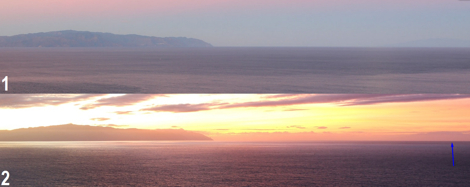
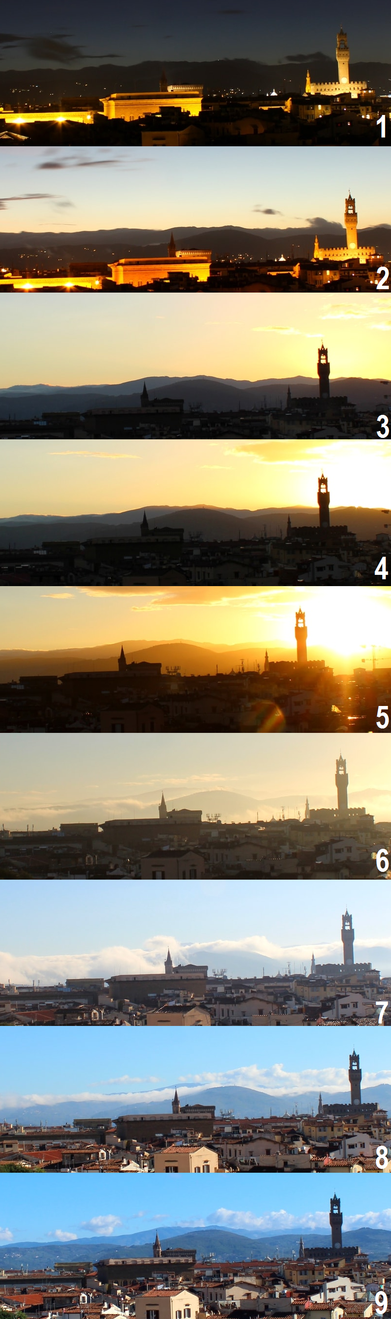
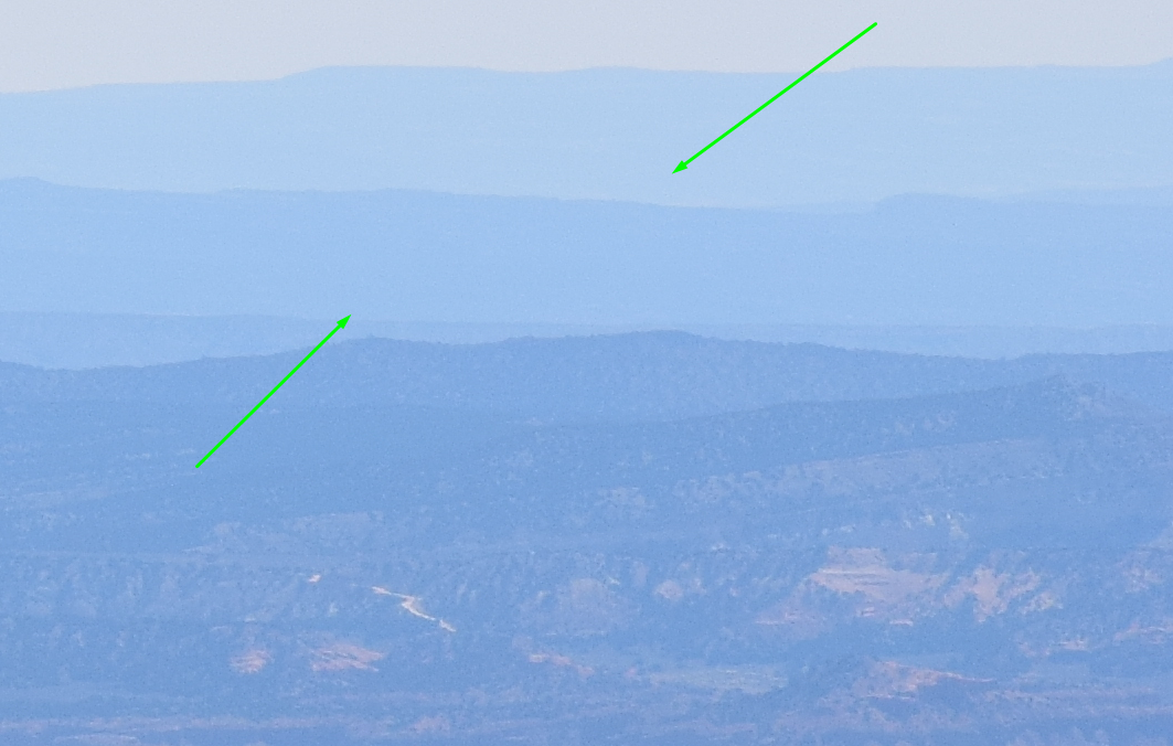
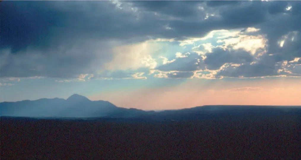
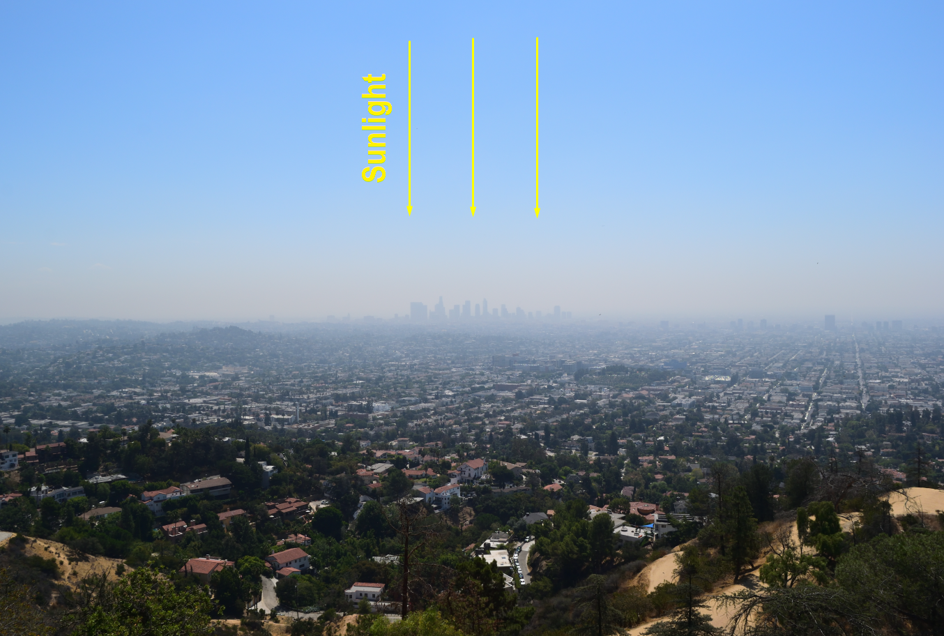
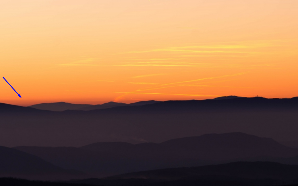
The most obvious astronomical factor is the diurnal position of the Sun, our other main source of illumination at night. The position of the Sun will determine the angle between the source of illumination and the object observed. In my previous article about haze, I developed this topic. When our object is to be found in more or less the same direction as Sun, then it can be hardly recognized due to the whitish haze appearance caused by forward scattering. Furthermore, the angle at which the Sun illuminates a vista or landscape feature (Sun angle) plays another important role. First, at higher Sun angles there is less scattering of light by the intervening atmosphere in the direction of the observer. Second, the vista reflects more light; consequently, more image-forming information (reflected photons from the vista) reaches the eye. The contrast detail and scene are enhanced (Malm, 2016). The distant objects watched on the same part of the sky where the Sun is located are more or less shaded by themselves, hence providing fewer details. It is far better to see the objects on the opposite side of the Sun, which is much better illuminated. Conversely in the case of twilight, when objects on a similar azimuth to Sun plunged into the horizon are better visible due to light scattering properties (see below) (Pic. 1).
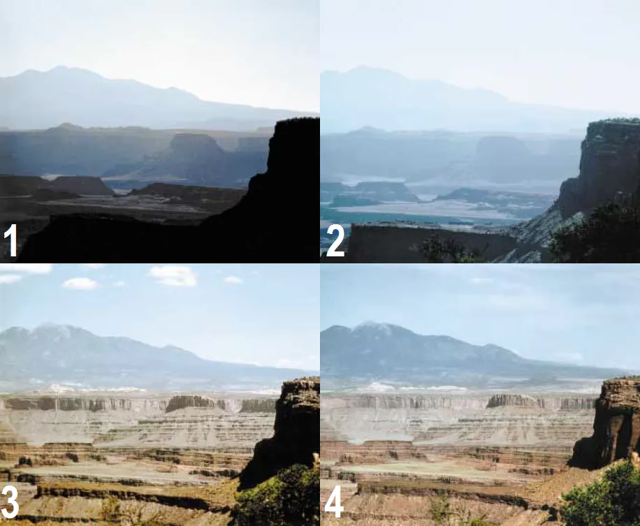
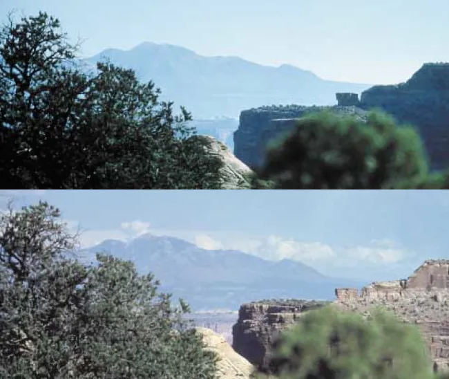
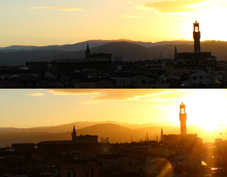
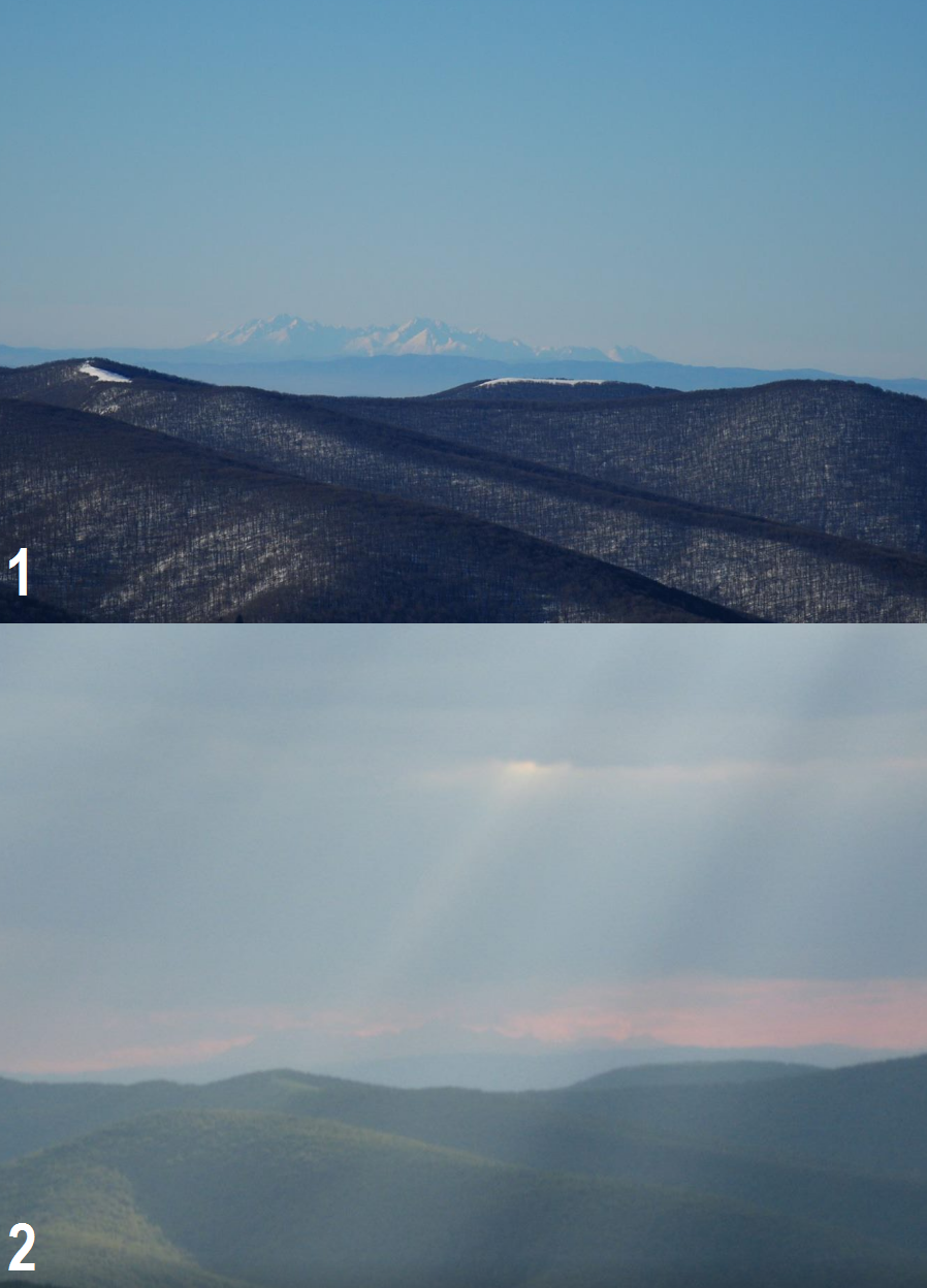
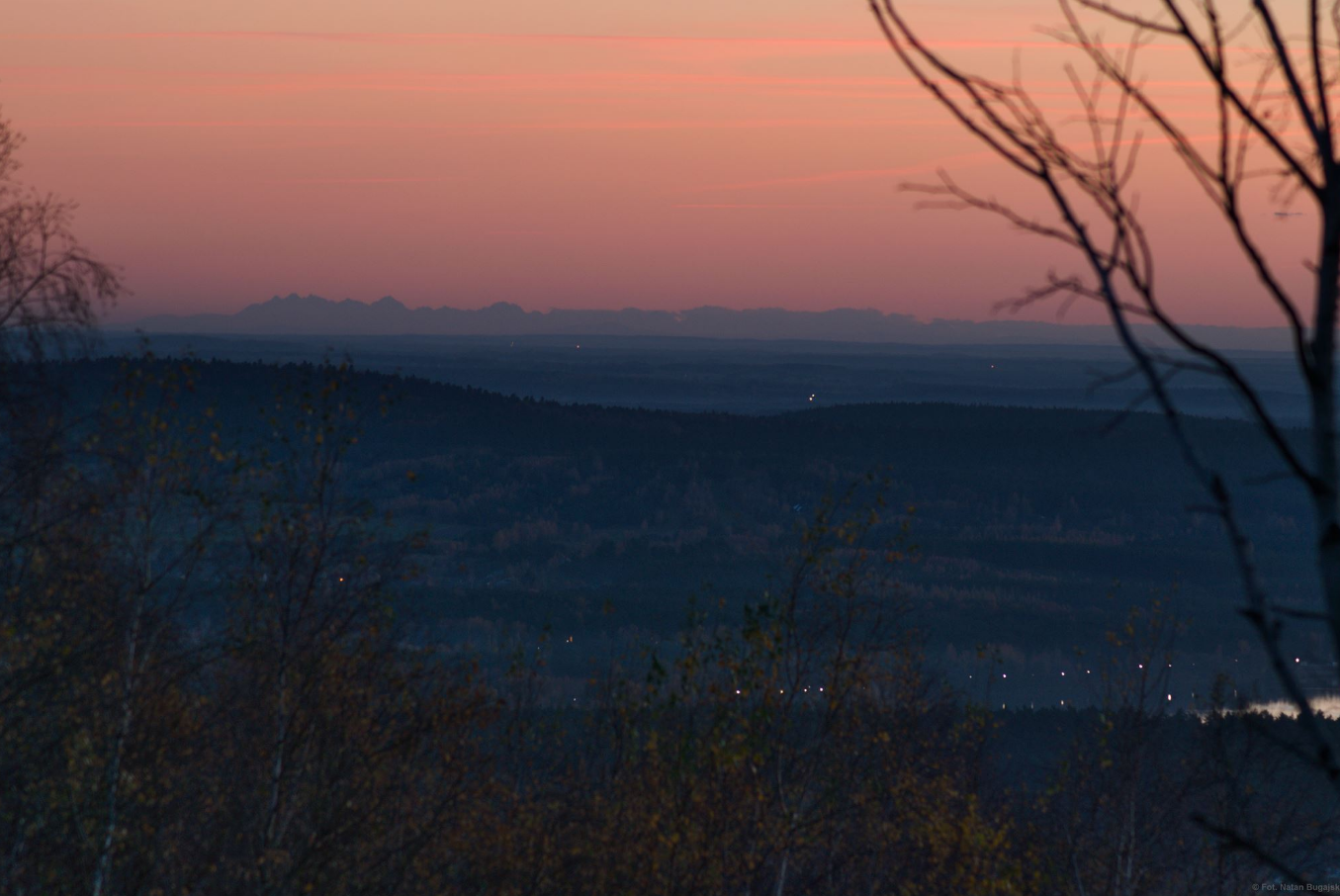
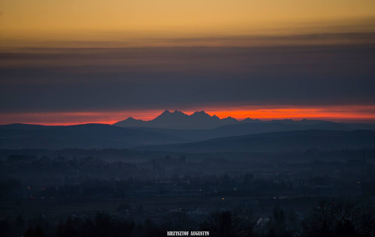
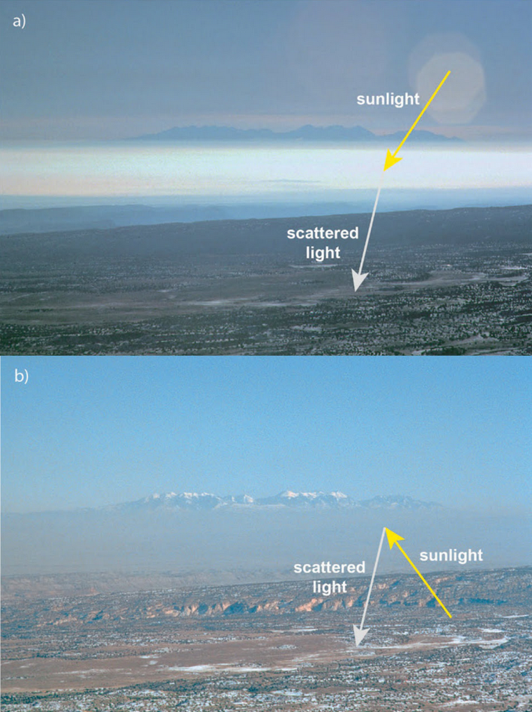
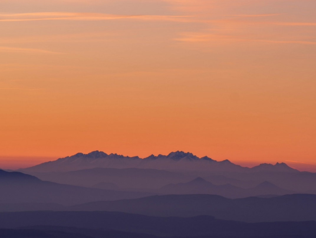
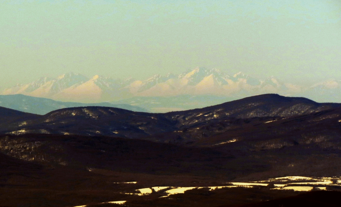
The situation changes rapidly when looking at distant objects around sunrise or sunset. To be more precise, a very important moment of the day is the golden hour with Sun above the horizon. This is the time when the surrounding view changes in general. The Sun angle-vista-observer geometry is very unfavorable due to forward scattering, which increases at the solar azimuth, as Sun goes down. Conversely to solar azimuth, the Sun altitude is low enough to give a decent view towards the antisolar direction. The view towards the opposite side of the solar position is good during the whole period between noon and the golden hour, however, when Sun is located lower in the sky, the view appears to be the best. This is driven by extinction, which starts to play a big role, hindering some parts of direct sunlight on a long way throughout Earth’s atmosphere. It results from a bit less amount of light scattered on haze particles and molecules, giving a view more discernable. Remote mountains have a bigger contrast against the yellowish sky beyond them (Pic. 3).
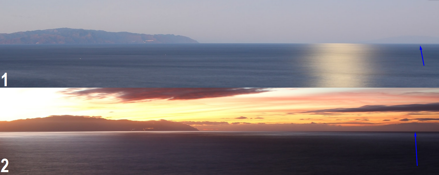
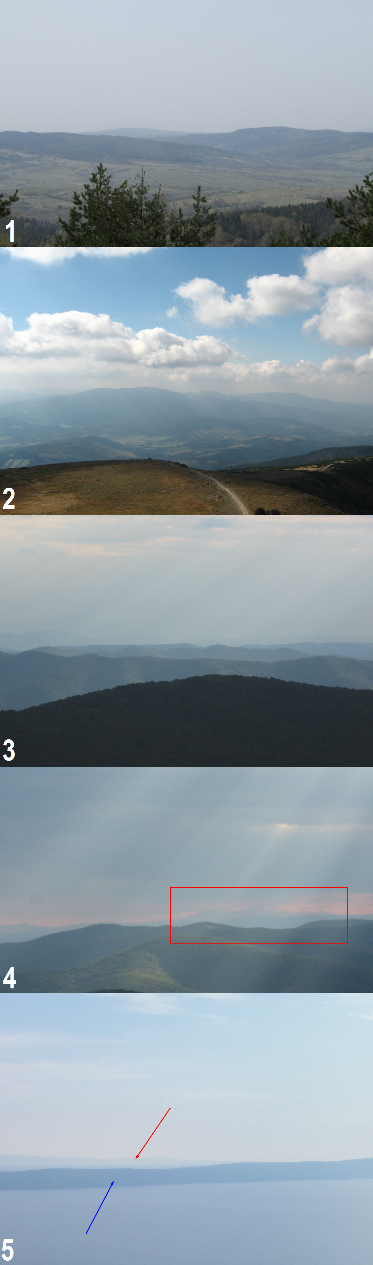
When sunlight diminishes around sunrise or sunset then remote objects seem to be visible better in all directions, except an exact solar azimuth. This is the time when direct sunlight scattering on aerosols vanishes (Pic. 4, 5). Indirect sunlight conditions the haze particles or air molecules to eliminate the visual contrast that would have made the most distant horizon visible. The contrast changes depending on the illumination and extinction coefficient.

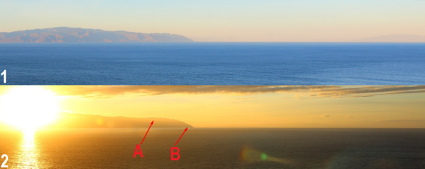
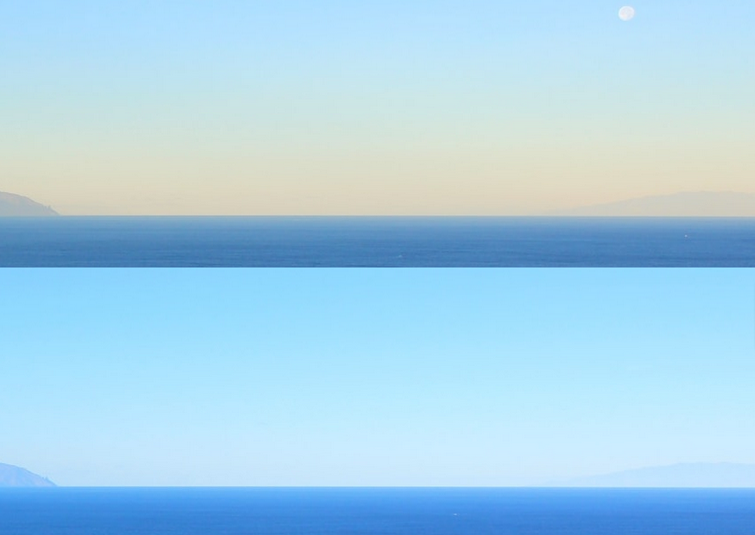
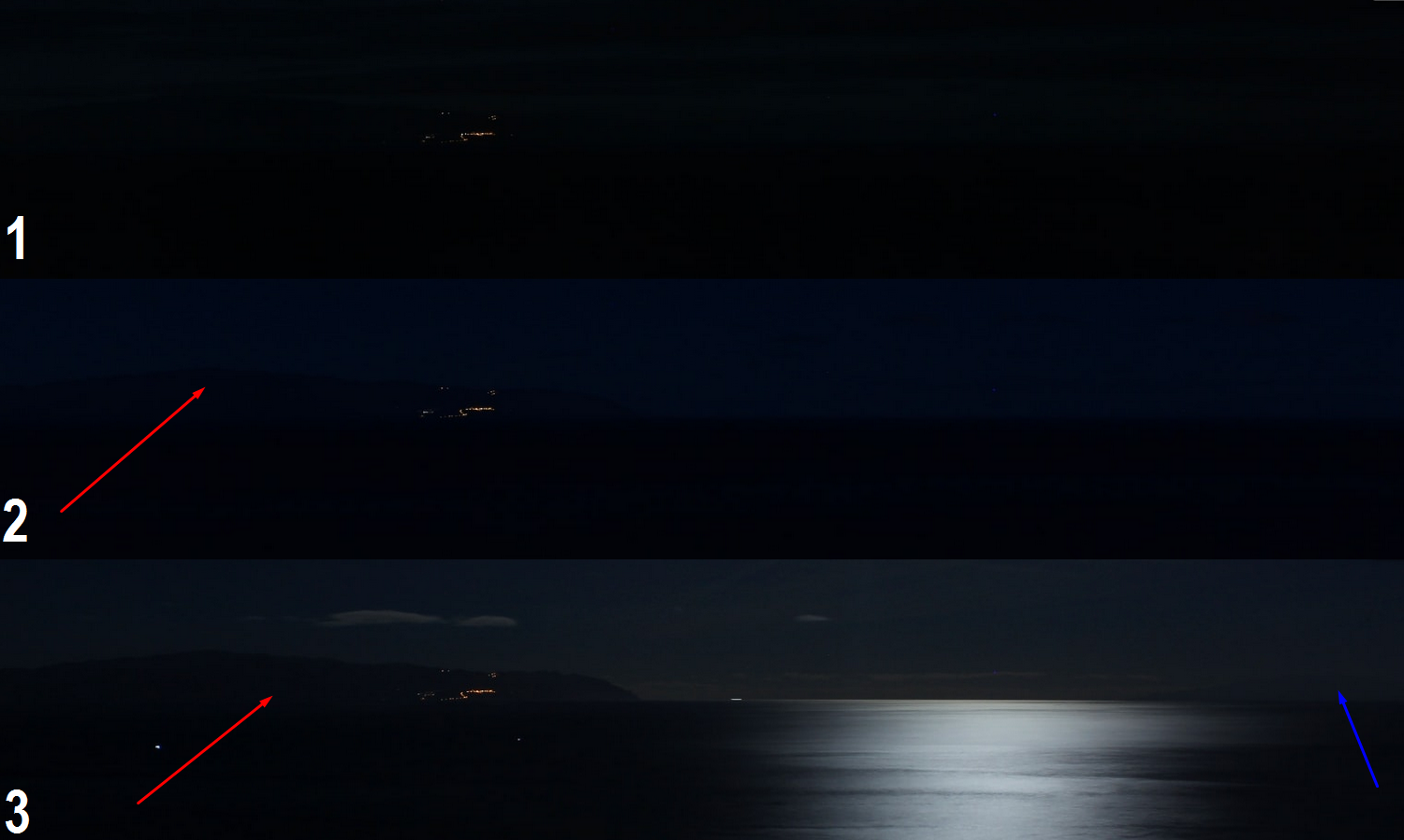
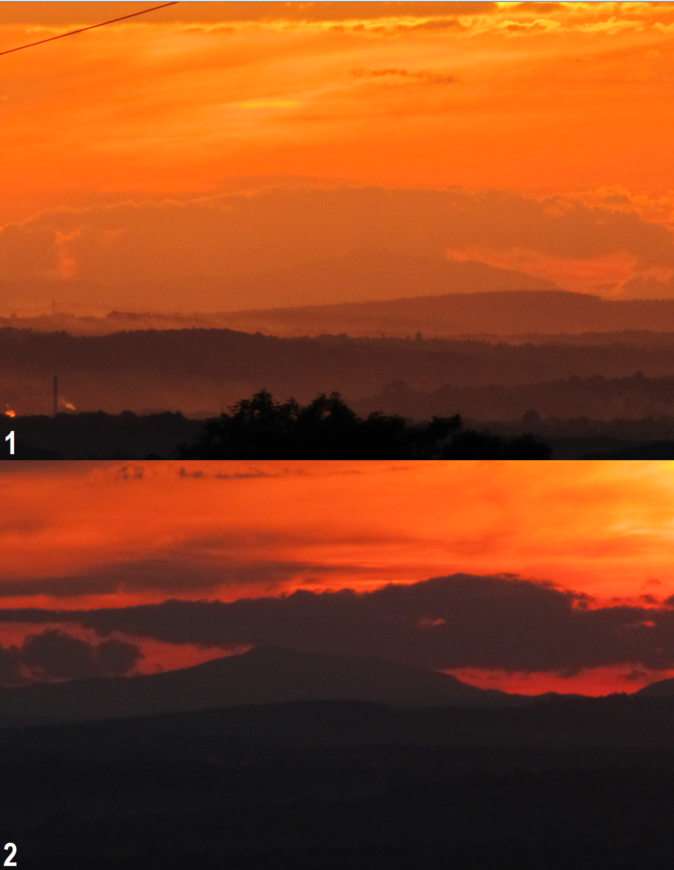
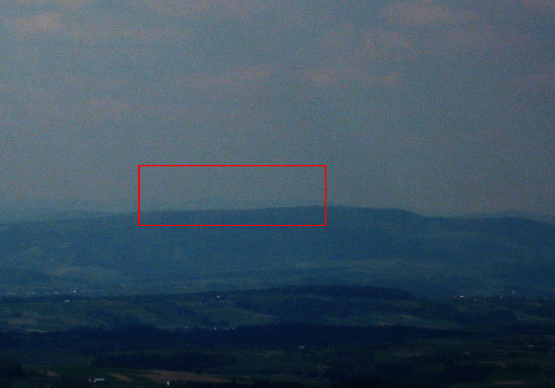
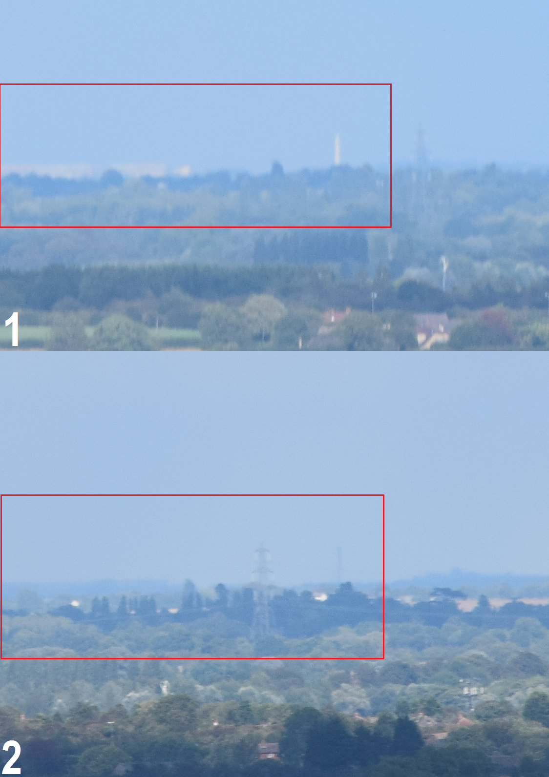
The extinction coefficient means how quickly the beam is attenuated as it passes through the medium. The small extinction coefficient means, that the medium is relatively transparent to the beam. For example, our beam is a remote object and the medium is the air. Diminishing and disappearing sunlight when the sky remains bright pushes the contrast threshold of the human eye making the distant target visible (more details in the next part of this article). The air molecules and haze particles don’t scatter the sunlight anymore. Sunset marks the moment when forward scattering disappears. The opposite situation occurs daily at sunrise, where forward scattering appears again. This moment is called a sunrise or sunset transition, which has been described more in my previous article. A practical explanation of this phenomenon can be found in Pic. 6 when looking at points A and B marked by the red arrow. They show a rough sunset transition moment, which changes the visual range abruptly. In Pic. 6, image 2 point A is an example, where forward scattering still occurs due to direct sunlight presence. Point B is already shaded with a lack of direct sunlight scattering, which makes far better contrast against illuminated the lower part of the atmosphere. It makes, that our object perfectly visible.
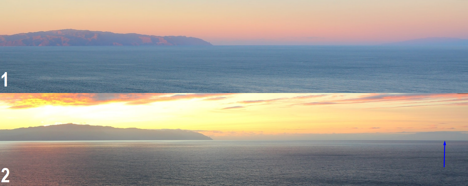
Forward scattering usually makes an object less visible than backward scattering. When forward scattering disappears it gives way to see the remote objects, that we were not able to see during the sunlight conditions (Pic. 7).
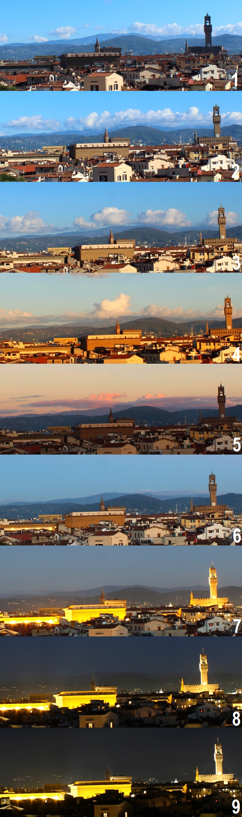
After sunset, the light scattering takes place in the atmosphere. For our line of sight, we face a secondary scattered light, present in the lower, shaded part of the atmosphere. Moreover, most atmospheric aerosols have an extinction coefficient decreasing in magnitude with increasing wavelength (Horvath, 1967).
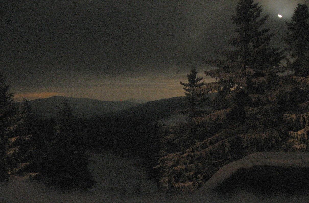
We have to bear in mind that a favorable visibility condition after sunset will last as long as the stratosphere (ozonosphere) is illuminated (Pic. 10, 11). After this, the light scattered in the upper part of the atmosphere is too weak to make a good contrast with the distant object observed.
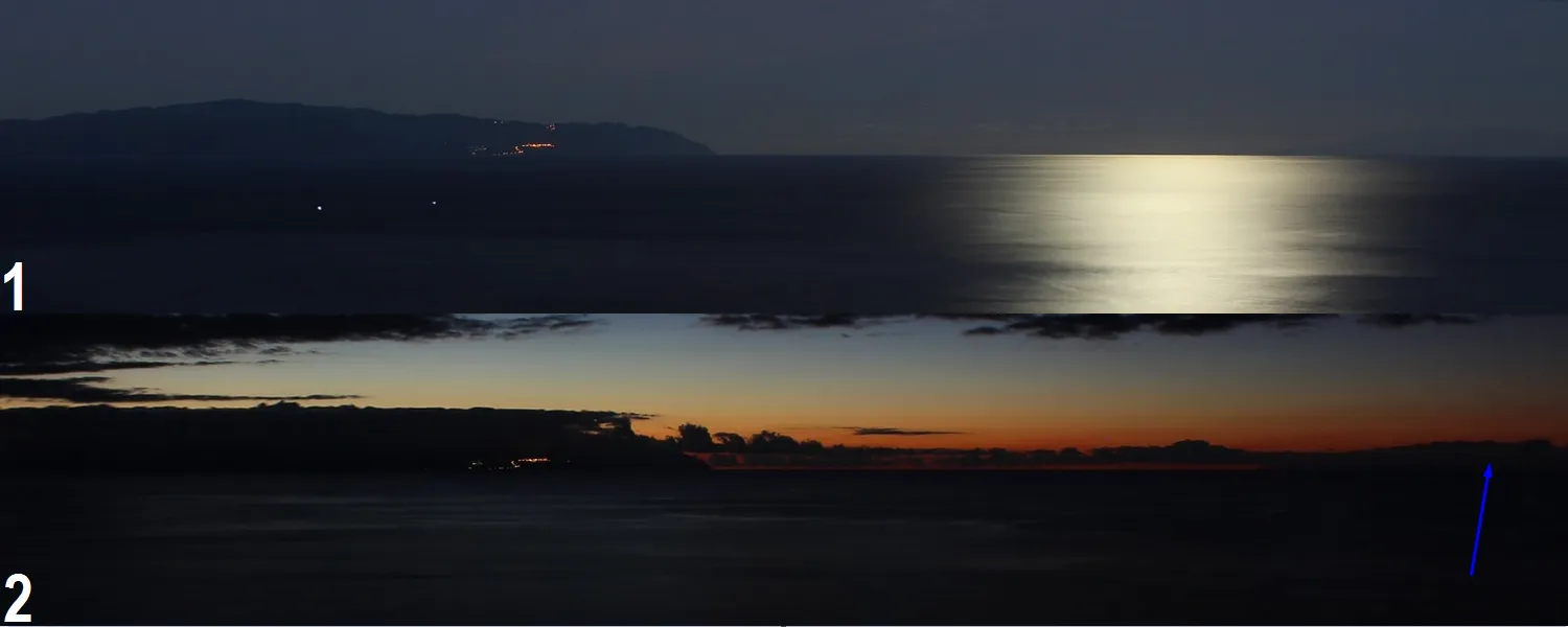
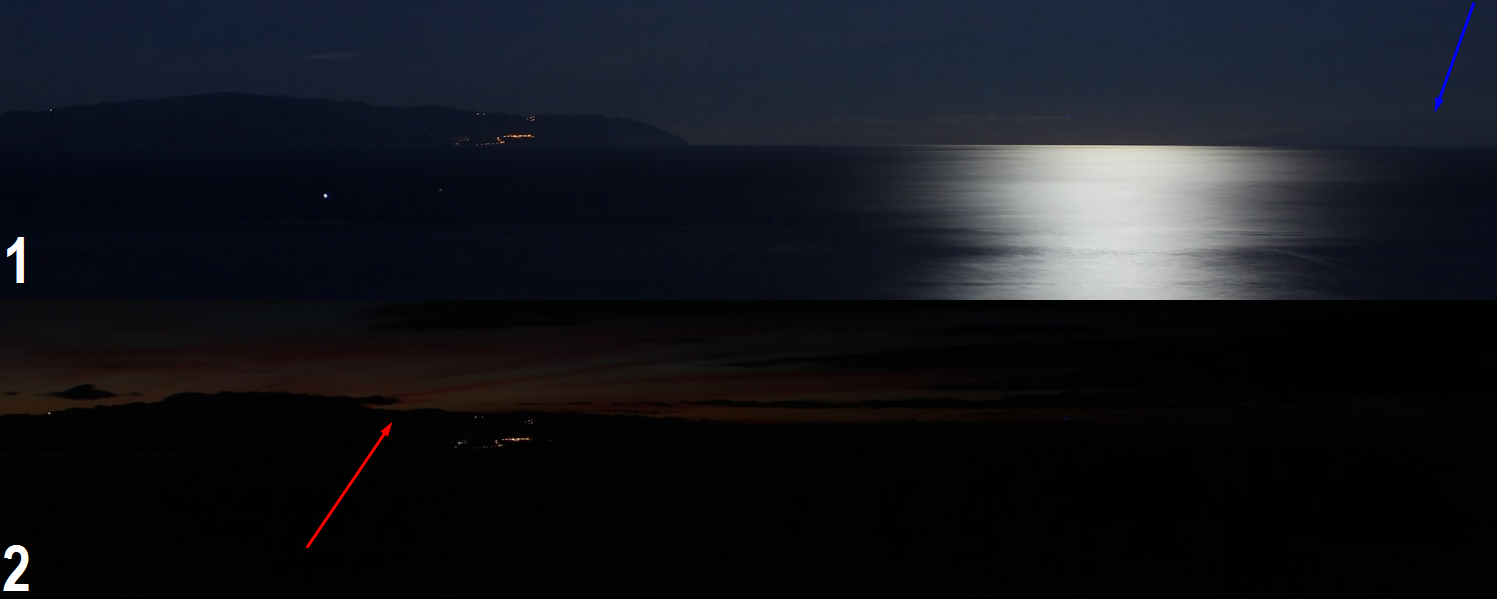
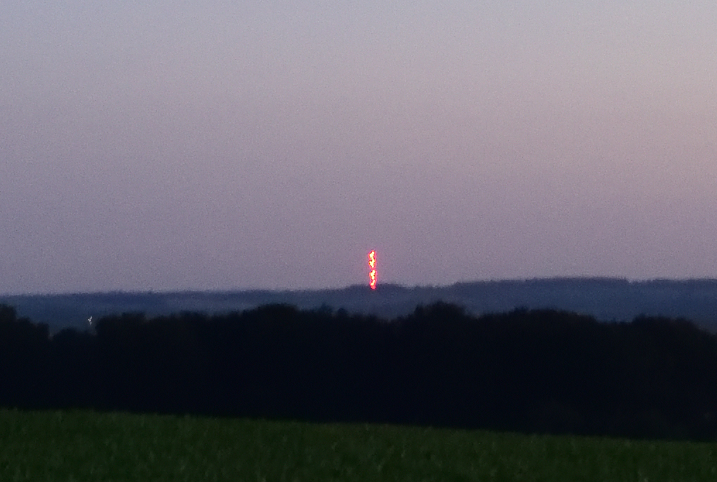
In the nighttime hours is really hard to distinguish some distant objects, unless they are illuminated by local light pollution or moonlight. In the second case everything is going to be analogous to daylight conditions, however capturing proper pictures will require a long time of exposure, unlike the webcam example provided. (Pic. 13).
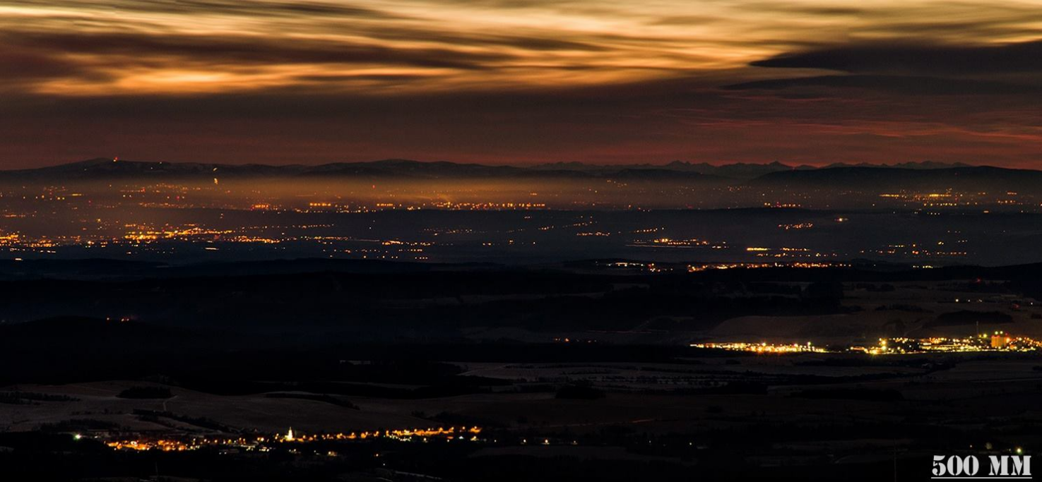
Now let’s see an example of perfect quality of distant view in night conditions, as we can gain with long exposure and light pollution assistance (Pic. 15).
To summarize this section I would like to show the visibility conditions under a different Sun position against the horizon at the antisolar direction, unaffected by forward scattering.
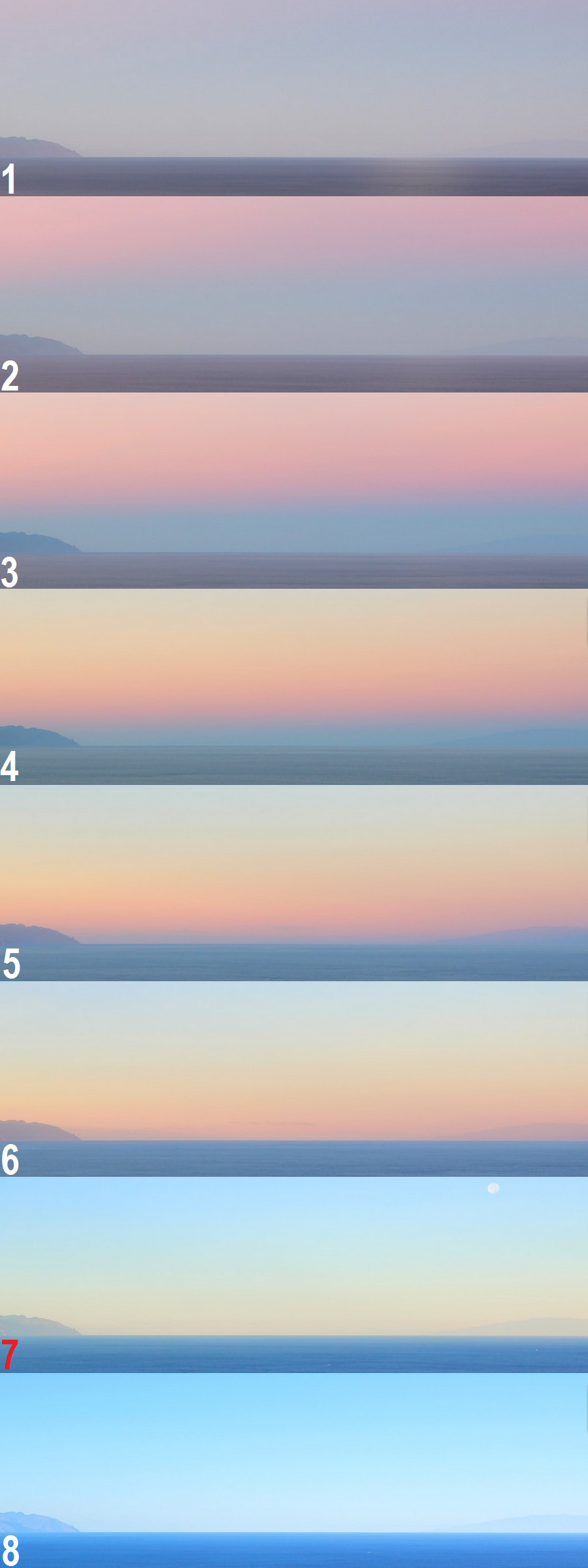
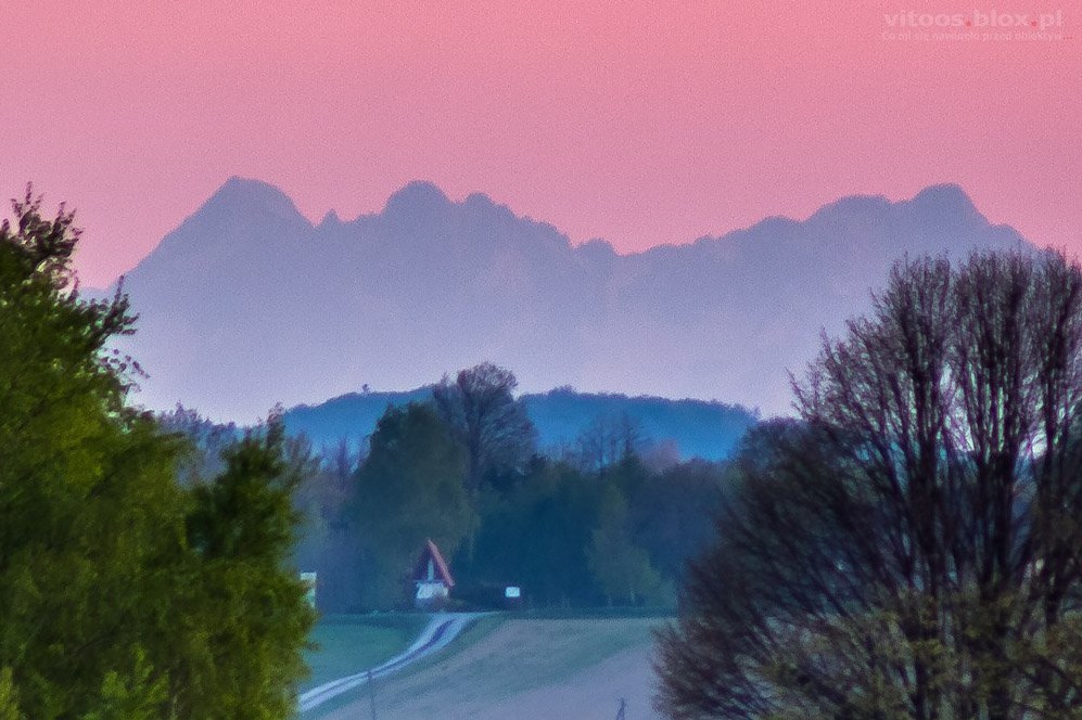
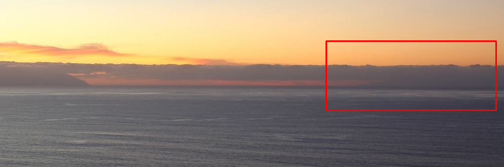
Looking on pic. 16 we can say straight, that the best visibility conditions at the Sun – observer – vista geometry occur about 15-20 min after sunrise or before sunset, which has been marked in image 7. Some of you will ask, why particularly at that moment, whereas image 5 shows even better conditions for La Palma island. The point is, that the sunrise or sunset transition in an antisolar direction is to be seen in the sky too. As a consequence, these objects, which lie very far from the observer can be merged with the receding twilight wedge, which makes the horizon still not bright enough. Only the prominent mountains, which are high enough, can rise above this line, making a decent contrast between themselves and the bright sky beyond, as the La Palma island does in the example provided.
Below I have gathered all major moments when visibility towards a particular direction changes throughout the day (Pic. 17, 18).
It’s good to mention also a seasonal variation of the sunrise and sunset azimuth, also in understanding civil and nautical twilight azimuth, which can improve or deteriorate the visual range in a particular direction.
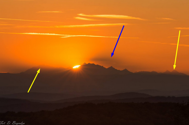
An important astronomical factor, which can decide about seeing distant objects, even when they are totally hidden behind a thick haze is solar ephemera. Knowing roughly an azimuth of sunrise or sunset we can try to capture a distant mountain on its disk (Pic. 19). It also works in the case of the Moon, however, when the haze is too thick Moon tends to disappear before the set.
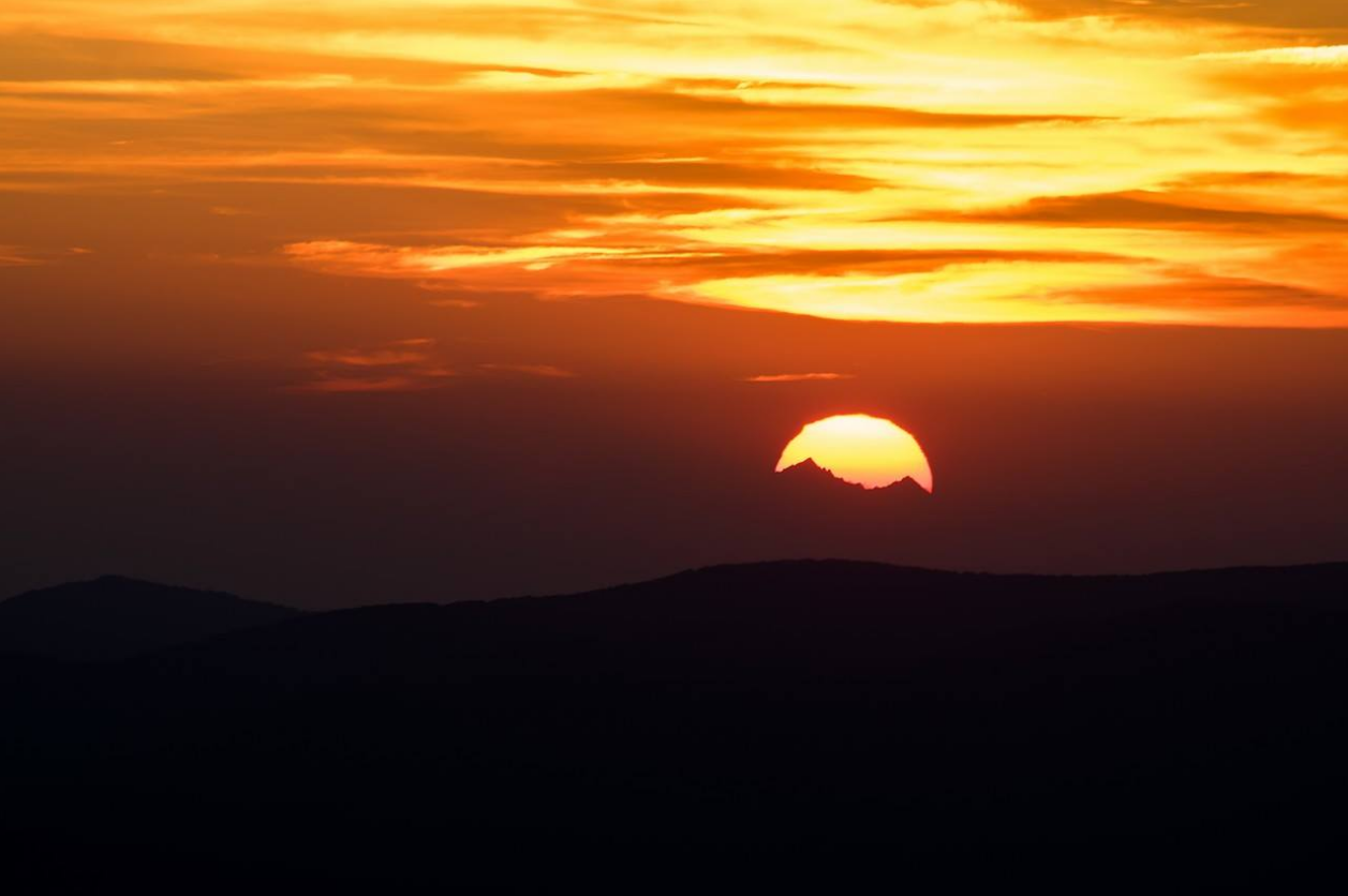
A lunar ephemera may help to capture a distant object only when haze concentration is low. Then a moonrise or moonset above some remote and not illuminated enough object will be beneficial (Pic. 20).
The details of checking the solar and lunar ephemera have been described in this article.
2.2. WEATHER FACTORS
A. AIR MASSES
Every air mass provides different conditions of horizontal visibility. I am going to remind you a bit of some stuff from my previous article, where I briefly explained the air mass influence on the visual range. Basically, the map below shows the types of air masses, as an influence on the weather throughout the year (Pic. 21).
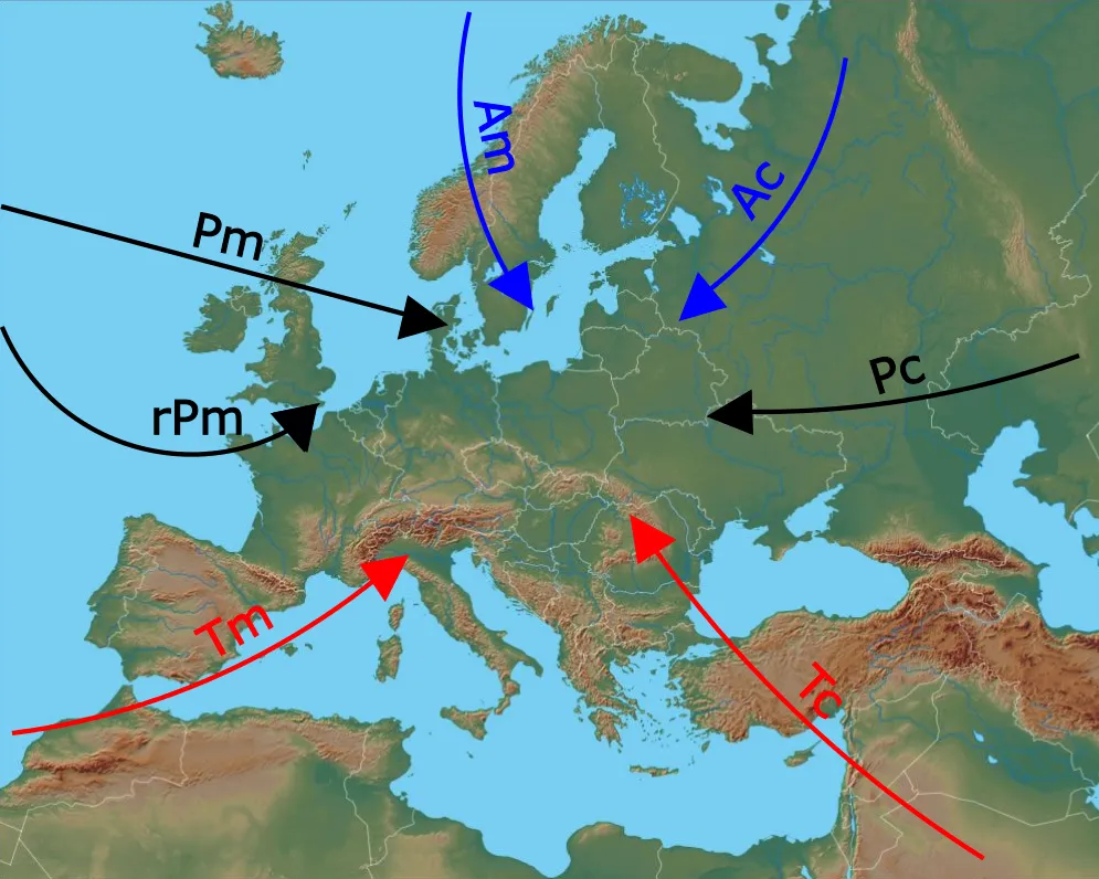
The Arctic air mass, which we can divide into continental and maritime is the clearest, which comes to Europe. The reason for its transparency lies in the lowest amount of particles coming from the local basement. The polar regions are (at least now) mostly covered by ice and snow, hence all particles, which could potentially be blown by wind are trapped underneath. It makes the Arctic mass the clearest air mass, as we can see. However, it’s good to point out, that the clearest is the Arctic continental air mass, which comes to Europe from the Barents Sea direction. The Arctic maritime air mass may contain some marine aerosols, which will impair visibility a bit. Moreover, this kind of air mass always features a bigger humidity level (showers in places), which is unfavorable for visibility too.
Because of increasing pollution around the Globe, we must be aware, that arctic air mass contains some arctic haze, which enters from lower altitudes and urban areas through the long-range pollution pathways.
An Arctic air mass comes to northern and central parts of Europe. Usually, this air mass is transformed, when entering the southern part of the continent.
The polar maritime air mass is another common air mass, which influences the weather in Europe. Within this air mass, we can make a division between Polar maritime air mass and returning Polar maritime air mass. The second one arises out of a long journey above the sea surface, which takes the air first southwards the North Atlantic and next north-eastwards towards western Europe. In general, Polar maritime air mass brings good, or even excellent visibility depending on the period of the year, when hits the ground (is the ground warmer or colder), and local weather patterns (some showers in places may strongly interrupt a visual range). We can expect this air mass when the wind blows from the west and northwest towards Europe. A returning polar maritime air mass features only moderate visibility due to high humidity and marine aerosol concentration. It comes usually from WSW and SW directions to continental Europe.
Polar continental air mass influences a bit less into the weather in Europe because the western winds take hold for most of the year on the continent. However, during the winter period, the frequency of this air mass is bigger, than during the summer. Next to more extreme temperatures, as we can observe under this air mass condition, the visual range is rather moderate or good, but not perfect. Despite a low level of humidity, this kind of air mass may contain a lot of continental haze (rural continental aerosols) or some pollutants, especially during the summer. In winter, when eastern Europe is covered by snow, this air mass features better visibility conditions.
Tropical maritime air mass usually come to Europe from the southwest. In all periods of the year, this air mass brings higher temperatures and high humidity, which results in really poor visibility. Because this air mass originated at tropical latitudes, it features very often higher temperatures, than the ground underneath, which leads to additional humidity increment.
The tropical continental air mass is the last type of air mass, that enters Europe from time to time. Likewise a maritime one, the tropical continental maritime usually plays a big role in the Mediterranean region, unlike central Europe, where it comes occasionally. Usually, this type of air mass brings much higher temperatures and dry air, often abundant with dust from the desert. In this configuration, combined with a usually colder surface, the visibility conditions are also quite poor, or at most moderate.
Because this article can read people from another part of the world I would like to mention another two major air masses, which are equatorial and antarctic.
Equatorial air mass has only maritime features. It usually brings frequent thunderstorms and high temperatures. In this case, the visibility conditions are usually restricted and depend on local weather pattern only. However, even in these climes, some days with decent visibility can be recorded (Pic. 26). Higher air mass temperature has the ability to store a bigger amount of water, decreasing a humidity level at once.
Antarctic air mass has only continental features due to massive land surrounding a south pole. This air mass appears to be the clearest air mass observed on the Earth, especially now, that the ice sheet in the Arctic area has been melting down. This most transparent air mass can be polluted only by arctic haze, whose origin is the same as in the Arctic.
B. VISUAL RANGE CHANGES INSIDE A PARTICULAR AIR MASS
Previously I have considered the usual characteristics of the visibility conditions in the main type of air masses, however, there are many variations in individual air masses (Ackerman, Knox, 2007).
These changes are:
– Day-night-day humidity variations – the humidity is getting lower as the day warms, hence visibility is believed to be better during the midday time hours and usually the best in the early afternoon, which is the warmest period of the day (Pic. 27, 28). A humidity level can be also modified by wind speed.
– Air turbulences – play also a huge role throughout the day and are strongly associated with humidity variations under convective weather conditions. When the temperature rises, the steaming from the ground rises too, and vertical turbulent updrafts become stronger. More intensive steaming from the ground leads to increased humidity, which next is transported up, resulting from a cumulus clouds development, just above the planetary boundary layer. This humid air is superseded by drier air, coming from a “free atmosphere”, that penetrates down. The result of this phenomenon is easy to spot between morning and early afternoon. In the morning our vista is misty, whereas the sky is free of clouds. After a few hours, when vertically developed clouds drift across the sky, our vista is a bit more clear. These situations can be observed usually during a warm period of the year.
– Atmospheric pressure – high atmospheric pressure leads to low wind speed, which causes increased pollutant concentration close to the pollutant sources and visibility deterioration (Majewski et al., 2015) unlike low pressure, which due to increasing wind speed provides effective ventilation, especially for urban areas. The low-pressure conditions are associated with convective weather, as described above. Convective weather produces low-pressure areas with convergence winds. A low-pressure area is produced at the boundary between warmer and colder air masses. More information about this will be provided in the next section. The opposite situation occurs under anticyclone weather conditions when atmospheric pressure is higher, then weather can be more stable for a longer time, resulting in a subsidence inversion development. This subsidence inversion can develop up to 2 km above ground depending on the pressure level. The subsidence inversion is a result of atmospheric pressure increases, which leads to air compression and heating. Warming of this air increases evaporation, causing usually clear skies within high-pressure systems. This inversion resists the convection of surface air since the surface air is stable and causes air pollution to be trapped at the surface. As a result, the visibility is really poor within this inversion layer, unlike the area above, which is unusually clear due to unusually dry air (Pic. 28) In the meantime underneath, where visibility is higher, some horizontal cloud development may occur. These clouds are difficult to disperse during the winter when the sun shines too low above the horizon and provides too weak radiation.
Subsidence inversion is different between winter and summer. In the warm period of the year, this inversion is less pronounced, at least during the day, when tails off due to much stronger solar radiation unlike in winter. Hence we won’t observe a vast visibility difference between the inversion layer and the layer above, as we can see in the colder part of the year.
– Temperature – is also an important weather element, which merges with pressure and humidity issues. Once the temperature is higher, then the water, being on the ground has a bigger ability to evaporation, however, a single air cube has a bigger volume at once. Then in wet areas, especially when water is colder than air the visibility conditions won’t be favorable. On the contrary, rising temperatures above dry (or frozen during the winter) landmass will decrease humidity, making a visual range more extended (like in the desert areas in the western USA). Inside the inversion layer, where the temperature is lower, the humidity level is higher, what we can see in a mist, fog, or partially developed cloud deck.
– Seasonal variations – can be significant, depending on where you live. In marine climes, there won’t be as considerable a difference as in continental climates. Considering Europe in general, the time with the best visibility occurs during the spring, when the temperature increases, but the air has only a little humidity after wintertime. The season with the worst visibility occurs usually in the late autumn when the air is reached with the humidity created by intensive summer rainfalls. It’s very important to say, that now we are considering only the conditions within the lowest part of the troposphere. As discussed above, the extended visual range during the winter comes from this layer of the air, which lies above the inversion, described below. Following the major seasonal trends of the visibility conditions, they can vary on the specified air mass moving across the area. In turn, the situation can turn rapidly and bring completely other visual range circumstances. For instance during the summer when much colder air mass approaches, what happens from time to time, usually after a heatwave. Then, if the surface over which an air mass is located is warmer than the air mass, the lower layers will be heated. It incurs a decrease in humidity and good visibility. This situation is observed when colder maritime air mass comes on the warmer continental surface (Pic. 30). The opposite situation can be observed during the spring or winter when much warmer air mass comes onto the surface, which is colder. Then the lower layers are gradually cooled. As a result water vapor and atmospheric impurities tend to be concentrated in low layers decreasing visibility effectively (Pic. 31).
Except for the tropic air mass advection, spring as a period features one of the best visibility conditions, because the temperature is still low and the ground is still cool, which prevents steaming. Polar continental air mass, which enters Europe doesn’t contain many aerosols, because this mass originates above still snow-covered (or if not, wet) areas of Eurasian inland. Arctic air masses can also occur during this time.
Autumn is a period with also good visibility when a Polar maritime or Arctic mass occurs. During this time poor visibility can be observed during Tropic and Polar continental air mass advection. Another favorable factor for good visibility during autumn is limited cloudiness in this period of the year.
The situation will be different i.e. in the USA, where excellent visibility is observed also during the summer. It arises out of a dry huge massive land and high temperatures. Moreover, the period of the worst visibility doesn’t indicate, that moments with good atmospheric clarity won’t occur. It depends on the local weather pattern, varying between years.
– Wind speed and direction – a good example here is the Foehn – a rain shadow wind (Pic. 31), which passes over the mountains and loses most of its moisture on windward slopes.
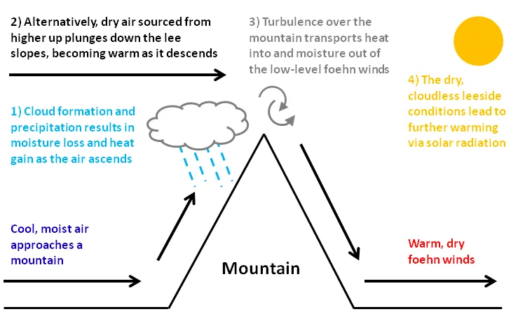
Being deprived of humidity at the leeward side this wind brings good or even perfect visibility conditions next to the pleasant warm (Pic. 32). Usually watching the main mountain range, above which a Foehn wind passes over an observer can spot a cloudy wall.
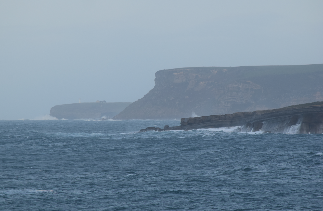
Wind plays a leading role in clearing the atmosphere of air pollutants. Usually, under windy conditions, the visibility appears to be better. On coastlines, when the wind is strong a lot of foam and seawater droplets rise from the seafloor reducing visibility considerably (Pic. 34).
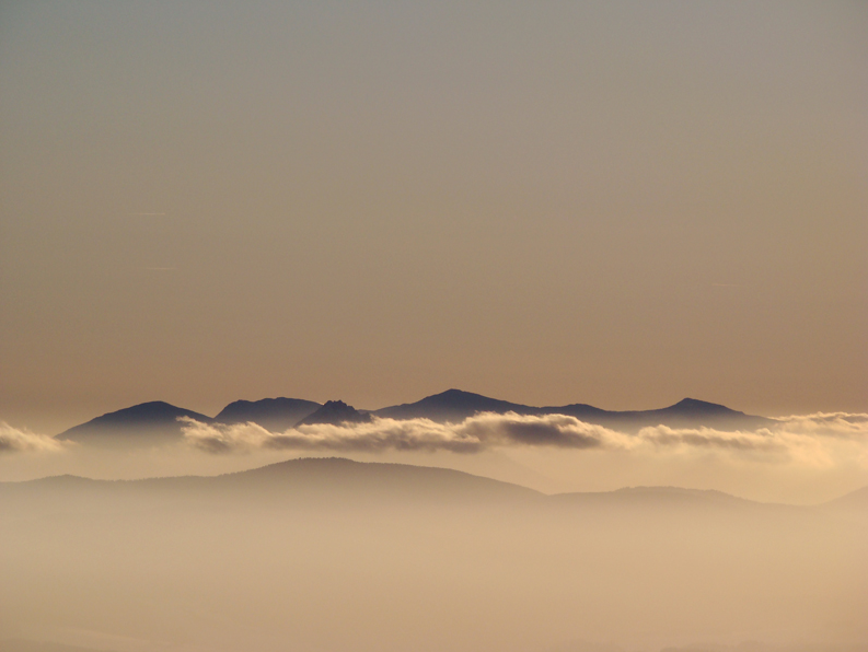
– The atmosphere density – varies in a vertical profile. As height increases the density of the atmosphere is lower. The densest atmosphere is in the lowest part of the planetary boundary layer, which is called the surface layer (Pic. 36). Usually, the visibility range is the worst there and improves as altitude increases (Pic. 35). We can often see it on the pictures with separated mountain ranges, which appear to look slightly more fuzzy at the bottom. However, in very transparent atmosphere conditions this phenomenon appears too and can be mistaken with the Mach Bands optical illusion, which has been described in my previous article (Pic. 37). A considerable improvement in visibility is noticeable when crossing the planetary boundary layer or at least the inversion layer.
– Cloud cover – this is ambiguous for visibility conditions. In general, the clouds shouldn’t affect air transparency, although their presence interrupts a visual range so much. First of all, the “safest” cloud decks for visibility conditions are the high-level or some mid-level clouds (i.e. cirrostratus, altostratus), which prevent a vista from solar beams and their scattering. On top of that these clouds often make a better contrast with distant objects, at least during the day (Pic. 38). More details about this I wrote in the next section below. Once lower levels of clouds or vertically developed ones are present in the sky, then our visual range can be interrupted. Some prominent mountain ranges can appear on the same level or even above the cloud layer and be invisible to the observer (Pic. 39).
The situation changes, when the Sun is below the horizon enough, being unable to illuminate the clouds, which for solar direction means a moment of civil twilight (for high-level clouds only). Then clouds usually reflect a light scattering in the atmosphere (or another remote cloud) only, which is too faint to give them a bright appearance. Contrasting with the still bright section of the sky around solar azimuth, these clouds look dark grey or completely dark at deeper twilight. As a result, the contrast between them and distant objects is really low. Even if visibility is very good an observer is not able to spot the remote mountain (Pic. 11, 40) unless the clouds are patched in places (Pic. 41).
In general, as long as the high-level cloud reflects direct sunlight, even red, the contrast between shaded distant mountains below is decent enough to make it still visible (Pic. 42). Unfortunately, it happens only, when the clouds are thin enough, leading solar beams to overexpose them. Otherwise, their bases won’t be able to make a good contrast with a distant land, which is perfectly visible in the case of stratocumulus clouds versus for example cirrus ones.
C. AIR MASS DYNAMIC IMPACT ON VISIBILITY
Previously I described weather elements, which can influence visibility conditions within one particular air mass. Now we should consider the visual range changes in terms of more than one air mass.
Pressure systems are the main weather patterns, which cause air mass dynamics. We have a high and low-pressure area. High-pressure areas form due to downward motion through the troposphere. Weather, typical for high-pressure systems has been described above. Usually, a high-pressure system brings stable weather with one air mass lying in some areas.
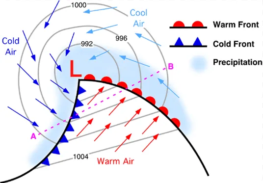
Let’s talk more about low-pressure areas, which very often cause air mass movement. The low-pressure area forms as a result of convective motions, which leads to pressure drop and convergent winds, blowing from outside to inside. Another way to form a low-pressure area is the temperature gradient between two different air masses. It results in creating two noticeable borders between these 2 (or sometimes more) air masses. These borders are a cold front and a warm front (Pic. 43).
The low pressure is related to one very important thing: when the frontal band passes, the air mass obviously changes. Important is the assumption, that the air coming behind the atmospherical front is always clearer than the “older” air being before the frontal band. Better is when the front brings precipitation because the aerosols can be removed from the air easily. It is not a rule, that the air can be more advantageous when the front is much colder. Usually, much colder fronts bring the air with big humidity. In this case, the cloud base level is also low and appreciably reduces visibility. After passing the cold front we get a lowered cloud, which further existence depends on the wind. The slower vanishing of clouds above mountains can make our observation disintegrate. However, not always must be like this. There are many cases, when after the cold frontal band the visibility is appreciably better, except for some isolated clouds with passing rainfalls, and deteriorating atmospherical horizontal transparency in places. It happens usually in three cases: when a cold front passes above the much warmer surface, when frontal rainfall is strong, and when after a cold frontal band wind is strong. The first case refers to the situation, which has been mentioned in the previous section: a much warmer surface causes heating of the air mass, which gets more volume and visibility decreases. On the other hand, we can observe quite strong vertical cloud development with passing rainfalls and thundershowers, which are an effect of steaming from this much warmer surface. The best effect is to be observed when this air mass passes above the sea or lake, then we experience a lake effect with cloudiness and passing precipitation. In these cases, visibility will be often partially impaired by precipitation. A strong rainfall at the cold front zone, clears up the atmosphere from a haze, making it more transparent ultimately. The atmosphere can be also cleared by the strong wind, which blows out any pollutants from the air. Sometimes we experience this situation when after passing a cold front the wind starts to blow strongly. It can be also the time with a nice visual range. To summarize this thing we can say, that the freshest air comes always just behind the atmospheric front, which is a basic principle for long-distance observations.
The low-pressure area brings also a warm section, located between a warm and cold front. During the warm section of the low-pressure area, we can be able to see far. It happens because warm air has less moisture. This situation occurs in the colder part of the year. The warm section should be geographically wide enough however the problem is that the colder front, coming behind the warm one is quicker. The visibility area should be far enough from the cyclone center, where cloudiness and precipitation occur. Better is when the wind in the warm section is stronger otherwise the weather tends to be misty. The air should not be too warm due to steaming.
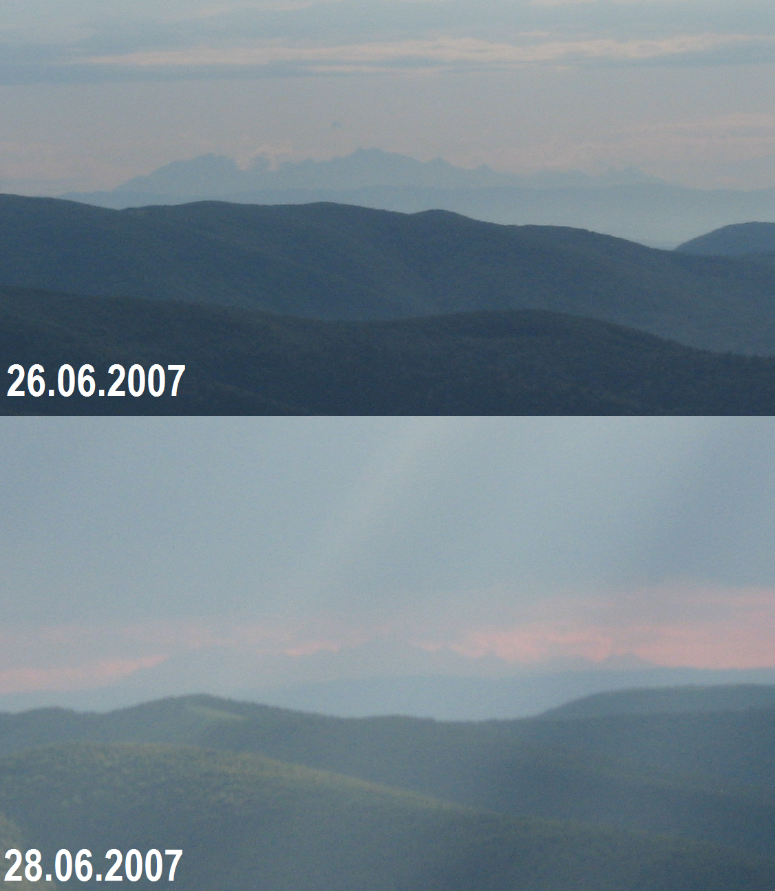
Stable weather for a longer time in some areas causes, that existing air mass transfers and “getting older” to deteriorate the visibility. It also refers to the air masses, that have already transformed into the observed areas like arctic air masses crossing wide steppe areas before an approach to central and southern Europe. Usually, the atmosphere is the most transparent at 1st and sometimes on 2nd day after a fresh air mass approaching (Pic. 44).
In the case of cyclones always the front, from where air mass is coming is clearer than the back. Visibility is also better when closer to the anticyclone center. Favorable conditions provide also pressure increase with the wind when air is mixed. Sometimes it can have a negative side when the wind rises aerosols from the naked ground. The anticyclone presence favors the planetary boundary layer development, where the haze is enslaved and visibility is reduced.
The thermal inversion (typical for the colder part of the year) brings very favorable horizontal visibility conditions, although it may not work for extreme distances. The main role plays the altitude of the inversion boundary (inversion layer thickness), which depends on the pressure level and distance from the anticyclone center. Saying again, it can reach even up to 2000m above ground. Another role plays an age of inversion. Older inversions behave in a different way, the boundary can be fuzzier.
Taking into account the dynamic weather features is very important to check the weather both for the observation place and the object observed, especially at longer distances, which will be explained in the next part of this article. The weather conditions for an observed object are beyond the horizon. For instance, medium-level and high-level clouds can complicate the observation conditions significantly, especially during the light level drop around dawn and dusk (Pic. 40, 41). Sometimes the different weather conditions occur at close distances from the observer. Then watching in the opposite direction we can have two different visibility patterns (Pic. 45).
It is nice when the sufficiently big and stable high-pressure area is located towards the object observed.
Is good to observe the local weather conditions both for surface and certain altitudes due to differences in humidity and cloud level, which I will develop in the next part of this article.
D. HAZE CONCENTRATION
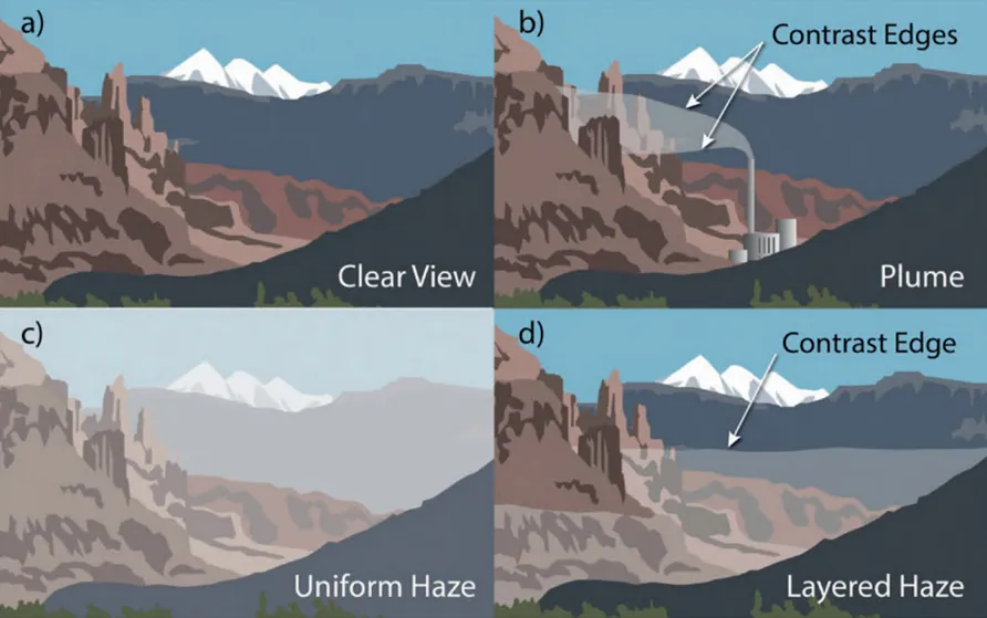
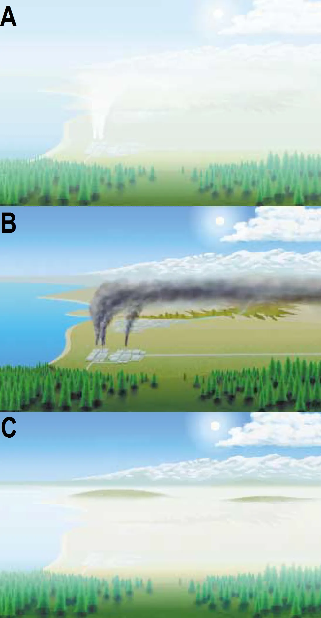
In general, the appearance of the visibility of haze is determined by the concentration and distribution of light scattering and absorbing particles (Malm, 2016). We have 2 basic types of haze (Pic. 46), whereas the uniform haze is much worse because it generally obscures all landscape features in the scene and might be harder to differentiate from naturally occurring background haze (Malm, 2016). Next, to these 2 basic types of haze, we can point also to a plume, which has a layered character and arises out of pollution emission from i.e. chimneys or wildfires, which impair visibility partially on elevated levels (Pic. 47).
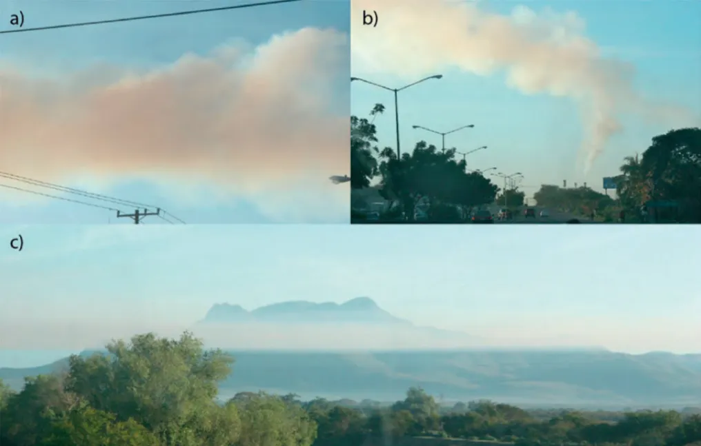
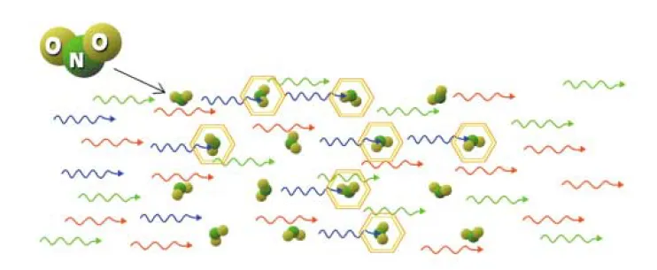
Different pollutants absorb different wavelengths of light. Due to their thickness and local atmosphere stability, we can observe their impact on the vista. For example, black carbon absorbs all wavelengths of light making its plume a dark appearance. Another pollutant, nitrogen dioxide gas absorbs more in the blue than in the red spectrum (Malm, 2016). When nitrogen dioxide combines with varied background illumination, it yields a very brown atmospheric discoloration (Pic. 49). If a volume of the atmosphere contains a lot of nitrogen dioxide is shaded, and if light passes through this shaded portion of the atmosphere, the light reaching the eye will be deficient with photons in the blue part of the spectrum (Malm, 2016). As a consequence, the light will appear brown or reddish in color. However, if the light is allowed to shine on, but not through, the same portion of the atmosphere, scattered light reaches the observer’s eye and the light appears to be gray in nature (Malm, 2016)(Pic. 48, 49, 50).
Depending on the weather conditions (turbulent or stagnant atmosphere) we can point out the three ways, that air pollution can visually degrade a scenic vista (Pic. 50).
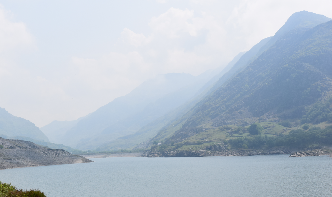
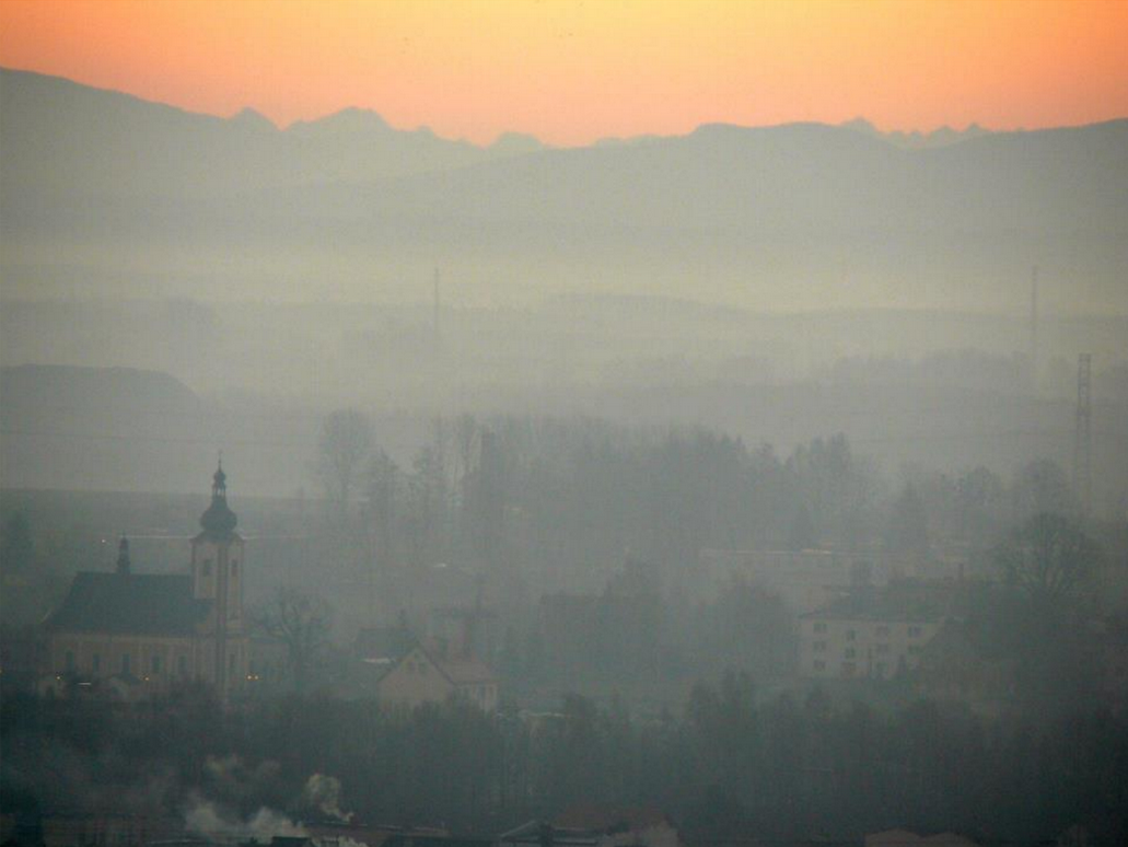
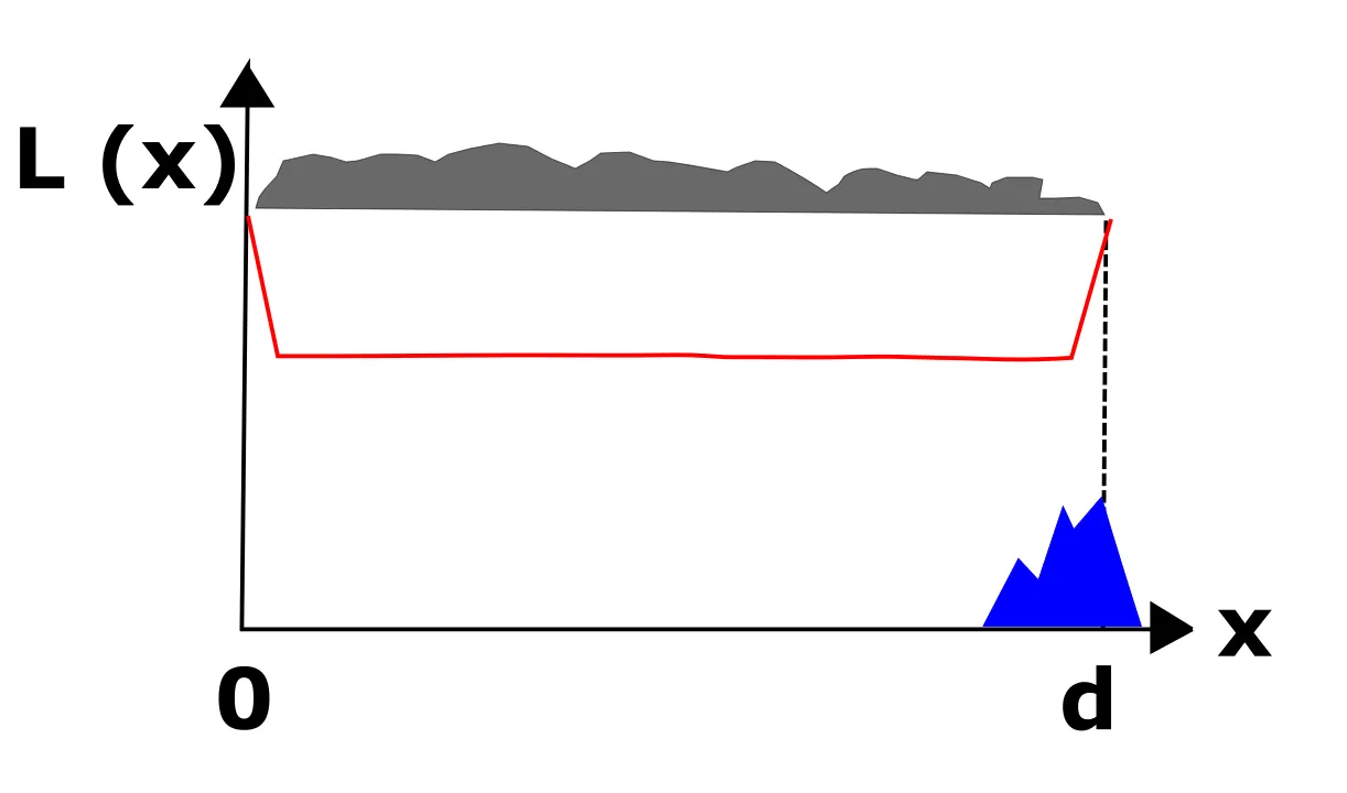
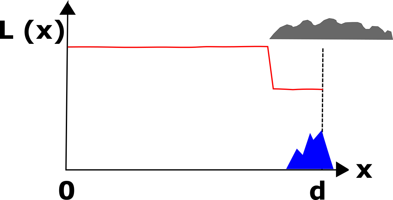
In the layered haze, typical is the contrast edge distinguishing a clear background above from the impaired landscape below. This situation is typical for temperature inversion when haze with (often) air pollutants is trapped near the ground. The layered haze can be misleading for observers being on the side of the layer, where the horizon is partially or even totally obscured unless this layered haze is thin enough to show a pristine view above (Pic. 52).
In the meantime above a few hundred meters view can be completely different with background haze only (near Rayleigh scattering conditions). In this event for people being on the bottom of the basin haze will have a uniform character whereas for mountaineers being above it will appear as a layer.
Naturally, due to the various air masses, we have various levels of uniform haze (Pic. 53).
A uniform haze shouldn’t be confused with a regional haze. The regional haze refers to more to a large spatial scale of visible pollution. The regional haze understanding depends on the geometry and the observer. Above I wrote about the situation when an observer is located underneath the haze layer and is not aware of perfect visibility, above this layer of haze. Here I would like to point, out that the observer, being inside the layered haze can judge the haze to be uniform in that he would not observe a haze with a defined edge (Malm, 2016). When the observer is located above the layered haze, when hiking in mountainous regions, then he is able to see a regional haze in extent, which appears to be layered in the vertical profile.
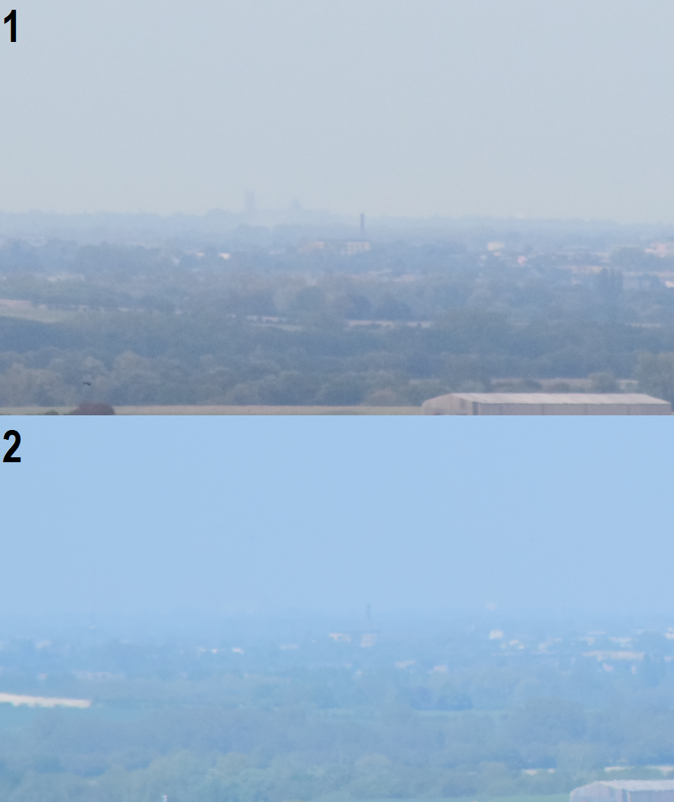
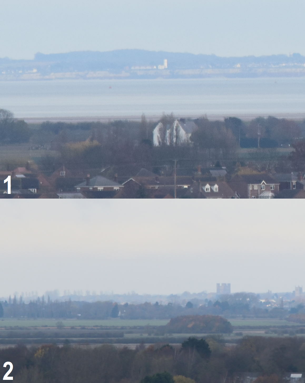
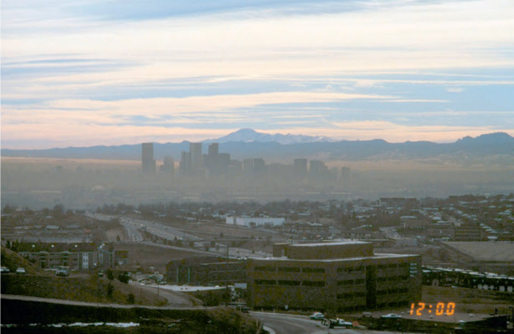
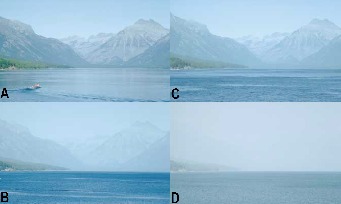
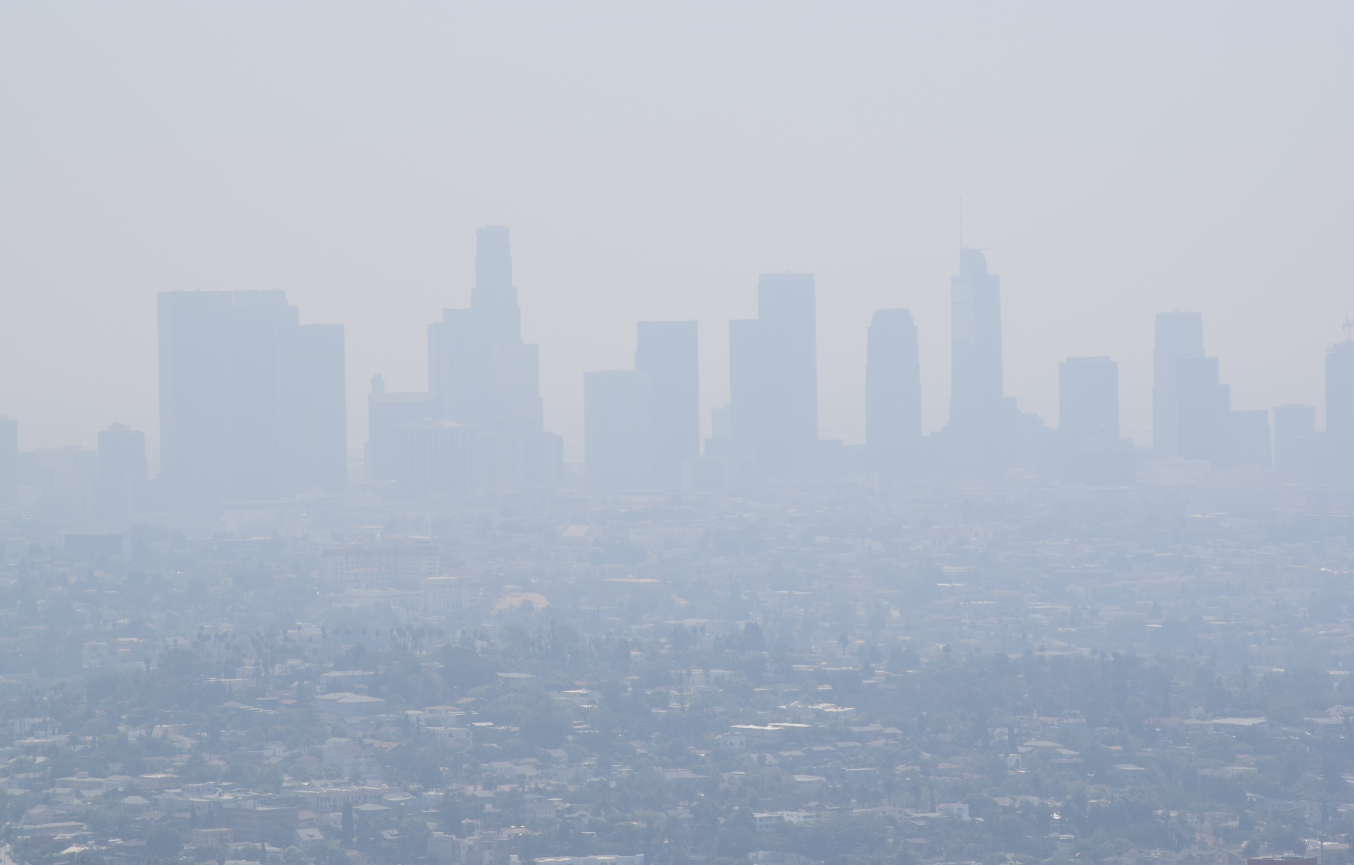
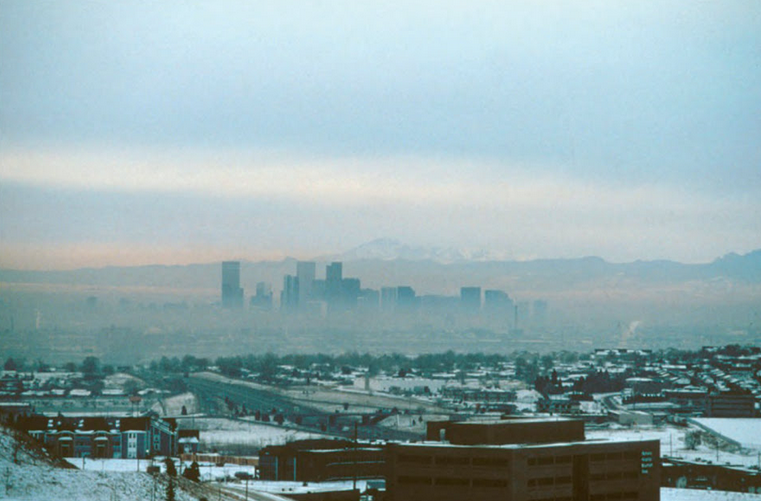
Haze tends to be worse when closer to the ground due to bigger humidity and poor ventilation properties (Pic. 35, 36), which has been raised in the previous section. Also, urban areas with surroundings appear to be hazier due to a lot of emissions. Urban haze is specific, because due to high pollutant concentrations (higher than in non-urban areas) usually impair visibility much more. Sometimes even buildings only a few kilometers distant are substantially obscured (Pic. 55, 56).
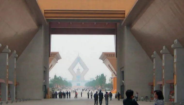
Not to mention, when haze is sufficiently dense to obscure features that are only a few meters distant. In thermal inversion conditions, when layered haze is observed in urban areas the highest skyscrapers can extend up through the inversion layer giving very good visibility conditions (Pic. 57). Another haze information has been described in my previous article.
2.3 OPTICAL FACTORS
A. LIGHT SCATTERING
There are three major factors determining a visual range by light scattering: astronomical, haze, and cloud coverage. From the astronomical point of view important is the solar position in the sky, which has been described in the second chapter. However, there are still a few issues, which I must raise in this section. I was writing about visibility towards solar and antisolar points. I will remind you that in the antisolar direction, the distant objects are better visible in daylight because the backward scattering doesn’t reduce the visibility as strongly as forward scattering (Pic. 58). Besides these objects are usually not shaded by themselves, giving an observer a chance to see some elements of their relief instead of outline only.
The situation changes rapidly just after sunset when the twilight wedge (belt of Venus) becomes visible. Then these objects became much less visible due to vanishing the contrast between sky and ground and the fast decreasing of background luminance (Pic. 16, 18). As the dusk progresses, the twilight wedge engulfs more and more of the sky with the horizon. Finally, the angle of visibility in a bright atmosphere decreases to more or less 180 deg during the civil twilight to be completely gone at nautical twilight (Pic. 11, 12, 18, 60, 61).
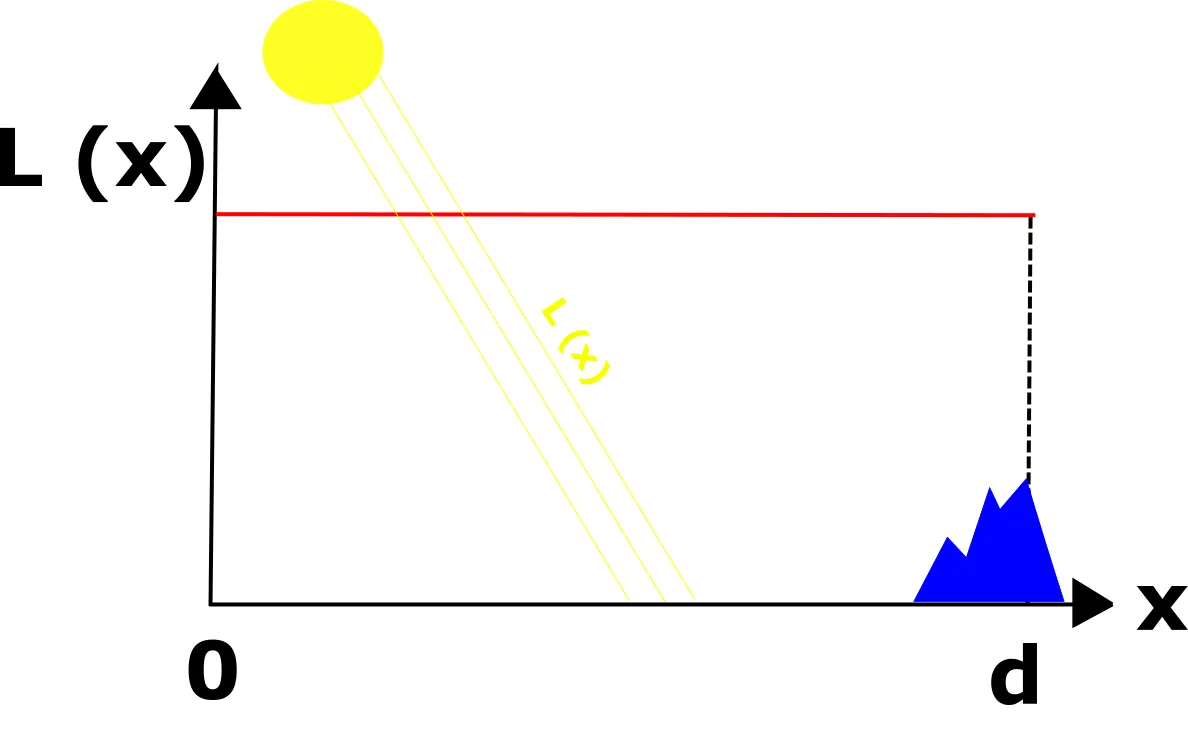
Light scattering is important also during the day. Sunlight, ground-reflected light, and light reflected by other objects (like clouds) are scattered by the intervening atmosphere into the sight path. Clouds play also a different role in visibility conditions. They can extend a visual range through the block of direct sunlight and decrease the light scattering at once. When the sky is covered by thick clouds then some parts or at least one part of the line of sight is shaded by them. It incurs a nonuniform solar illumination alongside the path and inhomogeneous irradiation of the atmosphere. The molecules and aerosols being in the line of sight have a different incident solar radiance. The illuminated ones scatter light more efficiently, on the contrary to shaded aerosols, which have a weaker scattering. Every shaded section present alongside the line of sight appears to reduce the solar light scattering then. It is strongly related to the light transition phenomena, wherein shaded regions have less amount of light to scatter. At the same time, the distant horizon is illuminated by strong sunlight, which makes an excellent contrast with shaded regions. This is an event, when stronger light, coming from an illuminated part of the sky beat up much weaker light coming from the shaded object, making it invisible. It happens only if a distant horizon is unobstructed by thick clouds because otherwise, the view won’t be good. Thick clouds determine a perfect light diffusion, which is next radiated uniformly in all directions (Houghton, 1939).
We can list basic five situations, in which the line of sight between an observer and a distant object is partially shaded. More details about it show the mechanism and practical proof below. The majority of these situations are contributing to reducing the attenuation of light reflected from a remote object making it more visible to an observer.
Under clear skies, there is no difference between illumination throughout a whole line of sight (Pic. 62).
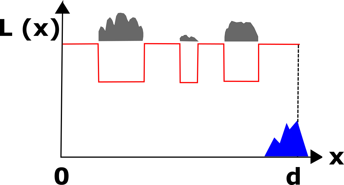
Sometimes, when the sky is covered by a lot of patches of clouds a line of sight between an observer and a distant mountain can be shaded even a few times (Pic. 63). On this occasion the vista appears to look slightly better, than under clear skies, however, it is still not clear enough due to strong light scattering in places.
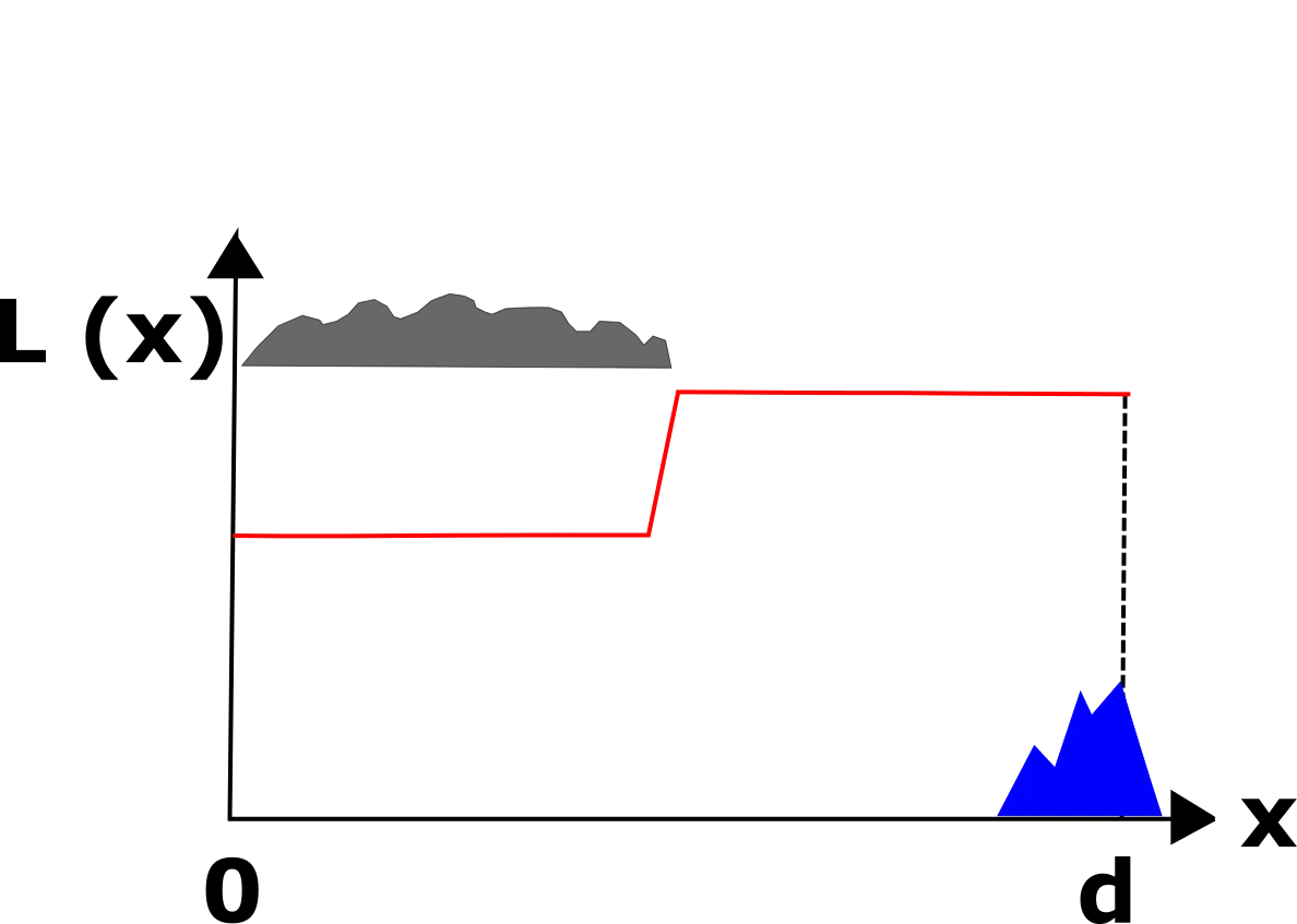
When the sky at the observation point is cloudy and the sun is shining on the distant object far away (Pic. 64), then the visibility conditions are slightly better, but not perfect. They depend roughly on the part of the line of sight, which is being shaded. Usually far, illuminated mountains can merge with the illuminated sky, when a haze concentration level is high.
The best situation for distant object observation is cloud cover located at the path between an observer and object (Pic. 65), which blocks the sunlight both at the observation place and a remote place observed, however, the sky just above the horizon remains clear and bright. Then the contrast with the sky beyond is the best, giving much better visibility conditions. One drawback is, that observers can see an outline of this distant object only without any details because they are being shaded.
The worst situation (Pic. 66) is when cloudiness appears at the same azimuth with a distant object observed and covers all lower parts of the sky down to the horizon. Then only a “grey wall” of clouds is to be seen. An object, even in good visibility conditions can be merged with these clouds, especially when shaded by them. If not, it will be capable of reflecting some sunlight from its brighter parts (e.g. grassland, snow cap, etc).
B. LANDSCAPE (OBJECT) FEATURES
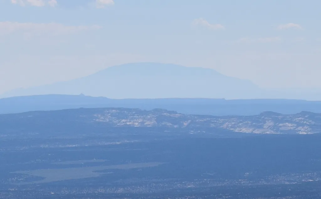
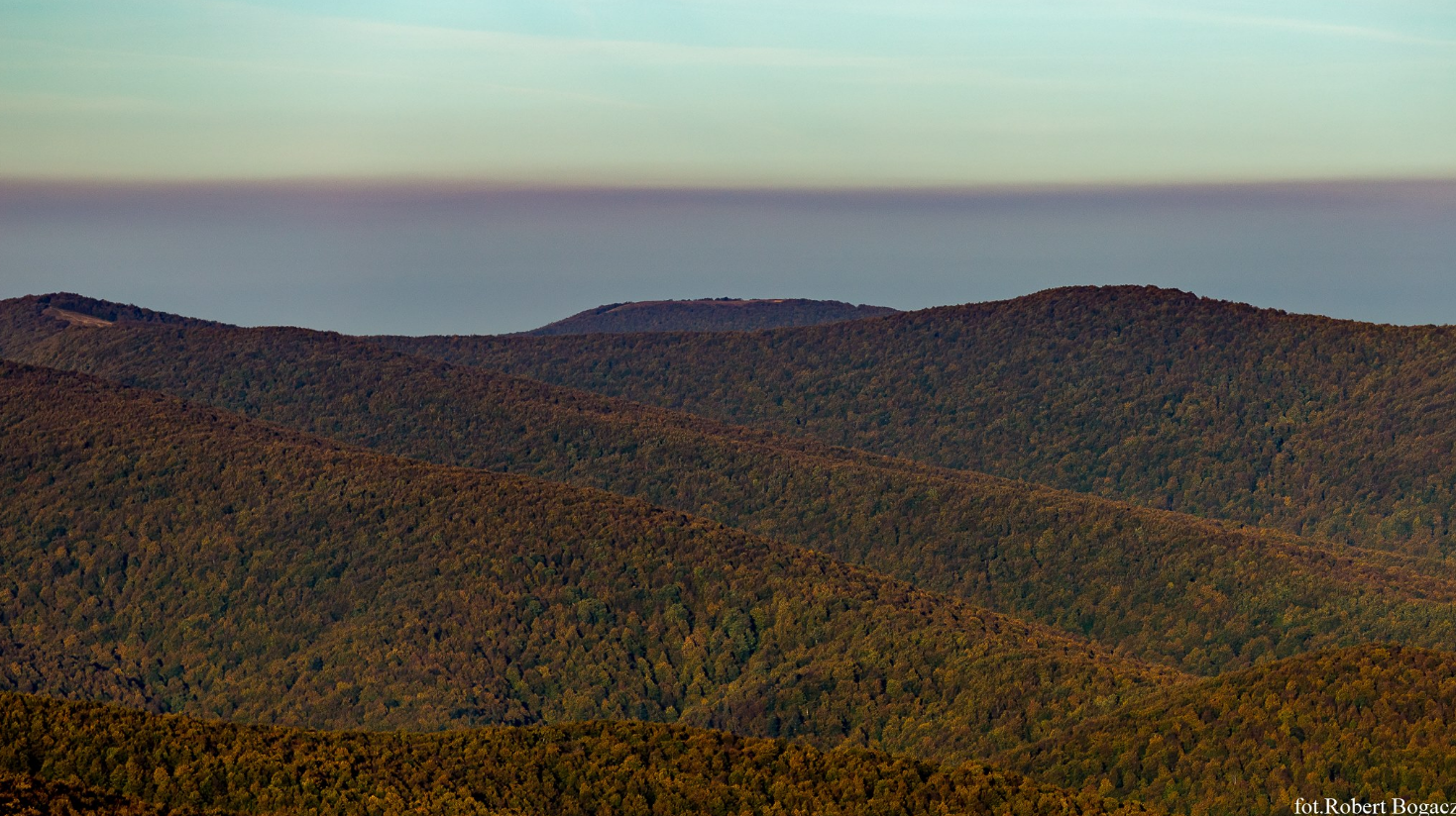
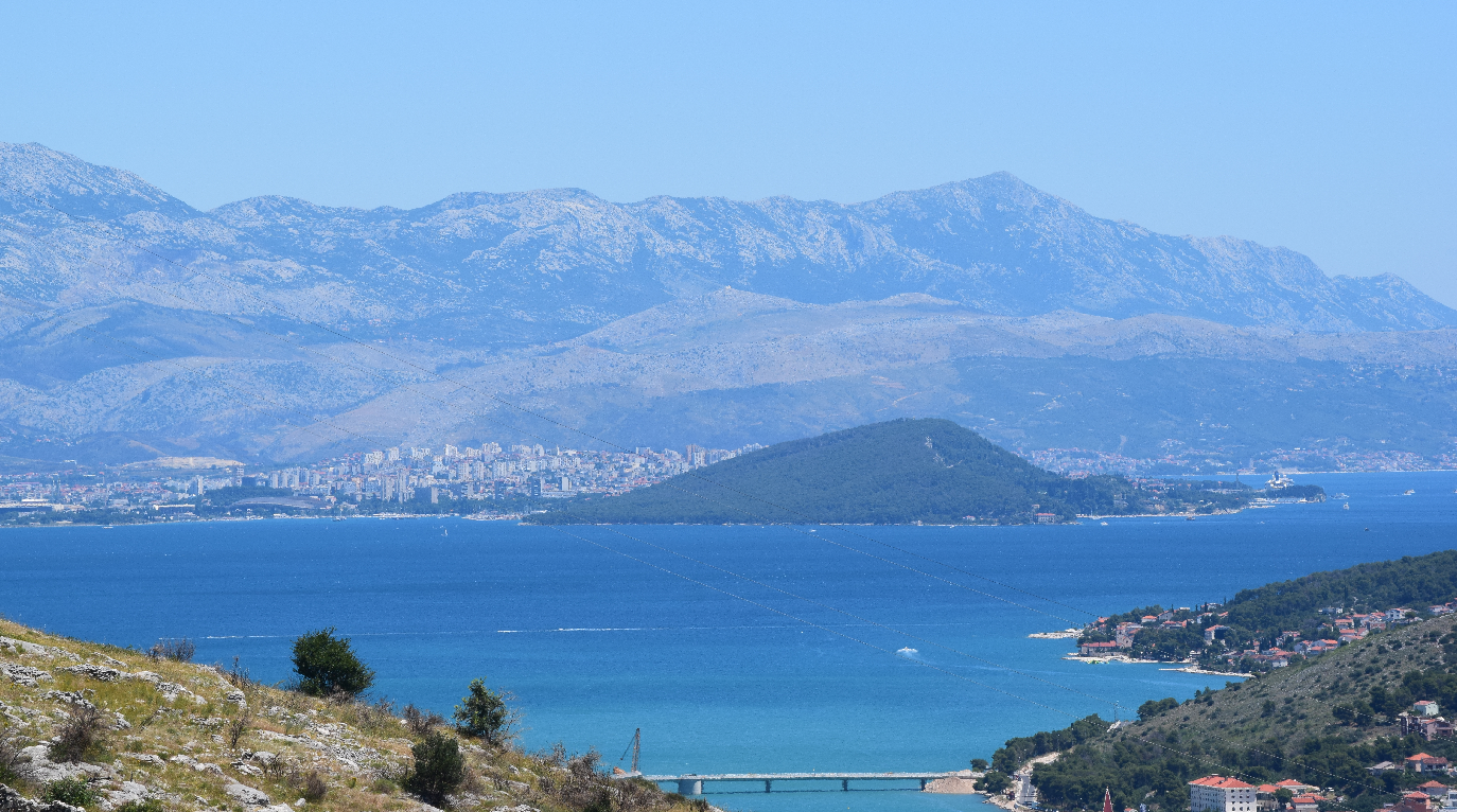
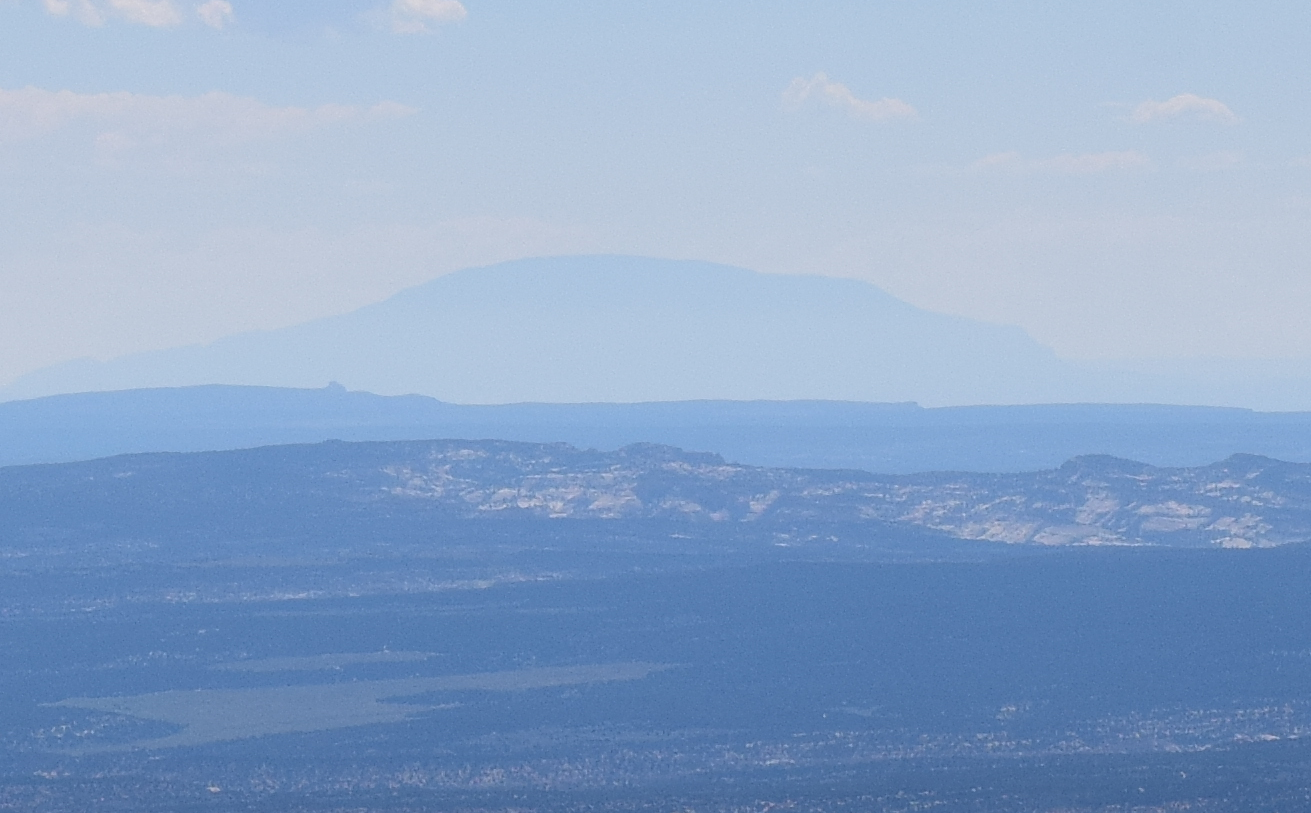
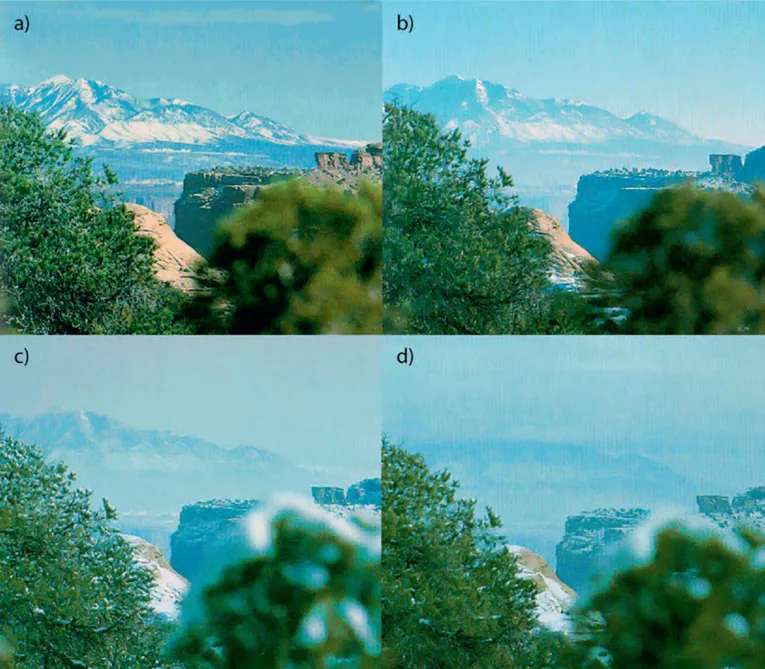
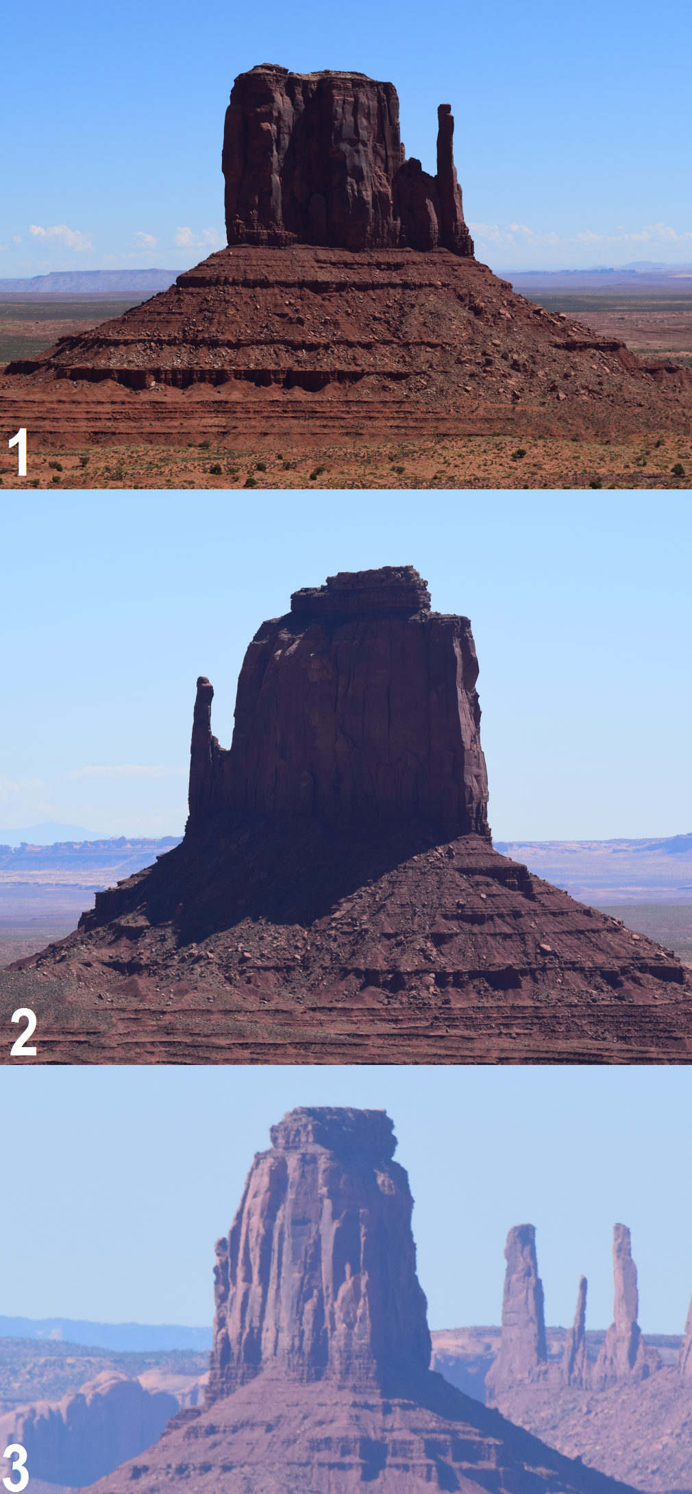
The landscape features include color, texture, form, and brightness (Malm, 2016) as well as the anthropogenic feature. The form is to be the easiest way to recognize the remote object. The best example is between the lower and higher mountains. Lower mountains appear like domes, beacons, or buttes whereas high mountains can be seen like high sharp and steep objects. Color and texture are also important in the case of mountains. When peaks are snow-capped usually will be slightly easier to spot them far on the horizon despite the fact, that snow has the biggest albedo. A good example is the picture below, where snow-capped mountains, located at about 110km distance are barely visible under high haze concentration conditions, thanks to snow coverage (Pic. 68).
The best moment to recognize these peaks is in the early warm part of the year when the highest parts of the mountains are patched with snow. The color pattern of the landscape is strongly associated with its brightness. Brightness enables the object to be more or less visible. When the object’s surface is brighter then the sunlight is reflected more effectively. The reflected beam from this object is stronger and more capable of reaching the distant observer (Pic. 70).
The anthropogenic feature states whether the object is emitting light (during the night) or reflecting the light (in a favorable solar angle some skyscrapers can perfectly reflect the sunlight for long distances) (Pic. 71).
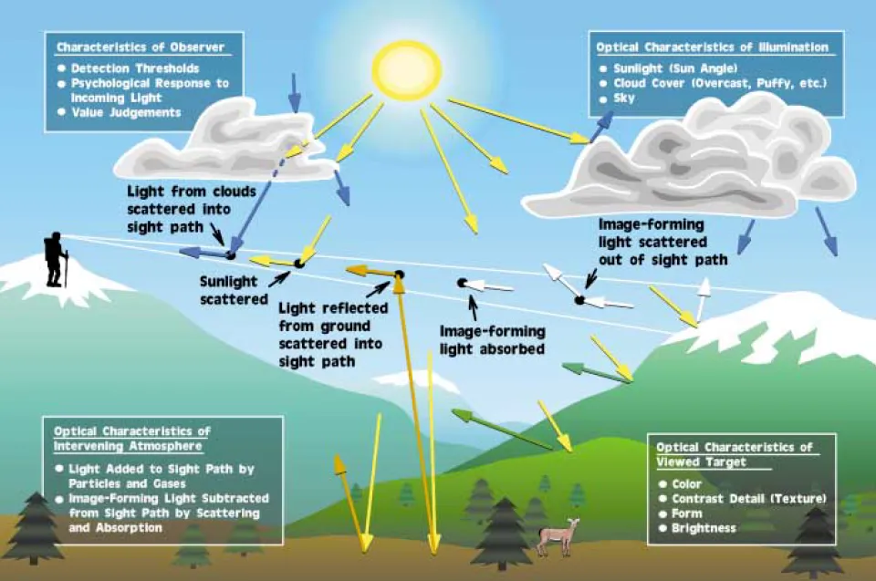
Another optical issue arises out of the intervening atmosphere. Image-forming information (radiation) originating from landscape features is scattered and absorbed (attenuated) as it passes through the atmosphere toward the observer (Malm, 2016).
To summarize this section as well as a light scattering issue let’s have a look at the schematic below (Pic. 72):
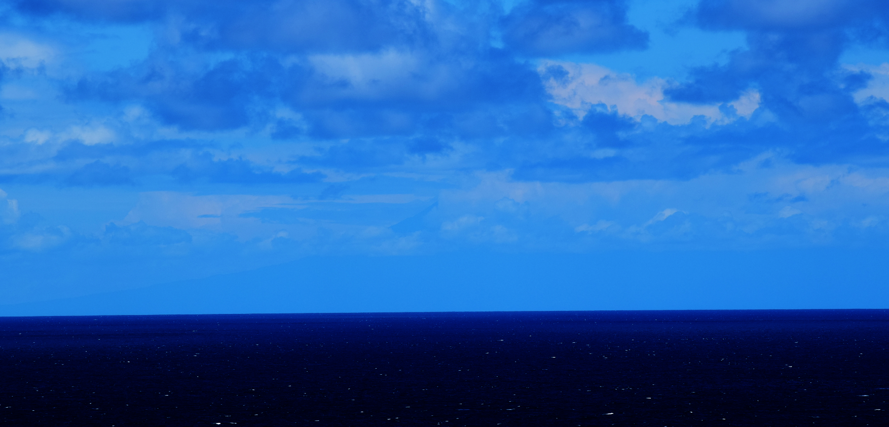
C. WHY DISTANT HORIZON APPEARS TO BE BLUE?
The blueness of the sky has been briefly described in this article and also on this occasion.
The blueness of the horizon is caused by the smallish part of the air-tiny hydrocarbon particles released by vegetation, that chemically react with ozone molecules. In the outcome, the blue light is scattered selectively and gives the mountains, and remote objects a blue appearance. You can always notice even when visibility is perfect and your target is not very distant. Despite many details of its surface, it will have a bluish appearance (Pic. 73). Another explanation comes from the diffuse sky radiation, which scatters mostly the short wavelengths, which is also translated into the air molecules giving the bluish appearance. It changes slightly when the Sun is near the horizon, where longer wavelengths are scattered.
When visibility is worse the objects appear to be bluer i.e. due to nitrogen dioxide gas concentration. If a volume of the atmosphere containing NO2 is shaded and if light passes through this shaded portion of the atmosphere, the light reaching the eye will be deficient in photons in the blue part of the spectrum (Pic. 47,48,49). As a consequence, the light will appear brown or reddish in color (Malm, 2016), which has been discussed in the previous section.
Mariusz Krukar
References:
- Ackerman S.A., Knox J. A., 2007, Meteorology: understanding the atmosphere, Thompson higher education, Belmont, CA.
- Bennett A., 2016, Introduction to atmospheric visibility estimation, (in:) Visibility sensors, Bristol Industrial & Research Associates Ltd. (Biral)
- Horvath H., 1967, Atmospheric visibility, (in:) Atmospheric Environment, vol. 15, i.10-11, p.1785-1796
- Houghton H.G., 1939, On the relation between visibility and the constitution of clouds and fog, (in:) Journal of the Aeronautical Sciences, vol. 6, no 10, p.408-411
- Hyslop N.P., 2009, Impaired visibility: the air pollution people see, (in:) Atmospheric Environment, vol. 43, i. 1, p.182-195
- Luranc G., 2012, Wpływ sytuacji synoptycznych na widzialność w województwie małopolskim, Master dissertation, Faculty of Biology and Earth Sciences, Jagiellonian University (Polish)
- Majewski G.,et.al, 2015, The impact of selected parameters of visibility: First result from long-term campaign in Warsaw, Poland ,(in:) Atmosphere, v.6, p.1154-1174
- Malm W.C., 2016, Visibility: The seeing of near and distant landscape features, Elsevier Inc., New York
- McGraw-Hill Dictionary of scientific & technical terms, 2003, The McGraw-Hill Companies Ltd.
Links:
- Vertical visibility – the Free Dictionary explanation
- Vision
- The Sun angle calculator
- Aerosol optical depth – AERONET archival data
- MetOffice: Air-masses-and-Fronts.pdf
- Flightlearnings.com: air-masses – explanation
- Onlinelibrary.wiley.com: Air masses – rough explanation
- Equatorial air mass characteristic
- https://geology.com/world/europe-physical-map.shtml
- Convection vs subsidence
- Types of inversion
- Plume Blight
- Naobzore.net: atmospheric fronts (Slovak)
- Dalekie Vyhlady a mozlivosti ich pozorovania (Slovak)
- How far away is the horizon?
Wiki:
Read also:
- What is a light transition? What examples can we see?
- Why the haze is an important weather factor, part 1 – types of aerosol and impact on human health
- Why the haze is an important weather factor, part 2 – impact on visibility and light scattering
- Light scattering in the Earth’s atmosphere, part 1 – scattering and related phenomenas
- Light scattering in the Earth’s atmosphere, part 2 – why is the sky blue and how the sky colour change?
- Light scattering in the Earth’s atmosphere, part 3 – clouds, haze and surface