The quickest decimal to DMS convertion in Excel

Coordinates DMS to decimal and decimal to DMS one cell only Excel

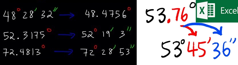
Suppose you work on geographical or astronomical projects requiring transformation between the decimal and degree-minute-second pattern. You probably want to have everything converted as quickly as possible. On the web, some tutorials explain that the most common solution is using the Data -> Text to Columns with the main ribbon. Another way presented in the … Read more

Clever way of batch converting Latitude/Longitude to Ordnance Survey XY in Excel

Converting Lat/Lon to OSGB in Excel

The Ordnance Survey grid conversion is usually required when dealing with some projects across the UK. Usually, along with the standard WGS 84 datum, we need to define X (Easting) and Y (Northing) coordinates. This task might be quite time-consuming when converting our locations one by one. Fortunately, we have some tools, which can do … Read more

Digitizing administrative maps in Google Earth

Google Earth digitizing maps

The digitizing process is needed when we want to transform our map into vector data. This process is aimed at tracing the map features, which later appear as coordinates in either point, line, or polygon format. Digitizing is essential in the case where our data cannot be instantly integrated with the other GIS data. In … Read more

How to show the coordinate grids in Google Earth and Google Maps?

Google Maps MGRS

There are a few ways to show the coordinate grids on Google Earth. The easiest way to show the coordinate grids in Google Earth is to select “Grids” from the “Tools” options. Then you will have full zoomable coordinates grid cover (Pic 1 – 3). The default coordinate system bound to Google Earth is the … Read more