
In this article, I would like to try to answer the question in the title. I based my suggestions on the last weather patterns, that used to happen in the Mediterranean region for the last several autumnal periods. Besides I was (un)fortunate to experience similar weather phenomena during my stay in Mallorca in December 2016. The Mediterranean tropical-like cyclones are called also Medicanes. They can appear mainly just after the summer period because this is the best time when the main factors come through.
1. MEDICANES – MEDITERRANEAN TROPICAL-LIKE CYCLONES
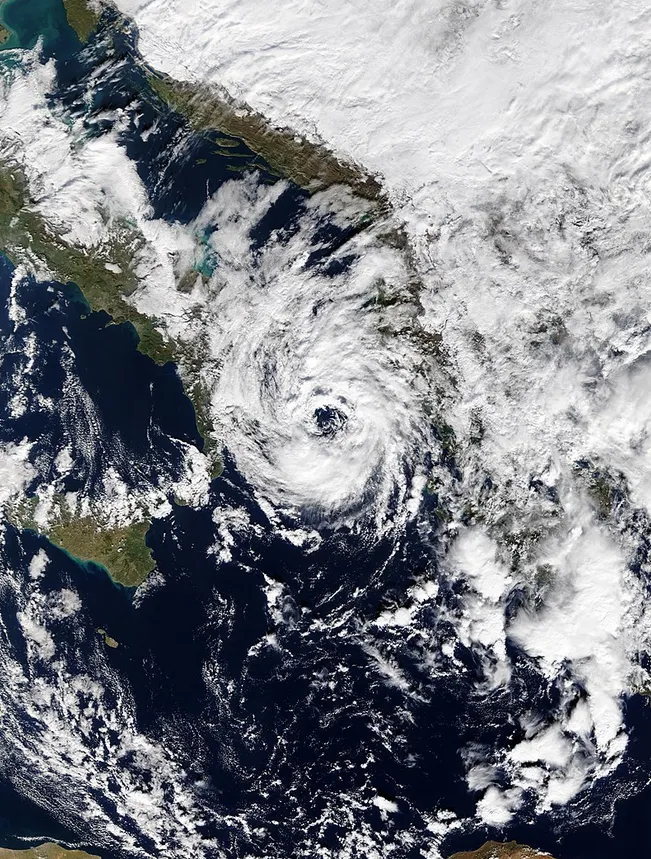
Medicanes or Mediterranean tropical-like cyclones are cold-core cyclones developed over the Mediterranean Sea (Jansa, 2003), that often closely resemble tropical cyclones in satellite images. These cyclones with tropical and subtropical characteristics can produce severe winds and torrential rainfall with major floods in affected areas Well developed medicanes have tropical characteristics, with clear circular eyes, surrounded by an eyewall and cloud pattern. Like hurricanes, medicanes cause sudden pressure and wind changes in the affected areas, but they normally do not reach the same intensities (Tous, Romero, 2011).
2. FORMER CYCLONES
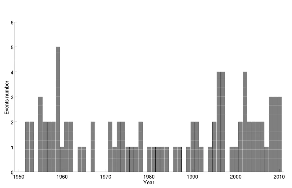
Tropical-like systems were first identified in the Mediterranean basin in the 1980s by widespread satellite, however, this type of storm was known in the region earlier, since ancient times. Between 1947 and 2011 there were around 100 recorded tropical-like storms, where most of them were below tropical storm intensity. During this period several notable and damaging Medicanes, caused extreme flooding and the death of several hundred people. The strongest system resembled tropical cyclones as observed in tropical zones. The most remembered is the medicane, which occurred in September 1969. This cyclone produced severe flooding throughout the region of northern Africa. In Tunisia, the cyclone flooded phosphate mines and many wildlife and populated areas. Thousands of camels and snakes, drowned by floodwaters were swept out to sea. On top of that massive Roman bridges, which withstood all floods since the fall of the Roman Empire, collapsed. This massive storm killed 600 individuals and left another 250000 homeless. Medicanes, which occurred in later periods were not as strong as the ones from 1969.

3. DEVELOPMENT AND OCCURRENCE
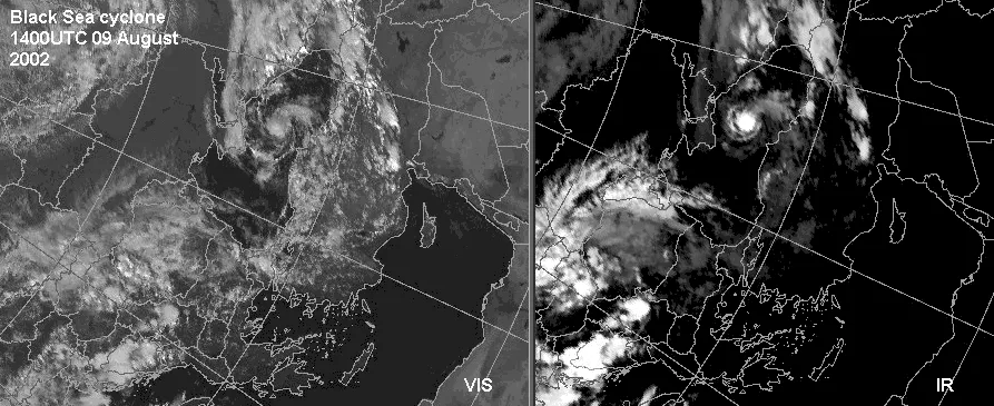
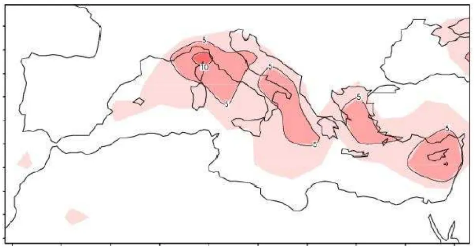
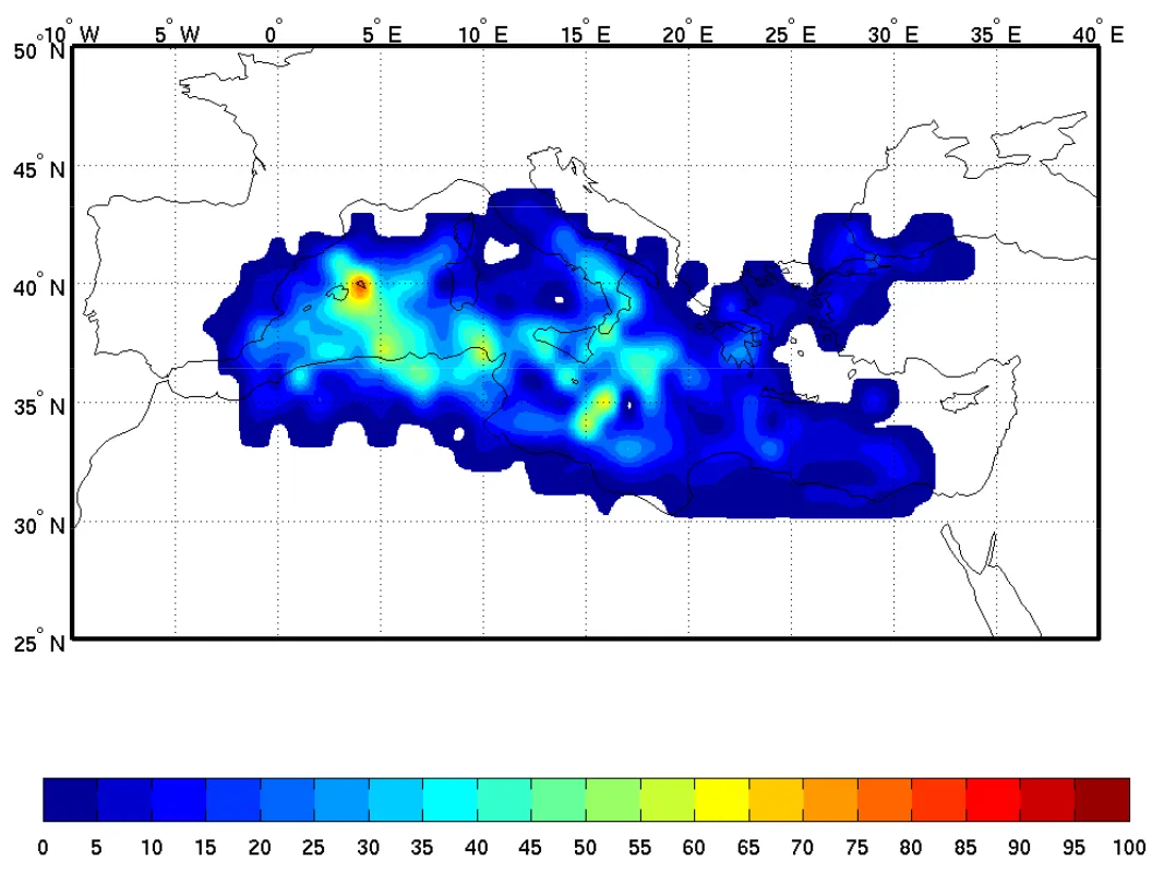
To answer the question of what are the main factors to develop Mediterranean tropical-like cyclones we should take a look at the geographical location of the Mediterranean Sea. First of all the sea lies inside specific orographic structures, such as high mountains i.e. Alps, Pyrenees, Atlas, or Appennines. These mountain ranges may trigger airflow to vortex development. Due to its complex orography, the Mediterranean region exhibits a great variety of subregional weather features, that influence the intensity and frequency of medicanes appearance. It was found, that there are two areas, where the larger number of medicanes is formed, the western Mediterranean and the “Ionian” regions (Cavicchia, von Storch, Gualdi, 2013). The occurrence of medicanes in the Mediterranean Sea is generally rare, with an average of 1.57 forming annually (Cavicchia, von Storch, Gualdi, 2013). Except for the most common region of occurrence, cyclone-like storms can develop everywhere in the Mediterranean region, even in the Black Sea (Pic. 4).
The development of tropical or subtropical cyclones in the Mediterranean Sea can occur under somewhat unusual circumstances. What is interesting, the sea surface temperature is not the main development factor like in the case of normal tropical cyclones. Whereas tropical cyclones require temperatures of around 26 degrees Celsius to grow, medicanes have been known to evolve in waters as cool as merely 15 degrees Celsius. In the case of medicanes, the sea surface temperature is not a primary agent then. Hurricanes form around a warm core and move from east to west, whereas medicanes have a cold core and travel from west to east. According to studies carried out over the last several years, the primary factor causing the medicanes is a cold air intrusion in the upper atmospheric levels, which causes the anomalies of the temperature difference leading to instability of the pressure. When this instability is sufficient, then a storm can be created. Initially, this is a deep cyclone with a cut-off (closed circulation at a high level, extended to the surface) and cold-core (where the interior isotherms are cooler than outside) forming in the middle and upper troposphere, from the “break” of Rossby Waves (Tous, Romero, 2011). When this huge low-pressure area is formed above the Mediterranean or close to it, the air of the lower layers rises, generally through large vertical movements, the air is cooled and its relative humidity rises until reaching saturation and releasing (perhaps massively) condensational latent heat. It, therefore, becomes a system that could lead to the evolution of a medicane (Tous, Romero, 2011). Medicanes, unlike their tropical counterparts, are able to take better advantage of heat from the air, not only from the sea. It arises out of the higher latitudes, where the Coriolis force is stronger and the tropopause is lower. Other favorable conditions to develop a medicane are low wind shear, ambient moisture, and vorticity. Unlike most northern hemisphere cyclone seasons, Mediterranean tropical-like cyclone activity peaks between the months of September and January. The biggest likelihood of the formation of the medicanes falls in September, due to warm sea surface water. The relative warmth of the sea during autumn associated with high relative humidity may trigger the development of Mediterranean tropic-like cyclones, having a significant impact on the sea and coastal regions (Nastos et al., 2015) (Pic. 5).
Another peak in the annual cycle of medicane formation falls at the beginning of winter in December. The probability of having conditions favorable for medicanes development is higher in the northwestern part of the sea. Next to this region, also above the Adriatic and Aegean seas, the medicanes can form. Their development in these areas is restricted because both Adriatic and the Aegean Seas are semi-closed, most of the low-pressure systems crossing them stay over a sea for a short time. All these seas lie in the northern part of the Mediterranean basin, being first affected by cold air masses. Contrary to the Balearic region, the Ionian Sea is the first in the eastern part of the Mediterranean, where the medicanes can fully develop. The last area with a high probability of medicane development is the North African coast.
4. THE MEDITERRANEAN TROPICAL-LIKE CYCLONE CHARACTERISTIC
The medicanes are similar to tropical hurricanes because they feature the existence of a well-defined eye with cloud mass deployed symmetrically. This cloud mass is continuous, but not as big as in the case of tropical hurricanes. The diameter of the Mediterranean tropical-like cyclone doesn’t exceed 300mm. The deep low-pressure system is classified as a medicane if it shows vertical symmetry and a warm core for more than 10% of the track or more than six hours (Cavicchia, van Storch, Gualdi, 2013). The same requirement applies to the minimum average wind speed within the circle of radius 50km around the pressure minimum: V = 18m/s. On the other hand, the maximum wind speed in this area should go beyond V = 29m/s for at least 4 hours. Moreover, once the wind speed at 850 hPa is bigger than at 300 hPa, then we can say about medicane. The primary energy source utilized by Mediterranean tropical-like cyclones is derived from underlying heat sources generated by convection – a thunderstorm activity in a humid environment, which is typical for all tropical cyclones elsewhere outside the Mediterranean Sea (Tous, Romero, 2013). While ordinary winter storms are baroclinic in origin, medicanes operate on heat, which is released in a convectively driven cloud system rooted in a continuously moistened boundary layer (Tous Romero, 2013). The typical medicane duration, as has been reported was between 6 and 72 hours, so unlike tropical cyclones, medicanes dissipate quickly (Pic. 9).
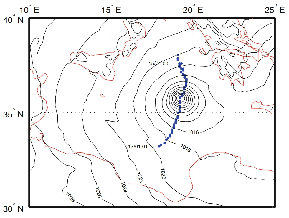
Most medicanes maintain a radius of 70 to 200 km, last between 12 hours and 5 days, travel for 700 to 3000 km, develop an eye, be visible for as long as 3 days, and feature wind speed of up to 144km/h. In some cases, the eye does not appear, whilst others can appear twice until the storm hits the land. The Mediterranean tropical-like cyclones have worse conditions to develop than other tropical cyclones due to the relatively small size of the sea basin. Next to the restricted Mediterranean Sea area, the region features a lot of peninsulas and islands. These areas of land create a barrier to cyclone development and reduce their lifetime. Medicanes have less time to increase their intensity. The theoretical maximum potential intensity of Medicanes is equivalent to a category 1 hurricane. Even, when the entire lifetime of this cyclone may encompass several days, most will only retain tropical characteristics for less than 24 hours (Miglietta et all, 2013). A typical Mediterranean tropical-like cyclone undergoes three phases in its lifetime:
- Pre-eye where most of the cyclone is occupied by strong convective activity,
- The stationary phase with a fully developed cyclone having an eye surrounded by the axisymmetric structure of clouds, strong winds, thunderstorms, and heavy rainfall,
- The itinerant phase is characterized by the fast, directional motion of medicane with weaker rainfalls and stronger, more severe winds.
A medicanes occurrence is not a sparse example of tropical-like cyclones developed on colder sea surfaces. There are other examples of analogous cyclones, the polar lows known to develop over high latitude oceans.
5. MALLORCA, DECEMBER 2016 STORMS AGAINST OTHER NOTABLE IMPACTS
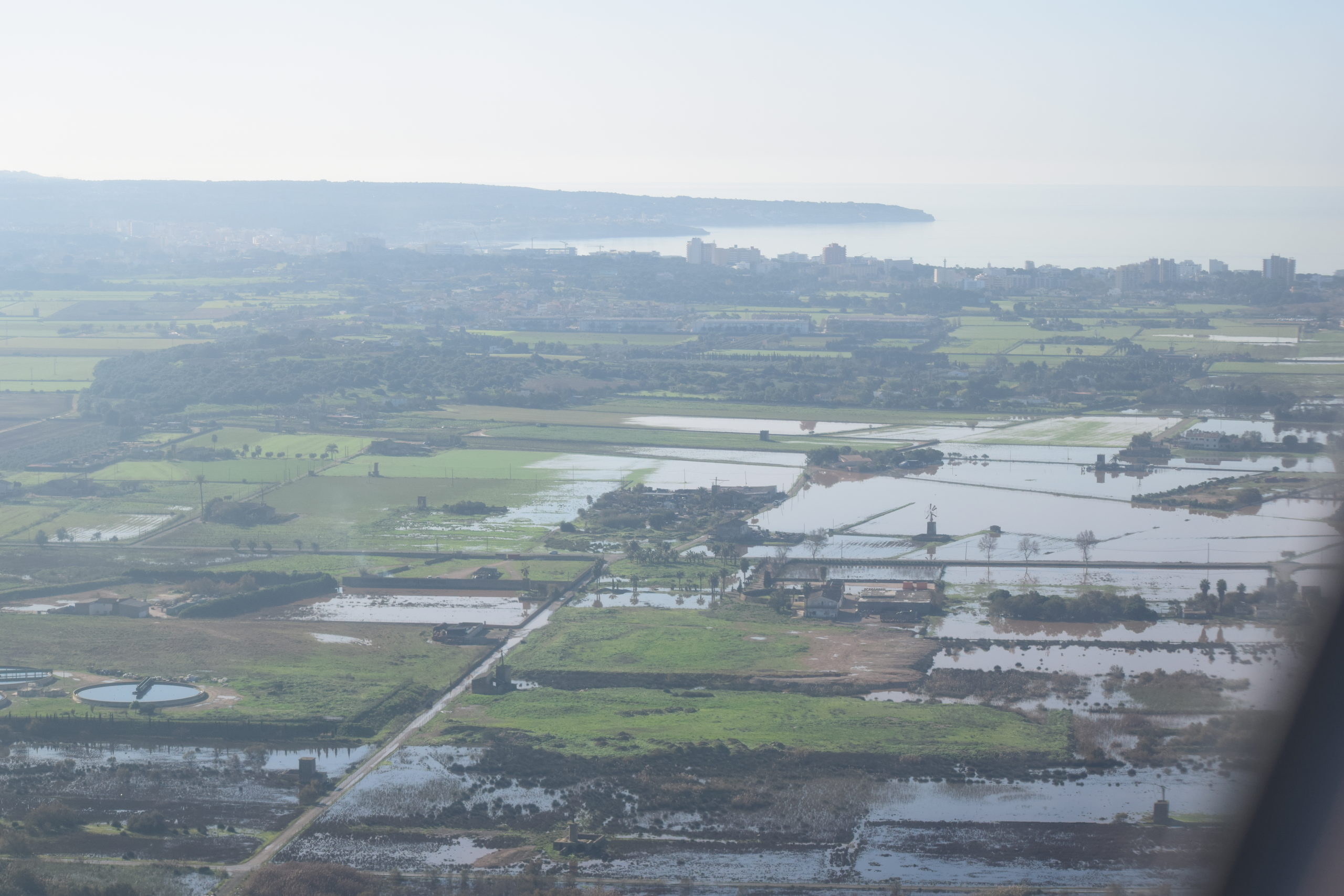
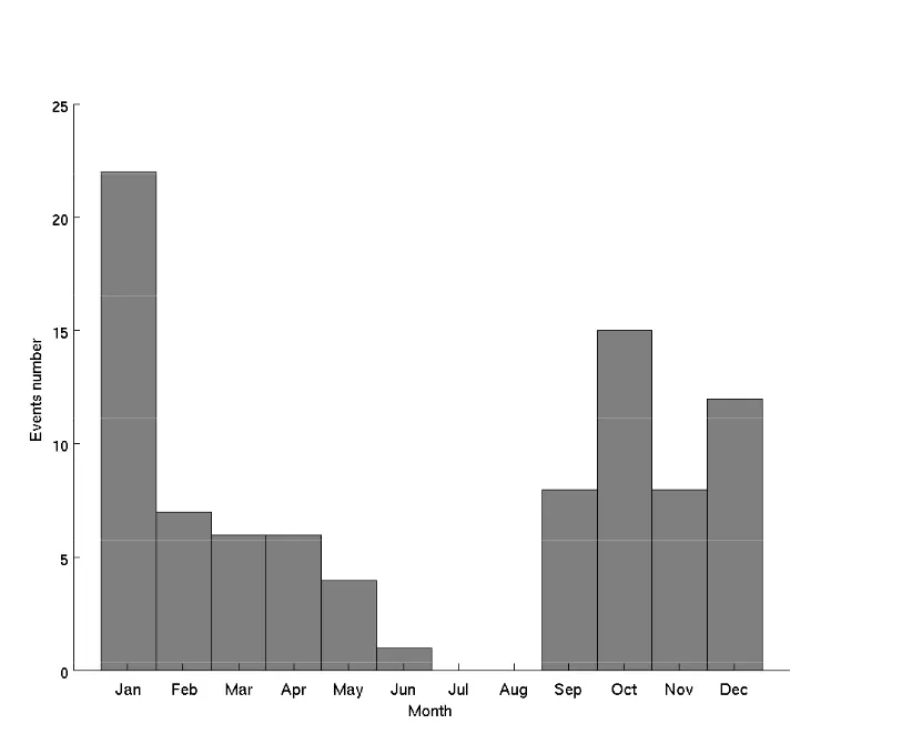
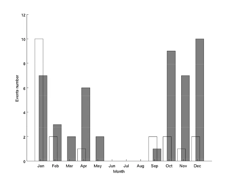
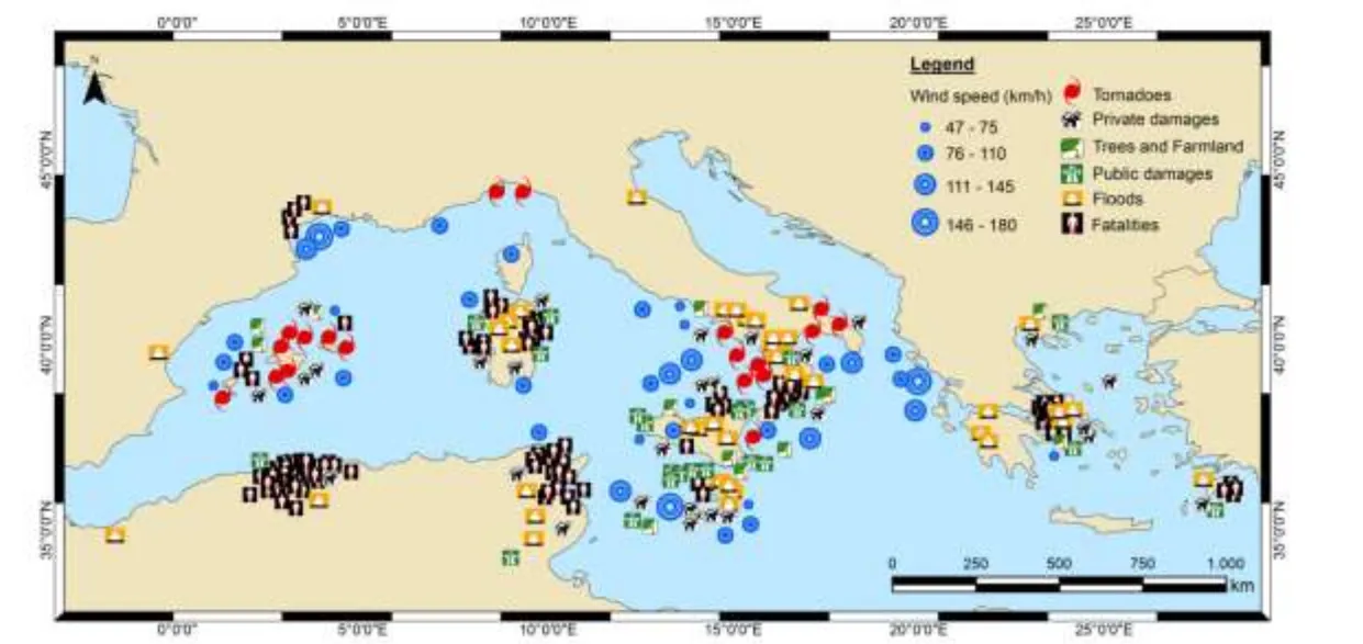
The cyclone, that developed in mid-December at Balearic Isles was not a Mediterranean tropical-like cyclone, however, I picked this storm up to describe its severity. Aside from rare medicanes occurrences, the Mediterranean region in autumn and winter months is reaching a large number of intense cyclones. Annually, an average of 47 intense cyclones are generated in the Mediterranean, representing 6,2% of all cyclones generated in the Mediterranean (Tous, Romero, 2011). The intense cyclones bring torrential rains and thunderstorms, which cause flash floods and flooding in general. Except for the medicanes and intense cyclones, there are a number of small and exceptionally severe storms I have been unfortunate to see one of the examples of this kind of weather during my holiday in Mallorca. The bad weather began on Saturday 17 December, when the cyclone emerged in the southeastern part of Spain, causing big flooding in forthcoming days. In the aftermath, 2 people died and another several were injured. At Mallorca, the weather started to worsen on Sunday afternoon, when thunderstorms entered the island from the south. There were a few thunderstorms observed before the evening, which passed one by one. The worst was at night and Monday morning. In the effect of this severe weather there were about 150 incidents, fortunately not serious enough. The emergency was called for pumping out flooded buildings and clearing fallen trees. The worst affected area was Campos. The thundery weather caused a flash flood in many places across the island (Pic. 10-18). Due to this, at least a few main roads had been cut off. In some areas, vehicles had to be dragged from flooded roads, while others were left by their drivers as they became submerged in the floodwater. Aside from flooded roads many crops and draining systems had been damaged. In other places, water had brought down dragged debris across recently sown fields. Over the afternoon hours, the weather improved, bringing the sun by the evening.


This situation continued until Tuesday 20 December morning when new thundery showers approached. From that time the precipitation was falling continuously till Wednesday 21 December afternoon. In the meantime, at least a few downpours were observed, causing a flash flood locally (Pic. 18). On top of that wind became stronger.

From Wednesday afternoon the weather conditions started to improve, however, in the Sierra Tramuntana region severe weather receded in late Thursday 22 December evening.

The low-pressure area, which was established east of Mallorca brought enormous precipitation, which highly exceeded the average December precipitation rate. The most affected regions were Campos, Alagida, Palma, Llucmajor, Portocolom, and Sierra de Tramuntana.

6. PEOPLE’S AWARENESS
The special characteristics of the medicines make their detection difficult. This is possible only with high-resolution meteorological analysis data and dense maritime observations, that task would be possible (Tous, Romero, 2013). Due to the scarcity of observations over the sea and the coarse resolution of long-term reanalysis datasets, it is difficult to study systematically the multidecade statistics of the medicanes occurrence. To enhance the medicane prediction capability or even to assess the risk potential in future climates it is necessary to characterize the special conditions for the synoptic-scale meteorological environments and next compare them with the Mediterranean cyclonic situation. It is important due to global warming, which causes an increase in the frequency and intensity of the medicanes. The medicanes now don’t appear so often. The rare the event, the more difficult it is to identify a long-term change, simply because there are fewer cases to evaluate (Frei, Schar, 2001). For projecting future changes global climate models (GCMs) are commonly used. The best way to detect a medicanes appears to be a direct visual analysis. A fundamental tool remains the use of satellite images. Global warming can influence the maximum potential intensity of Mediterranean tropical-like cyclones, which will cause bigger storm intensities. One of the main steps, that can help to easier predictions of the Mediterranean tropical-like cyclones is building a database of medicane events in terms of the large-scale meteorological parameters. The next step should be a numerical simulation of the detected medicanes and analog synoptic scenarios with adapt and use the mesoscale models (MM5) for this purpose. Having these data sorted we should be able to produce probabilistic risk maps for the present climate of diverse medicane attributes (genesis, trajectories, strike probability for land areas, wind, and precipitation maxima)(Tous, Romero, 2013). These maps will be statistically compared against the ‘present’ climatologies in order to project expected changes in medicane risk imposed by global warming (Tous, Romero, 2013). This risk map should include an estimated possibility of medicane landfalls for a particular region.


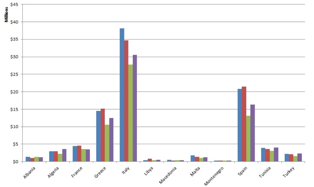
Based on historical observations the most affected country (with the greatest losses per year) is Italy (Pic. 22,24,25), where the reason is a mountainous peninsula surrounded by the Mediterranean basin. The specific location of the Italian country places him between two major centers of medicane development, mentioned in the previous section (Pic. 7). Moreover, Italy has a large economy and a long coastline (Bakkensen, 2017). The storms, which make direct landfall are the most damaging. Next to the risk map very important is also an estimation of the damages of Mediterranean hurricanes (Pic. 26). The direct impact of the medicanes applies to locations surrounding the point of landfall (Pic. 25). The most important things, as happened at the Mediterranean cyclone landfall are high tides, flash floods, wind flooding, and surge damages.
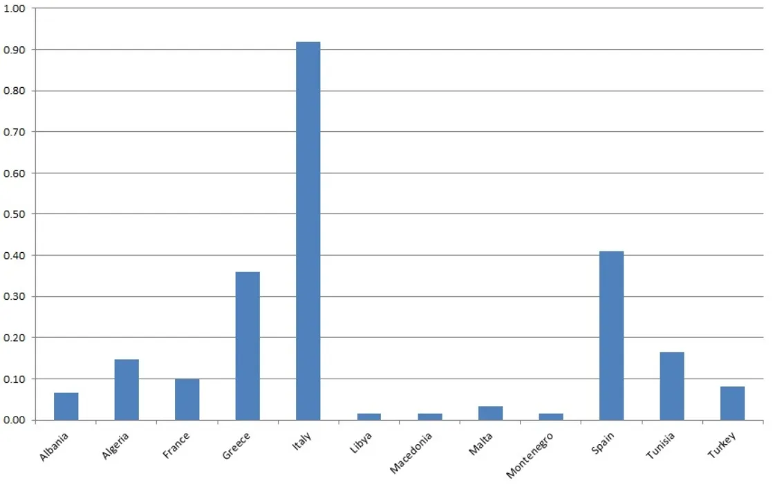
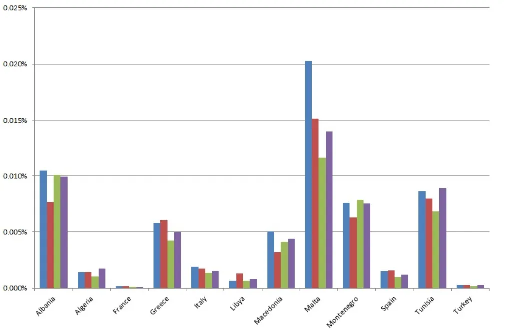
A country’s governments should be aware of annual expected damages caused by medicanes in terms of the Gross Domestic Product (GDP) value (Pic. 27). The studies have shown, that the small and less developed countries receive the most damage as a fraction of GDP (Bakkensen, 2017). The greatest fraction of GDP was lost in Malta, approximately 0.015% (Bakkensen, 2017). Highly developed European countries including France, Spain, and Italy are relatively less at risk for normalized losses due to their large economies (Bakkensen, 2017).
The important role of governments should be also the preparation of better disaster records and a standardized accounting scheme to characterize disaster records. Second, given the risk characterization, public policies on medicane warning and evacuation plans are important (Bakkensen, 2017). Some precautionary measures should be taken in order to effect the people’s evacuation and object protection. The policy decision must be made over short time frames. It is also important for governments to efficiently reduce the negative externality of secondary damages through building codes and zoning regulations (Bakkensen, 2017). Better historical data on medicane impacts gives better characteristics of current risk rates and expected damages from these storms. Thanks to this will be better to create the location and disaster-specific damage functions. People’s awareness about medicanes should exist also outside of the Mediterranean. Some hurricanes used to reach Macedonia. It is a likelihood, that due to global warming, the medicanes will reach also inland. For Mediterranean inhabitants important are optimal adaptation and risk management.
7. CONCLUSIONS

The Mediterranean tropical-like cyclones bring severe weather to all countries in the Mediterranean basin. The most affected country is Italy, because of the long coastline and peninsular location between two major regions, where medicane is produced. These regions are the Ionian Sea and the Balearic Isles area. The Mediterranean tropical-like cyclones occur rarely, however, due to global warming their frequency can increase. These hurricanes are the most dangerous weather phenomena observed in the Mediterranean region, which brings flash flood, gusty winds, a deluge of rain, high tides, and upsurge damages. It is reflected in local economies and Gross Domestic Product, especially in less developed countries. The most dangerous medicane landfalls occur on islands like Corse, Sardinia, Malta, and Balearic Isles. The Mediterranean tropical-like cyclones are not the only severe weather occurring in the Mediterranean region. They’re also known for a lot of deep cyclones and serious thunderstorms, which can happen in the same period of the year when medicanes can be observed. One of the examples of this kind of weather I experienced during my holiday time in Mallorca. I witnessed multiple thunderstorms, downpours, and flash floods, which interfered a normal day-to-day life and damaged crops. Despite a much smaller impact, than observed in medicanes people cannot ignore these weather situations due to their severity. The main period, when both medicanes and most of the serious thunderstorms are observed falls between September and January. This is the effect of much colder air mass intrusion into the warm Mediterranean Sea surface. Thanks to many studies carried out over the last decades we have a lot of information about medicane formation, which will be helpful for preparing some risk maps and damage estimation. The most important is the people’s awareness, which has to increase in order to protect their lives and tangible goods from the hurricane’s impact. There is still a lot of things to do both by scientist and local authorities. Hopefully, some relevant solutions will be implemented soon, because if not people won’t be prepared for this kind of weather. As it worsens due to global warming Mediterranean tropical-like cyclones will occur more often.
Mariusz Krukar
References:
- Bakkensen L.A., 2017, Mediterranean hurricanes and associated damage estimates, (in:) Journal of Extreme Events, vol. 4 no. 2
- Cavicchia L., von Storch H., Gualdi S., 2014, A long-term climatology of Medicanes, (in:) Climate Dynamics
- Frei C., Shar C., 2001, Detection probability of trends in rare events: Theory and application to heavy precipitation in the Alpine Region, (in:), American Meteorological Society,
- Jansa A., 2003, Miniciclons a la Mediterrania, (in:) IX Jornades de Meteorologia, Fontsere E., Barcelona
- Miglietta M.M., 2013, Analysis of tropical-like cyclones over the Mediterranean Sea through a combined modeling and satellite approach, (in:) Geophysical Research Letters, vol. 40, i. 10, p.2400-2405
- Nastos P.T., 2015, Mediterranean tropical-like cyclones: Impacts and composite daily means and anomalies of synoptic pattern, (in:) Atmospheric Research, vol. 208, p.156-166.
- Tous M., Romero R., 2011, Medicanes: cataloguing criteria and exploration of meteorological environment, (in:) Tethys – Journal of Mediterranean Meteorology & Climatology
- Tous M., Romero R., 2013, Meteorological environments associated with medicane devlopment, (in:) International Journal of Climatology, vol. 33, i. 1 p. 1-14
- Tous M., et. al., 2009, Mediterranean cyclones in a changing climate (in:), 11th Plinius Conference on Mediterranean Storms, Barcelona
Links:
- Mediterranean tropical-like cyclones: what are they?
- Blog.metoffice.gov.uk: Medicane bringing rough seas to Mediterranean
- Phys.org: What we know about medicanes?
- Fromthegrapevine.com: Do hurricanes happen in the Mediterranean?
- Project on Mediterranean hurricanes
- Last medicane – Zorbas 2018
- Zoning regulations
- 2016-12-16 Storm eastern Spain, December 2016 – forecast
- 2016-12-20 Deadly flood inundates south east Spain
- 2016-12-19 Majorca under water
- 2016-12-19 Serious flooding as more than a month’s worth of rain falls on Majorca
- 2016-12-21 Weather set to improved but flood risk being monitored
Wiki:
Youtube: