Why Indoor Mapping Is A Game Changer For Transportation Hubs

Indoor mapping transportation hubs

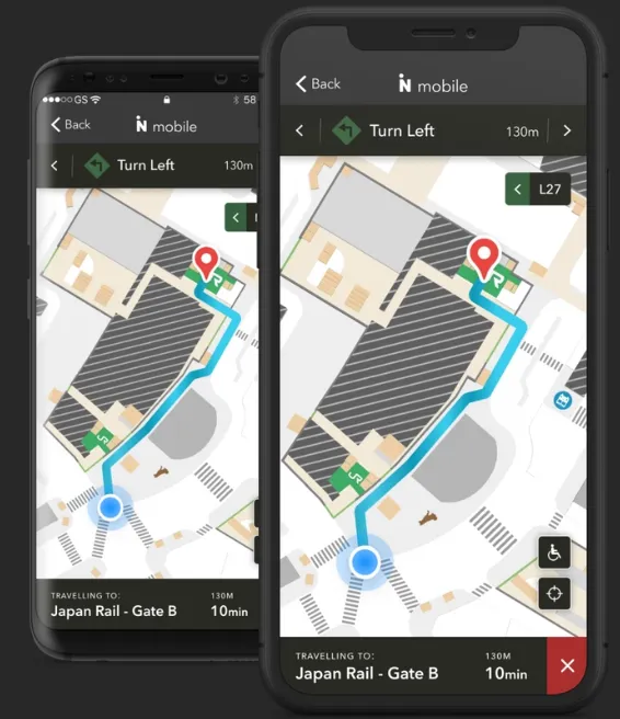
Imagine if you could know exactly where you were inside a building, without ever having to ask for help. Indoor mapping is making this a reality, and it’s changing the way we navigate transportation hubs like airports and train stations. With indoor mapping, passengers can easily find their way to their gate or platform, no … Read more

The quickest way of making the speed limit map

Speed limit map London OpenStreetMap

Previously I explained to you how to make the speed limit in QGIS and display it in Google Maps. This process required drawing the new layer including the speed limit of the given road sections collected from the Waze.com map service. Admittedly this is not the quickest way of getting a map such as this, … Read more

Creating your own speed limit map in QGIS and showing it interactively in Google Maps

Recently I showed you how to collect the speed limit data about the specified section of the road. It’s obviously a huge step toward the speed limit map preparation.  Reading the last article you got to know some examples of beautiful and very useful speed limit maps. In this reading, you will get knowledge about … Read more

How to make an isochrone map in Google MyMaps quickly?

Google Mymaps isochrone map

The Isochrone map shows how much time we need to travel between one location and another. This kind of map is very useful in geography, hydrology, transport and urban planning. In this article, I focus on transport planning only. There are a few major services, offering the isochrone map generations “for free” relatively quickly. Unfortunately, … Read more