Skip to content
Astro-Geo-GIS

An original point of view

  • Home
  • Blog
  • Projects
    • Gregorian calendar 1601-4000
      • Gregorian Calendar Calculator
    • Solar eclipses
      • European Eclipse Quadruplet
  • Shop
  • Liaison
    • QGIS tutorials
    • ArcGIS tutorials
  • Maps
  • Tours
  • Workshop
  • Books
  • Files
  • Gallery
  • Links
    • GIS links
  • Media
  • Contact

ArcGIS

The section is dedicated to various ArcGIS solutions, innovative implementations, and the relationship with a modern GIS environment.

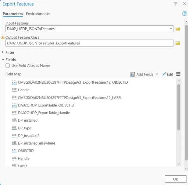
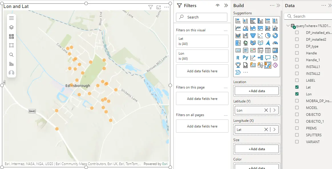
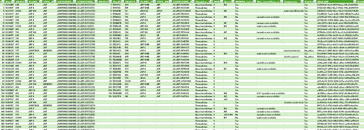
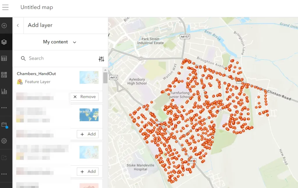
Automated email notification in ArcGIS Field Maps Designer

2025-02-26 by Krukarius
Integromat make with Field Maps Designer

Field Maps Designer is a mobile solution integrated with ArcGIS Online, which allows users to capture the data on-site. On top of that, Field Maps Designer enables users to create notes, perform some inspections, and, most importantly, share all the information instantly with the office. In this article, I would like to pay attention to … Read more

Categories GIS Tags ArcGIS, Automation, HTML Leave a comment

ArcGIS Pro – Changing field names by the export

2025-02-18 by Krukarius
ArcGIS Pro export features

Changing the field name should be easy in ArcGIS Pro. The link and video below show how to do it quickly. I propose an alternative method for exporting your layer to answer the situation presented in the forum thread below. See all the steps below: 1. Right-click on your layer -> Data -> Export Features … Read more

Categories GIS Tags ArcGIS Leave a comment

Fetching ArcGIS Online layer into Power BI

2025-02-04 by Krukarius

This text is somewhat the expansion of this tutorial, which explains how we can load the ArcGIS Online layer attribute table into Excel via PowerQuery. As PowerBI is considered here, these steps are the same, although there are things to look at before. 1. In the first step, we must equip our attribute table data … Read more

Categories GIS Tags ArcGIS, Power BI Leave a comment

ArcGIS Online attribute table to Excel – the most rapid export

2025-05-232025-01-16 by Krukarius
ArcGIS Online to Excel via PowerQuery header

Each layer uploaded or produced in ArcGIS Online has its attribute table. It’s the same as in other GIS tools like QGIS or ArcGIS Pro. If so, the user can export it to the spreadsheet and save it later as a .csv or .xslx file, for example. The classical exporting method is through the layer … Read more

Categories GIS Tags ArcGIS Leave a comment

Transfer AutoCAD drawing to ArcGIS Online part III

2025-05-282023-10-12 by Krukarius
Transfer layer from AutoCAD to AGOL via QGIS

The last bit of this whole text covers the full guidance for the creation of the individual feature hosted layer, which can be used next for all available ArcGIS Online tools. In the last article, you’ve learned how to prepare your AutoCAD layer upon its further loading as the file to ArcGIS Online. In fact, … Read more

Categories GIS Tags ArcGIS Leave a comment

Transfer AutoCAD drawing to ArcGIS Online part II

2025-05-282023-10-02 by Krukarius
Transfer layer from AutoCAD to AGOL via QGIS 2

The previous post explained to you the simplest way of migrating the AutoCAD drawing to ArcGIS Online. It included the important bits like the AutoCAD layer extraction as well as its further import to QGIS. In fact, this is the section, that doesn’t change, so if you are not familiar with it jump to the … Read more

Categories GIS Tags ArcGIS, AutoCAD, QGIS 1 Comment

Transfer AutoCAD drawing to ArcGIS Online – part I

2025-05-282023-06-08 by Krukarius
AutoCAD to AGOL via QGIS

This is the two-piece article, which aims to show you how to successfully add the AutoCAD LT drawing to the ArcGIS Online platform. In part 1 the superficial layer will be chosen, whereas the second bit will be more advanced. There is an instruction on how to load any GIS layer correctly to your ArcGIS … Read more

Categories GIS Tags ArcGIS, AutoCAD, QGIS 6 Comments

Translate into your language

Categories

Archeology Archival Astronomy Astrophotography Astrophysics Astrotourism Cartography Climate Data External Geodesy Geology Geotourism GIS Hydrology Infrastructure Innovations Long-distance observations Miscellaneous N/A Optics Paleontology Photography POLSKI Relief Spatial planning SPONSORED Tourism Transport Travel Video Weather Wildlife

Tags

Astrosoftware (9) Atmosphere (14) Atmospheric optics (14) AutoCAD (11) Clouds (9) DSLR (20) England (17) Flightseeing (8) Geocoding (8) Google Earth (26) Google Maps (15) Haze (10) HTML (7) Image processing (12) Interactive maps (21) JavaScript (12) Light (24) Lunar eclipse (9) Macro Photography (9) Mobile apps (12) Moon (10) Mountains (23) Night Photography (9) Nikon (14) OpenstreetMap (10) Panorama generator (7) Poland (24) Python (10) QGIS (30) Sky (16) Smartphone Photography (10) Solar eclipse (35) Solar System (17) Spain (11) Stargazing (19) Street View (10) Sun (10) Trip (17) Twilight (18) United Arab Emirates (7) United Kingdom (35) USA (17) VBA Excel (15) Webcam (12) XML (9)

Social wall

Tumbrl
Tik Tok
X widget
Pinterest
Instagram
Youtube
Facebook
Patreon logo
Buy me a coffee logo
© 2025 Astro-Geo-GIS • Built with GeneratePress