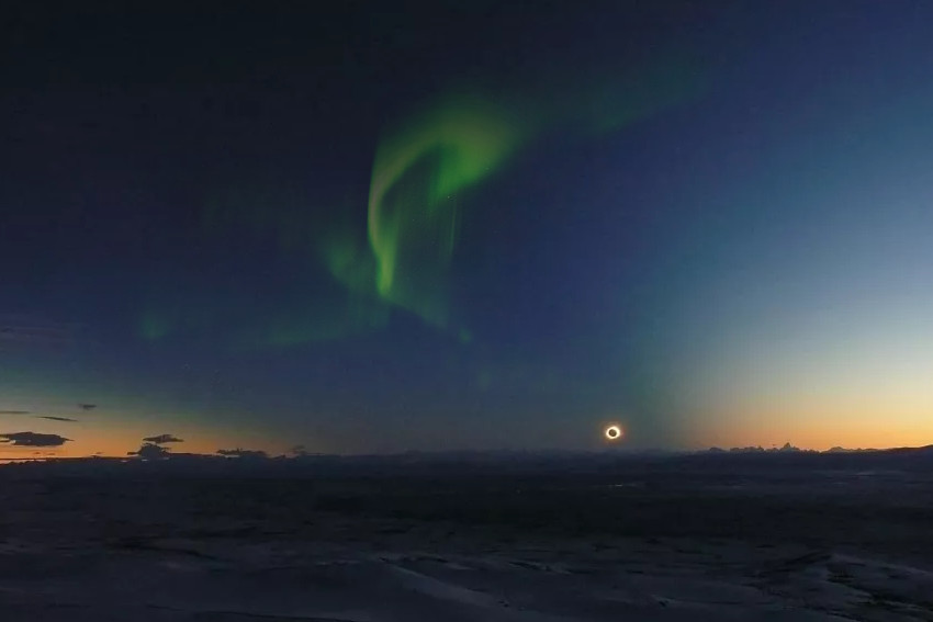
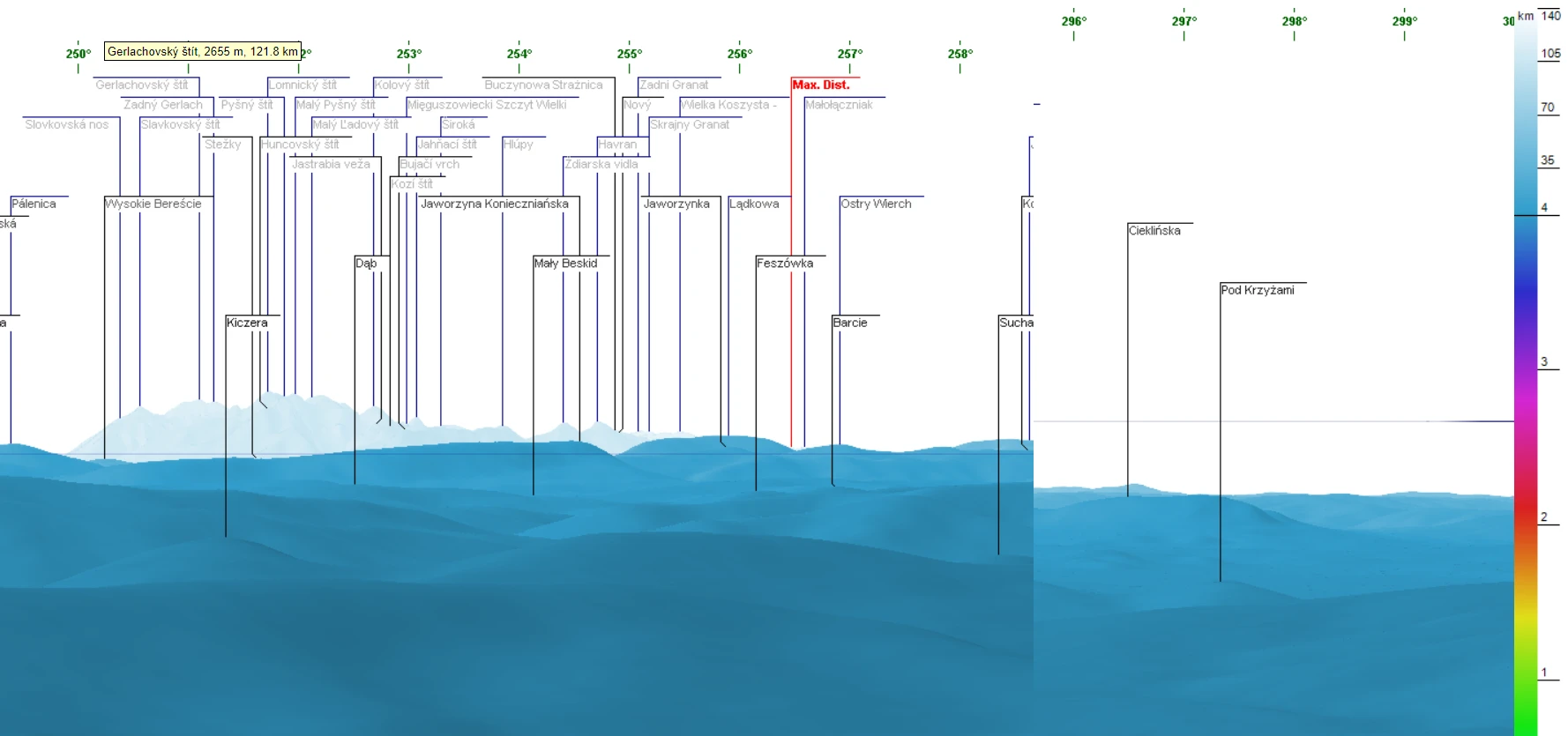
Top 100 the most beautiful places from where you could observe annular or total solar eclipses in the 2021-2040 period

Eclipses and tourist places Top 100 2021-2040

This article is probably a compression of the ebook, which I would like to release in the nearest future about the 500 spots, from where you could observe both annular and total solar eclipses worldwide in the 2021-2040 period. I have inspiration from the Sky and Telescope magazine, which has prepared recently a similar list … Read more

10 the most spectacular celestial events to watch in 2021-2040

Top 10 celestial events up to 2040

This text is somewhat the continuation of the previous one, tailored for the most unique celestial events or group of celestial events, which will occur in the 2021-2030 decade. This time you will read about 10 of the best occurrences in the sky within the next 20 years. Some of the astronomical events described in … Read more

Clever way of batch converting Latitude/Longitude to Ordnance Survey XY in Excel

Converting Lat/Lon to OSGB in Excel

The Ordnance Survey grid conversion is usually required when dealing with some projects across the UK. Usually, along with the standard WGS 84 datum, we need to define X (Easting) and Y (Northing) coordinates. This task might be quite time-consuming when converting our locations one by one. Fortunately, we have some tools, which can do … Read more

The most unique astronomical events you shouldn’t miss in the 2021-2030 decade

Moon Venus Mars and Milky Way 2029

Recently we have entered the new decade 2021-2030. This is a good time to take a look at what major astronomical events will occur throughout this time. I don’t mean typical celestial events, as known from a vast majority of astronomical calendars issued usually on a yearly basis. I would like to take a deep … Read more

Several important reasons why you should see the 2026 solar eclipse

Total solar eclipse 2026 and aurora

It’s still quite a lot of time to the 2026 total solar eclipse event, which has been already considered by me in terms of the possibility of seeing its impact on the atmosphere when the phenomenon happens below the horizon.  However, the character of this path of totality requires attention far earlier than normal, as … Read more

5 fantastic tips & tricks for the Ulrich Deuschle panorama generator

Udeuschle blueness of the horizon

If you are interested in long-distance observations or simply panoramic views from some location, mainly mountain peaks or hills, you should have heard about the Ulrich Deuschle panorama generator. This is the web-based tool, which in 2010 successfully superseded its predecessor – Kashmir 3D software, which was based on simple digital elevation model (DEM) files … Read more

How to capture any interactive map larger than screen easily?

Capturing the map larger than screen

There are a few nice tools, which help you to get your map larger than the screen of your desktop. However, all of them are predominantly focused on Google Maps, which is the most popular interactive map platform. If you want to have your Google Map bigger than your screen, even up to 12000x12000Px resolution … Read more

How to display your KML file on Google Earth with the map tile layer?

OpenStreetMap in Google Earth Sierra Nevada

Google Earth is a handy tool, which includes much information. Most of this information can be shown as the layer overlaid on the satellite imagery covering our virtual globe. These layers can be displayed along with our own .kml files plotted into our area. The layers built into Google Earth are not sole. The user … Read more

Bulk text field name changes in multitude of KML files without programming knowledge

Bulk text name changes in KML files

In this thread, I would like to describe a swift method, which allowed us to make some changes within the .kml files. I am focusing on the names of columns inherited from the .shp files, although the described method can be applied to other texts and even some values too.  What is most important, we … Read more

PicPick – the best screen capture application for Windows

PicPick effects

This article is aimed at the recommendation and substantial guideline for apparently the best screenshot application available on the market, which is the PicPick application. Probably you have been wondering how can I create arrows or some weird elements in my screenshots from time to time. All of them have a common source – the … Read more

The Astropixels.com ephemeris data extractor

Astropixels.com ephemeris data extractor

I would like to introduce the new tool, whose goal is to extract the ephemeris data from the Astropixels.com service.  Before I start to describe the major features of my program I would express a big thanks to Fred Espenak the author of this platform. Fred Espenak is already a retired American astrophysicist, whom we … Read more

Good way to sanitizing a bulk address list, part 1 – Excel & VBA

Sanitizing addresses in Excel

When you work with any Excel data, probably you experienced sometimes, that the spreadsheet input looks messy.  I personally deal with the address data predominantly, which you could notice by reading my previous articles about geocoding and reverse geocoding.  What is the most fun here, even the reverse geocoding results can bring confusion to our … Read more

Total solar eclipse 2020 – remote chasing the umbra and a brief explanation how do the webcams work

Total solar eclipse below the horizon Namibia 2020

The total solar eclipse on December 14, 2020, was the last one in the 2nd decade and obviously the first “Twenty Years Solar Eclipse Path Tables”  of the XXI century. Most people call this eclipse the COVID eclipse, due to omnipresent travel restrictions, which kept a lot of eclipse chasers in their homes. They could … Read more

QGIS2web legend & scale and other elements in OpenLayers map library

QGIS legend and scale edits

Legend and scale besides the pop-up window and labeling is another important map element, which everyone wants to have clean and tidy. In this shorter (I hope) article I want to explain to you how to customize the legend for your OpenLayers map generated by the QGIS2web plugin and add some relevant elements like a … Read more

Fireworks around the world! Happy New Year 2021 to everyone!

Geneva fireworks Deckchair

Another year is coming now. The year will open the 3rd decade of the XXIth century. Time flies. It looks like it’s already 5th time when I am wishing you a Happy New Year! As usual, I would like to share with you the memories from this special night, which is already around the corner … Read more

Reverse geocoding in Excel without loosing money

Reverse geocoding in Excel

The previous 3 articles concentrated on the geocoding process in Excel for free. I considered the Google Sheets option and also the VBA Excel tools applicable to Bing, Nominatim, and others. Now it’s the best time to explain the process from another way around. Sometimes we have a situation when reverse geocoding is more needed … Read more