UK Address sanitizer in Excel 365

UK Address sanitizer tool

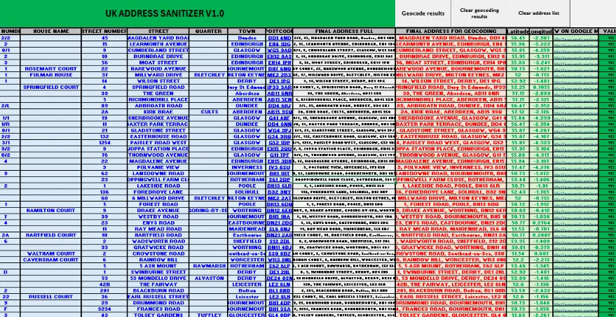
This article will shortly describe the tool I needed to develop recently. It is aimed at addressing cleansing. The general lists of addresses are often messy. It means, that the components of the address aren’t ordered well amidst various spaces and commas in the wrong places. It eventually excludes these addresses from proper geocoding and … Read more

Quick transfer the QGIS legend from print layout to Excel

Transfer legend from QGIS to Excel

Maybe you were wondering about the possibility of transferring the legend from the QGIS print layout to Excel? This short text shows you how to do it, especially for the simple legend, which won’t last long. The tutorial is oriented toward not programming-savvy people, therefore please don’t expect any kind of automatization here. Of course, … Read more

Opening Google Street View in VBA Excel

Open Street View from Excel

Opening websites programmatically at their certain addresses is quite a straightforward thing regardless of the programming language. Previously I dealt with launching Google Maps from the Excel document with the Google Chrome browser.  Now I would like to explain to you briefly the option, which allows you to open the Street View image anywhere you … Read more

Clever way of batch converting Latitude/Longitude to Ordnance Survey XY in Excel

Converting Lat/Lon to OSGB in Excel

The Ordnance Survey grid conversion is usually required when dealing with some projects across the UK. Usually, along with the standard WGS 84 datum, we need to define X (Easting) and Y (Northing) coordinates. This task might be quite time-consuming when converting our locations one by one. Fortunately, we have some tools, which can do … Read more

The Astropixels.com ephemeris data extractor

Astropixels.com ephemeris data extractor

I would like to introduce the new tool, whose goal is to extract the ephemeris data from the Astropixels.com service.  Before I start to describe the major features of my program I would express a big thanks to Fred Espenak the author of this platform. Fred Espenak is already a retired American astrophysicist, whom we … Read more

Good way to sanitizing a bulk address list, part 1 – Excel & VBA

Sanitizing addresses in Excel

When you work with any Excel data, probably you experienced sometimes, that the spreadsheet input looks messy.  I personally deal with the address data predominantly, which you could notice by reading my previous articles about geocoding and reverse geocoding.  What is the most fun here, even the reverse geocoding results can bring confusion to our … Read more

Reverse geocoding in Excel without loosing money

Reverse geocoding in Excel

The previous 3 articles concentrated on the geocoding process in Excel for free. I considered the Google Sheets option and also the VBA Excel tools applicable to Bing, Nominatim, and others. Now it’s the best time to explain the process from another way around. Sometimes we have a situation when reverse geocoding is more needed … Read more

The costless way to geocoding addresses in Excel – part 3, bulk data geocoding with Nominatim and other geocoding tools

Nominatim address geocodinmg Excel

The 3rd part of this vast article about geocoding is slated for discussion about another free geocoding tool for MS Excel, namely the OpenStreetMap Nominatim geocoding and other remaining tools, which could be worth attention. NOMINATIM GEOCODING TOOL The usage of this small tool is very simple, even simpler than Bing Maps API geocoding, however, … Read more

The costless way to geocoding addresses in Excel – part 2, via Bing Maps API

Bing geocoding addresses in excel

It’s been a while since the previous part of this article when I showed you the way of geocoding the addresses via Google Sheets.  Here you will get the knowledge of geocoding straight from the Excel sheet, without launching external platforms. A front of your eyes you have another two options. These ways were mentioned … Read more

How to show the coordinate grids in Google Earth and Google Maps?

Google Maps MGRS

There are a few ways to show the coordinate grids on Google Earth. The easiest way to show the coordinate grids in Google Earth is to select “Grids” from the “Tools” options. Then you will have full zoomable coordinates grid cover (Pic 1 – 3). The default coordinate system bound to Google Earth is the … Read more