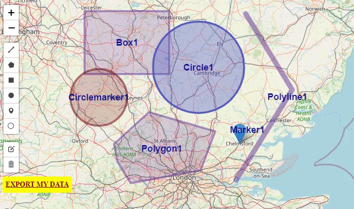
Folium Draw plugin – extended functionality

Folium draw plugin

The Draw is a very nice plugin dedicated to anyone who wishes to draw editable vectors on the Folium map. It’s a comprehensive plugin, that can add lines, polylines, polygons, rectangles, circles, circlemarkers, and markers and then edit or delete them. Its functionality is the same as in the Leaflet Draw plugin, where its Folium … Read more

Quick access to Street View from various applications (based on Leaflet map example)

Street View access from various maps

Everyone knows how Google Street View is needed for the desktop investigation of various issues. It’s very beneficial since we have access to this Google product from another platform, certainly dedicated to some topic. Indeed, there are quite a few ways of getting the Street View visible at the same time when browsing the specified … Read more

Opening Street View with Python Folium map

Street View with Python folium map

Folium is a powerful Python library dedicated to geospatial data visualization. Its major engine is based on Leaflet – an open-source JavaScript library for mobile-friendly interactive maps. There are a lot of sources on the web, where anyone can find the basics of data displaying with Python Folium in several different ways. Most of them … Read more

Original Street View colors without Google API Key

Street View colour inversion

Street View is a good tool, which can be incorporated into your own interactive maps like Leaflet or OpenLayers. Unfortunately, since 2018 Google hasn’t served it for free. In turn, the Google Maps products can’t be set up properly, because you can see the “For development purposes only” information along with the poor quality of … Read more

Saving Openlayers custom drawings as the .geoJSON file

OpenLayers custom drawings

In this short post, I would like to demonstrate to you the programmatic method of saving the custom shapes in OpenLayers as the .geoJSON file. Drawing your own features on the OpenLayers map canvas equipped with some existing layers, like it takes place in the case of the map rendered by the QGIS2Web plugin can … Read more

QGIS2web legend & scale and other elements in OpenLayers map library

QGIS legend and scale edits

Legend and scale besides the pop-up window and labeling is another important map element, which everyone wants to have clean and tidy. In this shorter (I hope) article I want to explain to you how to customize the legend for your OpenLayers map generated by the QGIS2web plugin and add some relevant elements like a … Read more

Upload vector layers to Windy.com in order to check the weather for your trip

KML layer at Windy.com

It’s been about half a year since Windy.com launched an option to upload .kml, .gpx and .geojson files into the weather map. It happened thanks to the Leaflet-kml plugin, available here. Apart from the Leaflet Javascript API map software, where we can use this plugin for loading our own .kml files, we can add them … Read more

Excel Spreadsheet batch data geocoding for GeoJSON and JSON files

GeoJSON output in Leaflet

Recently I was dealing with geotagging single addresses in Google Maps and other easily accessible tools. However, the stuff, that I focused on is playing around with single placemarks only. I believe, that this operation is much more useful when we take into account not only the address but other details, related to this place. … Read more

How to make an isochrone map in Google MyMaps quickly?

Google Mymaps isochrone map

The Isochrone map shows how much time we need to travel between one location and another. This kind of map is very useful in geography, hydrology, transport and urban planning. In this article, I focus on transport planning only. There are a few major services, offering the isochrone map generations “for free” relatively quickly. Unfortunately, … Read more

Input multiple address list to Google Maps and Google Earth – the quickest way

Excel address list in Google MyMaps

Google Maps, as well as Google Earth, are very useful tools in terms of location finding. A user can find a proper address quickly in any place in the World. Sometimes we are obligated to find multiple locations for different purposes. Then it can be a problem for someone, who must have a multitude of … Read more

Total solar eclipse vizualisation on Google Earth, part 2

Solar eclipse visualization Google Earth

<<< Read the 1st part of The solar eclipse visualization on Google Earth In the 1st part of this article, I showed you how to create the “umbra” in Scribble Maps and use it in Google Earth as a .kml file. Here I would like to demonstrate step by step how to create a pretty … Read more