
Astrophotography with the Peakfinder.org, part 2 – solar & lunar eclipses
In the 2nd part of this short guide on the Peakfinder.org panorama generator, I would like to focus on another kind of observation, that we can enjoy. There are solar & lunar eclipses. Those celestial events are quite rare (especially solar eclipses) so this is the prime reason, that we should prepare as best as possible.
Previously I have explained how to use the Peakfinder.org panorama generator in conjunction with the solar and lunar ephemeris. I have found, that this website can be helpful for planning solar & lunar eclipse observations. Despite no proper signatures (the Sun in Peakfinder always looks the same, Moon changes due to phases) this matter is possible when using appropriate websites for it.
To say, apart from Peakfinder.org you need to open:
– NASA Eclipse home page – where you find detailed solar & lunar circumstances,
– Mooncalc.org – with rough Moon ephemeris for your location.
– Xjubier free.fr – with the most detailed interactive lunar eclipse maps.
I would like to show the solar eclipse issues first, because (at least) for me it is easier to demonstrate it. The aforementioned NASA Eclipse home page provides detailed Google Maps-based circumstances for almost all solar eclipses between 2000 BC and 3000AD. I will focus on a few forthcoming eclipses. It’s good to mention, that this website can be useful for staggering your photos not only for total or annular eclipses but for partial ones too.
When you browse the Nasa eclipse web page you have a few choices of the eclipse databases (Pic. 1).
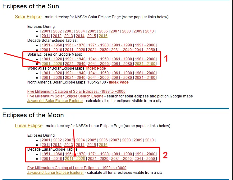
Pic. 1 The NASA Eclipse web page with the solar and lunar eclipses database: 1 – selecting solar eclipses for the 2001-2020 period, 2 – selecting lunar eclipses for the 2011-2020 decade.
All databases have been divided into decades, from which you can choose a single solar eclipse. It is advisable to click on the link to Google Maps rather than Global Map (Pic.2) because it will be easier for you to get around.

Pic. 2 The NASA eclipse database for the 2011-2020 decade with the “Link to Google Map” row highlighted and the first forthcoming total solar eclipse from now.
In this section, you can find the total and annular solar eclipses only. Basically, there is no Google map provided for partial eclipses, however, bear in mind, that either total or annular solar eclipse occurs as a partial one on a wide area.
When you are in, click “Large map” and find the observation site taken into consideration and put a marker there (Pic. 3,4). I will not explain this profoundly now. If you want to know more read my previous articles about the visualization of the total solar eclipse on Google Earth.
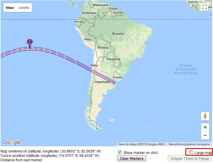
Pic. 3 The total solar eclipse path shown on Google Maps. Click “Large map” on the right bottom corner to make it much bigger.

Pic. 4 Then find your observation site and put the marker. In my case, this is Bella Vista in Argentina.
When you have got your location ready open the Peakfinder.org website and find the same location there (Pic. 5) using the “Maps” option. Sometimes your location may be used repeatedly and the outcome found in far different places (like Cambridge UK, Cambridge US or York UK, Youk WA, etc.). When you have issues like this put another (bigger) town into the bracket and check which one matches up (Pic.5).

Pic. 5 Finding your location on Peakfinder.org website: 1 – Name of the location (town/city) in the bracket, 2 – Search option, 3 – The most suitable location found, 4 – Our location, that the same name appears in Spain.
Once you find your location click “Goto” in Peakfinder and enjoy your view! (Pic. 6). Remember, that you have to adjust your local time to the one given by the Nasa webpage (GMT 0). For this place (Argentina) it will be GMT-3).

Pic. 6 The Sun’s position at moment the totality near Bella Vista in Argentina on 2nd July 2019.
For this location, the Sun seems to be too high to snap it beyond mountains. You can find then a better place (Pic 7,8), located not far from your initial location.


Pic. 7,8 Another potential observation site (near Arrequintin church) on road no150 headed Chile border.
The next solar eclipse is an annular one. The path starts in eastern Saudi Arabia and proceeds toward the southeast via Qatar, United Arab Emirates, and Oman. There are a lot of places, where you can take pictures of a deep partial eclipse with Al Hajar mountains, which fall tens of kilometers from the path of annularity. The obscuration during the maximum eclipse will reach nearly 90%. I found one place in the eastern United Arab Emirates (border city Al Ain) with an amazing view of this eclipse just after sunrise (Pic. 9,10).


Pic. 9,10 The partial solar eclipse after sunrise above Al Ain in the United Arab Emirates near the Oman border. The greatest eclipse will occur around 30 minutes after sunrise above Jebel Hafeet on 26th December 2019.
There are already many examples of solar eclipses chased above the beautiful mountainous horizon. See a few below:

Pic. 11 The total solar eclipse on 11th July 2010 captured above Andes (El Calafate) just before sunset, Janne Pyykkö, apod.com.

Pic. 12 The total solar eclipse on 20th March 2015 seen from Svalbard, Frank Tomaras, rascmontreal.org

Pic. 13 Partial solar eclipses on 26th January 2009 seen over Manila Bay in Binondo, Alberto Lao, spaceweathergallery.com
Pic. 14 Partial solar eclipses during sunrise above Sucha Góra range on 31st May 2003 seen from Zręcin, Wacław Moskal, ptma.krosno.pl
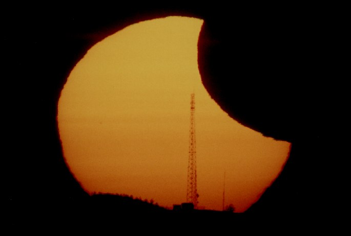
Pic. 15 Partial eclipsed Sun rising above the Dział hill telecom transmitter in Dynowskie Foothills, Mariusz Świętnicki, ptma.krosno.pl

Pic. 16 The annular solar eclipse on 20th May 2012 just about sunset seen from Roosevelt in New Mexico, Kevin Baird, flickr.com
In the case of the lunar eclipse, this exercise is not as straightforward as could be, as long as you decide to use the Nasa Eclipse website for it. The Nasa Eclipse Web Site doesn’t supply the lunar eclipse data with Google Maps. Only general patterns in .pdf format are available. Once you open the calendar date of the lunar eclipse link you should have all general information as per below (Pic.17), with the scant eclipse graph on the bottom (Pic. 18). You need to zoom it in as much as possible to figure out the eclipse phase in your location.


Pic. 17,18 The lunar eclipse of 31st January 2018 pattern provided by Nasa Eclipse Web Page: 17 – general view, 18 – Eclipse graph with the red arrow, that shows the area of consideration (north-east Poland).
The red arrow on the pic. 18 shows my observation site in the extreme northeast part of Poland. Only there end of the partial phase will be visible. I would like to check how my observation site will look during this moment. Having this poor graph only I can’t really find my place on Peakfinder.org. Much helpful will be both Mooncalc.org (Pic. 21,22) and new lunar eclipse interactive maps provided by Xavier Jubier (Pic. 19, 20), which you can use along with Mooncalc.org to figure out where exactly the eclipsed moonrise or moonset is going to happen.


Pic. 19, 20 January 31, 2018, total lunar eclipse circumstances for eastern Europe and northeast Poland, where moonrise will occur just before P4 contact.

Pic. 21 The Mooncalc.org interface with considered observation site in Dworczysko near Sejny: 1 – Location bracket (Nearest town), 2 – Time (top bar to scroll reft-right, yellow – Moon above the horizon, blue – Moon below the horizon), 3 – Moonrise azimuth, 4 – Current Moon position, 5 – Moon track across the sky, 6 – Moonset azimuth, 7 – Current local circumstances, 8 – Terminator line, 9 – Civil dusk line.

Pic. 22 Close-up views of the observation site (marked number 1). On the top, you should have a lunar eclipse toolbar available on an intermittent basis. Clicking “more” (marked number 2) you will have general information about previous and forthcoming lunar eclipses possible to see from this location. Unfortunately not useful for our purpose.
When you have prepared the observation site in the Mooncalc.org server go to Peakfinder.org and find your location there. Once you do this you can check the best place for lunar eclipse observation. On 31st January 2018, the partial eclipse ends at 16:11 GMT+1. It’s going to be really hard to see the last minutes of this partiality from there (Pic. 23,24).
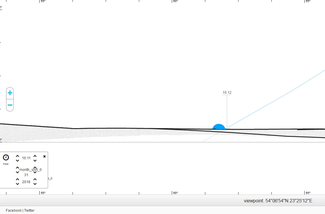
Pic. 23 Moonrise above Dworczysko village near Sztabinki lake, 31.01.2018, 16:11.
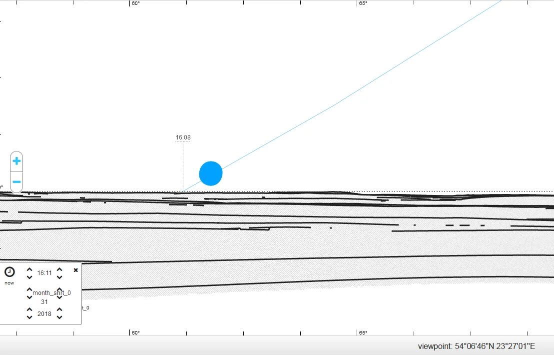
Pic. 24 Moonrise from the hill near Weresowszczyzna, 5km ahead from the last position, 31.01.2018, 16:11.
Maybe this example is not easy to demonstrate, so let’s take a look at the next lunar eclipse, which will occur in late July 2018 (Pic. 25, 26). Now I took into account 3 different locations, from where moonrise above mountains is possible on eclipse day (27.07.2018).

Pic. 25 Total lunar eclipse on 27.07.2018 circumstances with 3 various locations: 1: Chyzne (Poland), Oex/Sallanches (France), and the Gulvan peak near Fort William (Scotland).

Pic. 26 The same locations are shown on a more detailed, lunar eclipse interactive map provided by Xavier Jubier.
The first one refers to the beautiful mountainous corners of Lesser Poland. One of them is the Chyzne, a border village with Slovakia, from where a partially eclipsed Moon will rise above the Tatra Mountains (Pic. 27). It can be seen from Slovakian Orawa also (Trstena, Trvdosin).

Pic. 27 Moonrise above Tatras seen from Chyzne (Poland) on 27th July 2018.
The Chamonix region attracts tourists year by year. There are a lot of facilities, picturesque views and also the greatest opportunity to see the highest peak in Europe – Mount Blanc from a very short distance. It can be a perfect spot for lunar eclipse watchers on the 27th of July this year. You just need to go to Sallanches and set your equipment just a little bit north of the village to see the rising eclipsed Moon above Mount Blanc (Pic. 28).
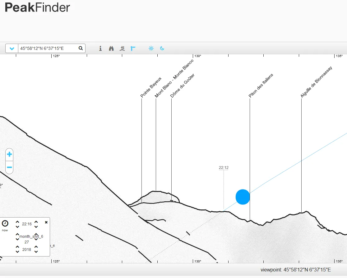
Pic. 28 Partially eclipsed Moon will rise above the Mont Blanc massif on 27th July 2018.
A totally eclipsed Moon will rise in Great Britain. Scottish people will have a great opportunity to see this occurrence right above their highest mountain – Ben Nevis. They only need to flock near Fort William alongside Loch Eil. There a brown Moon should rise around 22:10 at the very end of totality. For those, who want to see the total phase much longer is advisable to reach the Gulvain peak, which rises above the earlier mentioned Loch Eil (Pic. 29).
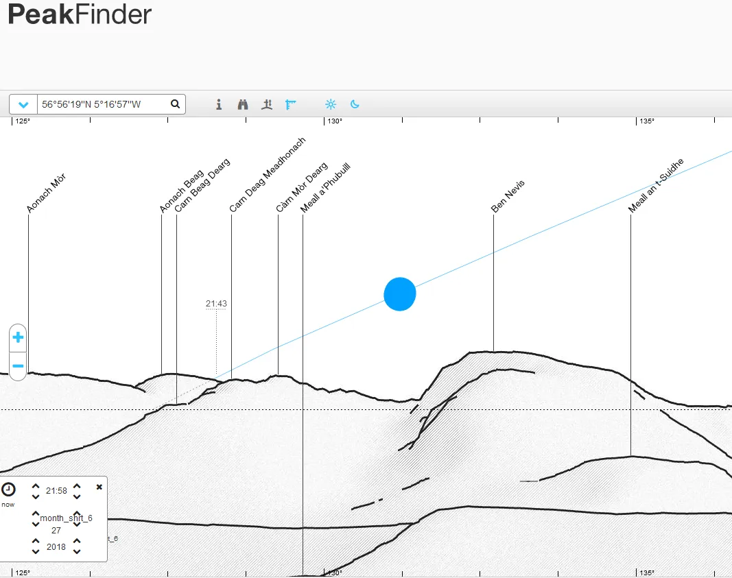
Pic. 29 The total lunar eclipse on 27th July 2018 with moonrise above Ben Nevis community seen from the Gulvain peak located on the opposite side of the River Lochy valley.
Despite the lack of appropriate signage (solar & lunar eclipse) on Peakfinder.org, at least for the time being I hope, that it will help you to plan roughly your observation site. There are simply website tools and I am pretty sure, that everyone should combat it. At the finish, I would like to show a few examples, that I found on the web. Unfortunately, I haven’t had an occasion to carry out this kind of observation yet.

Pic. 30 The moonset behind the Minarets (California) in the final phase of the total lunar eclipse on 8th October 2014, Jeff Sulivan, flickr.com.

Pic. 31 The mostly eclipsed Moon sets above the Indian Peaks (Colorado) on 10th December 2011, Pat Galnes, flickr.com.

Pic. 32 Partially eclipsed moon setting over Absaroka Mountains (Wyoming) on 4th June 2012, Mack Frost, flickr.com.
Mariusz Krukar
Links:
1. Peakfinder.org
2. Eclipse.gsfc.nasa.gov
3. Mooncalc.org
4. Xavier Jubier lunar eclipse page
Read also:
1. Total solar eclipse visualization in Google Earth