
- GENERAL INFORMATION ABOUT THE WOŁOSATE – ŁUBNIA BCP
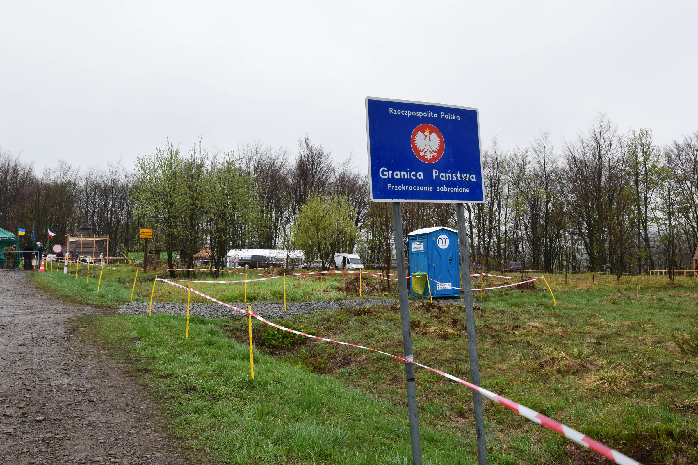
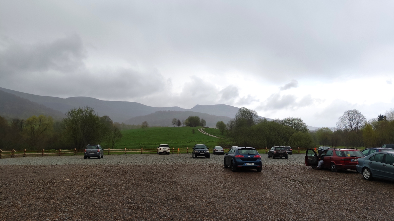
Wołosate is a small, and the southernmost village in Poland, which sticks to the Poland – Ukraine border in Bieszczady Mts. The only road, which leads across the village from Ustrzyki Górne is regional road no 897 with a 111km total length from Tylawa to the Poland-Ukraine border. Basically, this road terminates in the Wołosate main car park (Pic. 2), located near the Bieszczady National Park information point. A further section of this road is used by the red tourist trail (the Main Beskid Trail, leading to the Bukowska Pass), down to the small junction next to the bridge. Next, the very last part of this road leads through the bridge on Wołosatka stream towards the Beskid Pass (Przeł. Beskid), which is a border pass between Poland and Ukraine (Pic. 1). Normally no one is allowed to go there, because of both Bieszczady National Park and border zone restrictions.

There are vibrant discussions, which have been undertaken at least a dozen or so years ago about resuming this border crossing. However, a major problem lies in the wild environment of the UNESCO East Carpathian Biosphere Reserve, which could deteriorate due to high tourist traffic in this area. As far as I remember, the first serious discussion about it was in 2007, when a few new border crossing points were considered in terms of EURO 2012 Poland & Ukraine football tournaments. That time, the council of the Bieszczady National Park clearly stated, that there is no point to run the Wołosate – Lubnya border crossing for EURO 2012 purposes because fans won’t use it to get to the match.
Anyway, the main disagreement arose out of the protection of the East Carpathian Biosphere Reserve, especially a rare species listed in both national and world Red List of Threatened Species, i.e. few-flowered sedge.
As time flies the problem wasn’t solved due to a dispute between Ukrainian boards and Polish naturalists and ecologic organizations. Ukrainians living in Zakarpattia used to complain about the lack of any border crossing with Poland, whilst they have another 18 cross boundaries with Romania, Hungary, and Slovakia. On top of that, there were not enough funds for this purpose from the Polish government. As a consequence, the Poland-Ukraine border couldn’t be adapted to European standards.
The discussions about building a new border crossing point revived in 2015 when the Uzhanian National Park Council was holding a session between the management of three national parks composed of the East Carpathian Biosphere Reserve. Unfortunately, the problem has not been solved, due to the Polish side. The management of Bieszczady National Park was afraid of massive tourist traffic affecting the local precious environment again.
After another 2 years, the topic was alive again. At the 2017 Krynica Economic Forum, four new Polish-Ukraine border crossings, including Wołosate – Łubnia were announced. A major goal of this investment was to streamline the traffic between Poland and Ukraine, because of the extremely long waiting period. The plans for running all these boundary crossings were set in 2018. However, the Wołosate – Lubnya proposal was rather unlikely, as a result of poor road connections and a highly protected environment area.
For this whole several-year period a lot of tourists wanted to reach the Ukrainian mountains this way on foot.
The pivot point is, that the Wołosate – Łubnia border crossing has a huge social-economic meaning because of the relationship and tourist traffic development between the Subcarpathian and Zakarpattia regions. Today, if someone wants to get to the Ukrainian part of Bieszczady from Poland, have to go out of the way for about 120km, crossing the nearest border checkpoint in Krościenko, or even in Medyka when want to do it on foot or by bicycle. Moreover, you must take into account the estimated waiting times at the border. Opening a new border crossing between Wołosate and Łubnia would lead to marking a new, very interesting tourist trail. The general idea is to make this crossing point seasonal, only during the day, like the functioning tourist BCPs on the former Polish-Slovak border (Mrozek, 2016). The newly created border crossing point between Wołosate and Łubnia, in cooperation with another one, located on the Slovak-Ukrainian border would create a perfect hiking trail connecting all national parks included in East Carpathian Biosphere Reserve.
Recently there were a couple of historical initiatives, when on the Beskid Pass [Przeł. Beskid] a temporary border crossing point was running. The first moment, when tourists could get to Lubnya village from Wołosate occurred on September 14-15th 2018 under the Carpathian Days of Friendly Neighbourhood (Karpackie Dni Dobrosąsiedztwa). This initiative gave real hope for creating a touristic border crossing point between Wołosate and Łubnia.
Another time, when the temporary border crossing point at the Beskid Pass (Przeł. Beskid) was launched was during the Polish Early May Long Weekend for 5 days, between 1-5 May 2019. It was the time of the biggest traffic reported after the post-war history of this place. There were 2784 border crossings in total (1397 into Ukraine and 1387 into Poland). Mostly Polish people took advantage of this crossing point. According to the border guard, more than 950 Poles cross this border, whereas in the meantime about twice less Ukrainians. The border crossing point was opened between 9 a.m. and 6 p.m. according to GMT+2 time zone.
For now, we should hope, that the time, when this border crossing point will be launched is approaching.
2. OUR DAY TRIP
After this pretty long introduction, I would like to start by describing our one-day trip. In the meantime, I am going to develop some important information, regarding a particular section of our route and also point an another proposed trail, as can be made within a day period from Wołosate.
Well, we came to Wołosate about 9:20 am (Pic. 2). I wish we could have been a bit earlier, although the weather pattern wasn’t good enough to wake up so early. Unlike Krosno, where the sky was looking pretty good, as we were closer to Bieszczady, the cloudiness was increasing. More or less from Wetlina, it started drizzling and behind Ustrzyki Górne we caught the rain.

The first thing, that came to my mind – is the 1st of May, the 1st day when the Wołosate – Łubnia border crossing point is opened, then we should expect some crowds. Some tourists may go to the mountains for a few days. These concerns arose, when I saw a lot of people occupying the ticket box, where the Main Beskid Trail splits with a blue trail, ascending on the Pass under Tarnica [Przeł. pod Tarnicą] (Pic. 3).

Fortunately, the majority of these people were headed towards Tarnica, unlike the Main Beskid Trail, which was almost empty.
Wołosate nowadays is a small, although modern settlement, that offers accommodation for tourists. It’s worth knowing, that a while ago it was a relatively big village. Wołosate was first mentioned in the XVI century, however, since the beginning, this settlement has had a bumpy ride. In the XVII century, it was burned twice by local Carpathian brigands, called Touhay (Tołhaj), who used to rob merchant’s caravans, villages, manors, and also churches. The next century wasn’t better. In 1711 the village was raided by Swedish troops led by Magnus Stenbock. Afterward, the settlement was attacked from the south, by Hussars.
The biggest population of this village was reported around I World War – about 1200 inhabitants, most of them were Poles, however, Wołosate was a Boyko village at that time. There were about 200 houses and a nice Eastern Orthodox Church of Saint Demetrios. A whole village with the church has been erased from the map at Operation Vistula in 1947, whilst all people have been uprooted. A plain mark after the church is underpinning with the surrounding cemetery, which can be reached straight from the road (Pic. 4). This is one of the most important sites in this settlement, commencing a historical trail towards Tarnica.

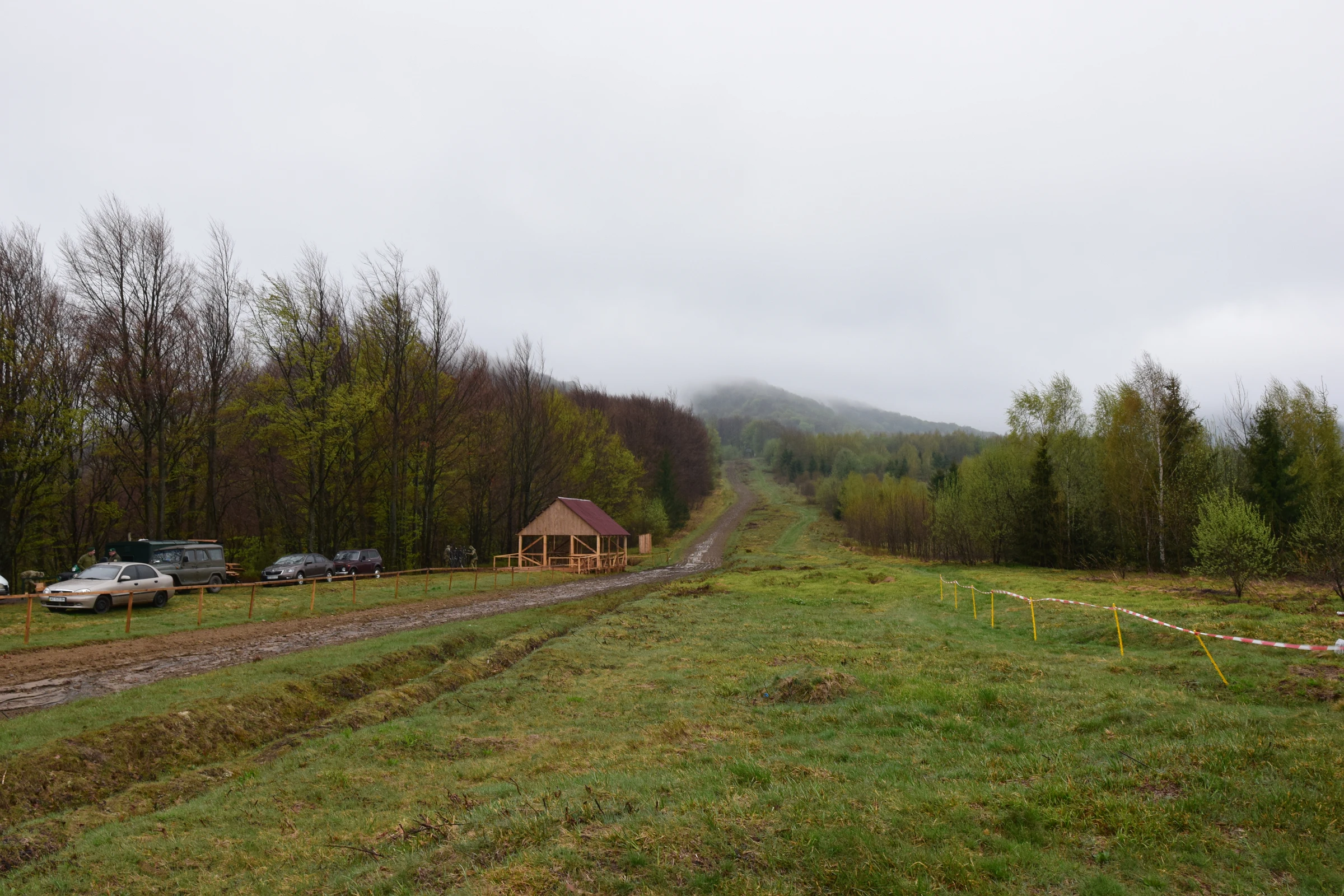
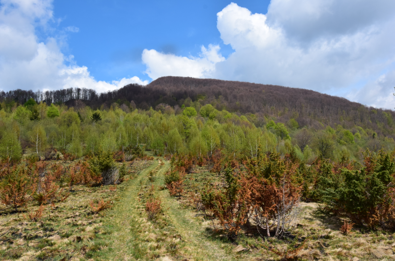
Wołosate lies in the shallow valley of the Wołosatka stream, which starts vis-a-vis a Menczył peak. Next, we are going upstream until we reach the junction. This is the moment when we must turn right on the Poland-Ukraine border. From now on, everything was new for me, because as I mentioned earlier, I couldn’t go there beyond this period. At first, we saw a few border guard cars, located alongside this narrow gravel road, just before and behind the bridge. When we were approaching closer, we could see, that something was happening there (Pic. 5).
What was weird for me: firstly I saw almost no one going through? I thought, that maybe the news was fake?. Thereafter I spot quite a few people going back from the border to the village. We were relieved then because everything was fine.
We were really surprised to see something like a festive-looking party right at the border (Pic. 6, 7). The Ukrainians were celebrating this initiative, promoting their native region from tourist attractions, through food and obviously alcohol. Zakarpattia region [Закарпатська] is famous for wine alongside regions in southern Slovakia (i.e. Trebisov) and northern Hungary (i.e. Tokaj, Eger). They covered almost all their stalls with Polish flags too.


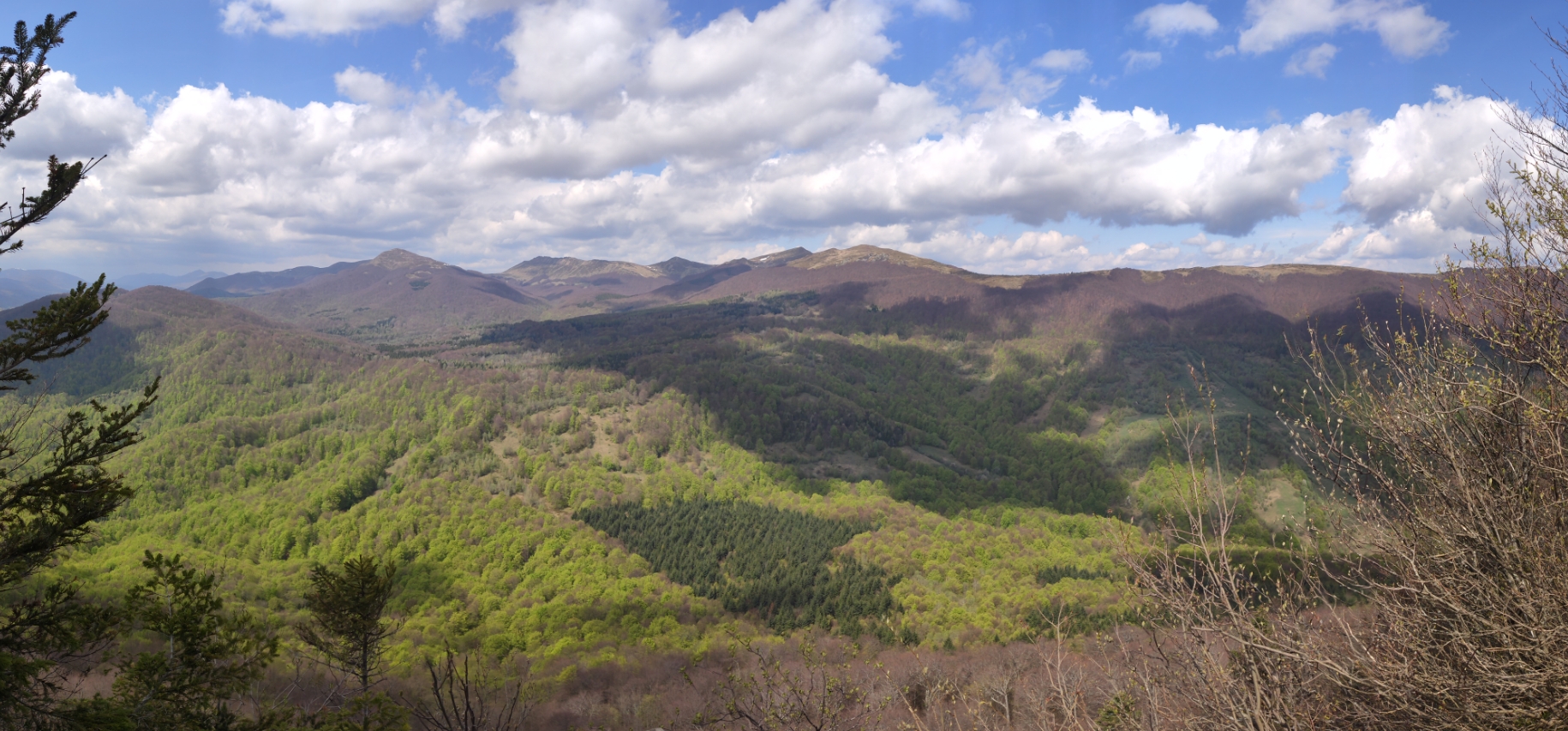
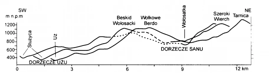
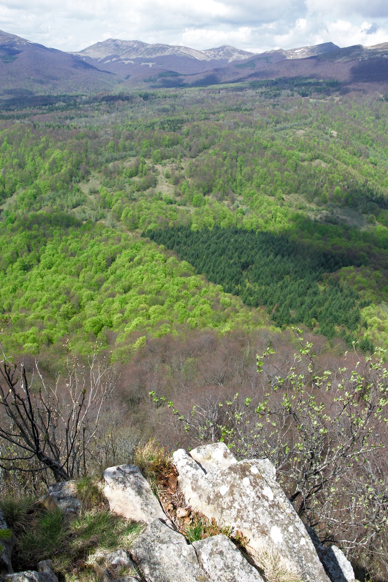
Right behind the Beskid Pass [Пер. Бескид] a landscape changes. Unlike Wołosatka valley, which is really shallow, the Lubnya [Лубня] valley starts really steeply. The major feature of the border range is its considerable asymmetry of the slopes. It refers to Low Beskid [Beskid Niski] and Bieszczady section, where the Great Hungarian Plain cuts most into the Carpathian ridge. Whereas the erosion base for Wołosatka lies at around 650 m.a.s.l. in Ustrzyki Górne, the adjacent stream Lubnya [Лубня], has its erosion base at 430m.a.s.l. only when reaching the Uh [Уж] river (Pic. 8).

With the ridge, asymmetry is associated with another feature. This is a river capture, which in this case will apply to the Wołosatka stream (Pic. 10). In the near future (saying in the geological time) the Wołosatka is going to be captured by Lubnya stream, turning its waters into Uh river instead of San.

Because of the Beskid Bass [Пер. Бескид] is the lowest in High Bieszczady, it was the best place to cross the mountain range from one side to another, as I mentioned above. Threading its way it must have been also a trade way between two regions and also a strategic point for troops, that moved here. In recent times the biggest battle happened during the I World War, when the Russian army struggled to cross this Carpathian border, defeating the Austrian troops. It was after a huge snowfall, in March 1915, when Russian armed forces started to seize Ustrzyki Górne and Wołosate. They marched in 3m snowdrifts upstream the Wołosatka valley, towards the Bukowska Pass [Przeł. Bukowska] in order to reach the strategical Uzhok pass [Ужоцький перевал] with the railway. Austrians stopped them at Opołonek and here, at the Beskid Pass, where an adjacent Menczył hill was strongly defended.
What is happening next? We are in the Uzhanian National Nature Park [Ужанський національний природний парк], which prevents the upper part of picturesque river Uh [Уж] in Transcarpathia. It is a part of trilateral East Carpathian Biosphere Reserve [біосферного резервату Східні Карпати]. This year falls exactly 20 years after this park has been launched. A basic aim of protection is undeniably an ancient and primeval beech forest. These forests in the general stretch between the Czarnohora and Vihorlat Mountains. The age of these trees is estimated at about 4-5 Ka. This is a part of the ongoing spreading process, which lasted since the last Ice Age when these species existed as a single, isolated area near the Alps, Pyrenees, and also the Carpathians. I will describe this phenomenon more in the future.

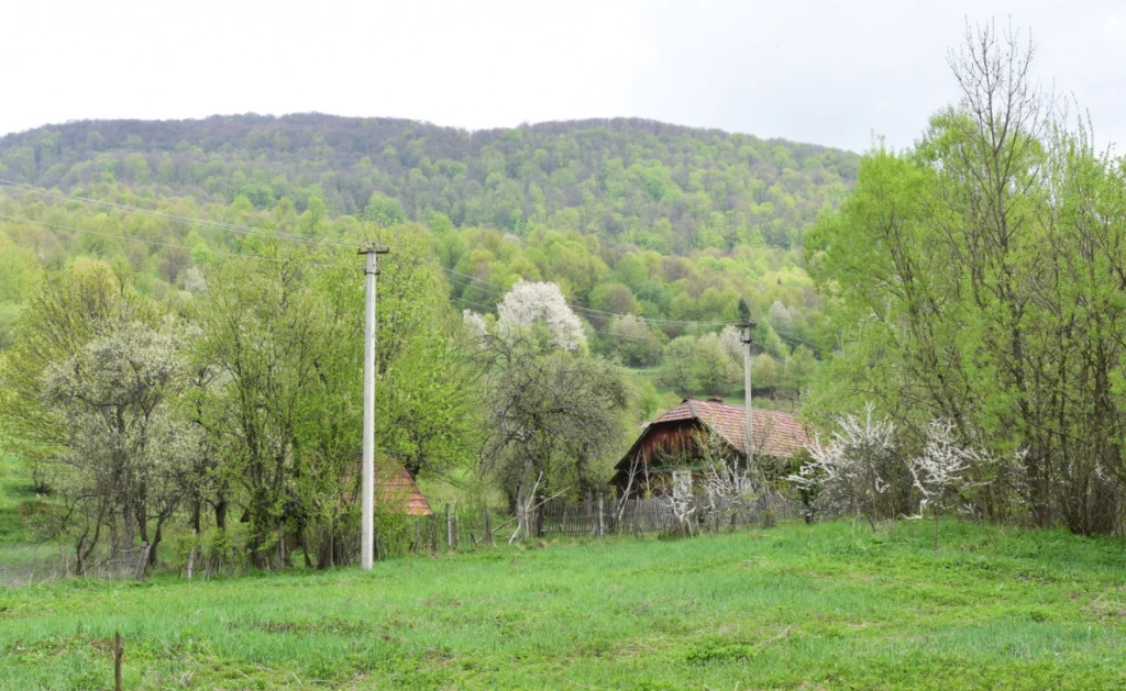
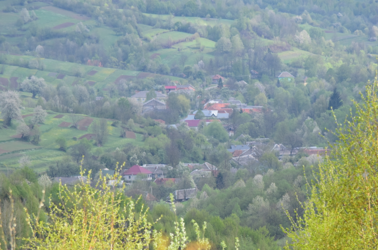
The gravel road descends towards the Lubnya [Лубня] village, which is located about 2,5km from the border. This is the closest village to Poland when considering the Zakarpattia region. The upper part of the road goes into the beech forest (Pic. 11, 13). The lower section, being more tortuous, features a resplendent view both on the upper Lubnya valley and the village (Pic. 12 – 14).


Lubnya [Лубня] was first mentioned in 1631. The name of the village comes from the first settlers, who used to make some items i.e. riddling grates from the bark. The inhabitants mostly grazed the cattle and dealt with forestry work. The village had been inhabited also by Germans, Russians, and Jewish families for a long period of time, up to the Second World War. These Jewish families kept the inn, and shop and also were engaged in bootmaking. According to some sources, about 100 years ago the village was inhabited by around 290 Germans, 280 Russians, 260 Greek Catholics, and 30 Jewish, so it was a much bigger settlement than nowadays. After Ist World War, when Austro – Hungarian Monarchy collapsed, the village, same as the whole Transcarpathia region became a part of Czechoslovakia until the autumn of 1938, then shortly after Carpatho-Ukraine until the spring of 1939, when was seized by Hungarians. During the interwar period, people could feel more free on the border. People from Lubnya have a lot of friends in Wołosate. There were also quite a few cases, when Lubnians took brides from Wolosate, because they lived happier here.
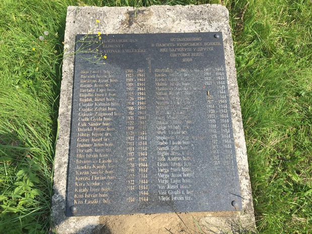
II World War made some changes in the village. Throughout the fascist occupation, a whole Jewish community has been erased. In the autumn of 1944, there was a huge battle, leading to the liberation of this area from Hitler’s occupation. Some part of the village was burned and many soldiers died (Pic. 15).
After liberation, the village returned to Czechoslovakia for a short period, until the summer of 1945, when this region was left under Soviet control.
After the fall of the Soviet Union in 1991, the village became a part of independent Ukraine. Since 1999 Lubnya has been inside Uzhanian National Park.

Today Lubnya is a small village, belonging to Velykyi Bereznyi Raion [Великоберезнянський район]. According to the Ukrainian census, the settlement counts 212 inhabitants only, whereas in 1979 was 562 (Федака, 2014). Almost all are Ukrainians and about half of them are on retirement. There is a small primary school in the village with 5 pupils only. Lots of people left this area i.e. to Uzhhorod, seeking better prospects in life. For those, who stay here, life is tough. The money for some people’s pension is enough for about 2 weeks only. Then they have to take goods for a debt, trying to pay it back in the following month. However, some people cannot agree, that this village is not a perspective. The pivot perspective factor lies 2 km above, the Poland – Ukraine border, which is waiting to be opened permanently. They realize, that the major perspective for this place is tourism. According to them a lot of Polish tourists are reported year by year.
Walking down the main Lubnya street on the 1st of May we could see a big exhilaration. Some tourists and cyclists were passing by the old wooden houses, from which people were watching like ghosts.
I can say without hesitation, that this village is a museum itself. Some sources call Lubnya the village-museum, because of the vast majority of original old Ruthenian houses and farmsteads.

Before I start to show some beautiful houses – and landmarks, I would like to mention a small, wooden orthodox church (tserkva) [церква присвячена пророку Іллі], which stands on a former church, built-in 1890 and burnt down in 1991. We were lucky to get inside this beautiful place because a while ago the tail of some escorted tour was seen a front of us. Probably there was a trip from the Przemyśl branch of the Polish Society of Country Lovers [PTTK Przemyśl], who was making a day trip to Czeremcha Mountain, an opposite one to our destination – Plishka [Плишка]. Anyway, we were fortunate to witness the magic climate of this cozy, saint place (Pic. 17, 18).


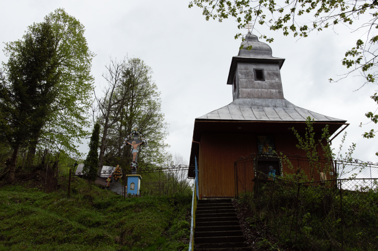
Next to the tserkva, a small cemetery is located, although a newer and bigger one lies further beyond. The orthodox church [церква присвячена пророку Іллі] is definitely the most representative landmark in the village apart from lots of wooden houses and barns. The first one, which stood yet 30 years ago was single-walled with a wooden tent. It was also more beautiful than this one, being more similar to St. Michael Church in Uzhok [Церква святого Михайла].
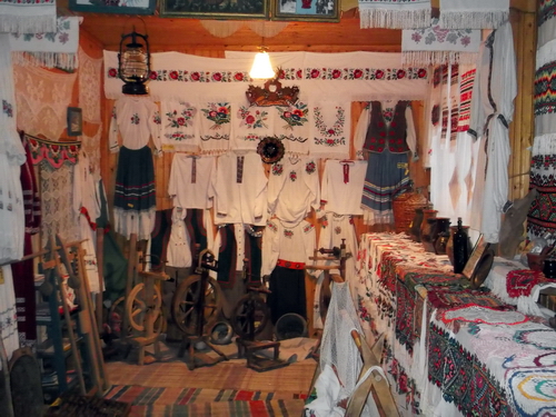
Pointing to other places to see in this village, the room museum [Кімната-музей] would have to be mentioned. We haven’t been there, but there is a nice spot, launched in 2004, where local people leave their day-to-day used items, clothes, and souvenirs, equipping this place finally with about 450 exhibits (Pic. 20).
In the village is also a small Jewish cemetery. If I add up also my point of view I would include old collective farm remnants outside of the village, which can be seen easily from the tourist trail (Pic. 25).


More or less in the middle of the village is one shop, being a living center at once. When we came there was about 12:30 pm GMT+3, so basically, our seamless stroll from Wołosate took 2 hours, taking photos and admiring the landscape in the meantime. We entered this shop on our way back. In the shop vicinity the major, red tourist trail crosses the road (Pic. 24). This is the major trail in Uzhanian National Park, which goes from Stuzytsa [Стужица] village towards the Uzhok Pass [Ужоцький перевал]. This route is quite new, it was marked about 10 years ago by Czech hikers.

As you can see on the map above (Pic. 24), there is an area, which you can cover easily from Wołosate, making a one-day hiking trip only. If you have a bicycle, there is a totally different situation.
A red trail crosses the main way just outside the shop. This is the place, which I visited once before. It was in September 2012, when we came on an escorted tour from the Sanok branch of the Polish Society of Country Lovers [PTTK Sanok], heading on Czeremcha [Черемха] peak that time. I will describe this trip in the future. Now I am planning to focus on my last journey to this region, where a destination I took the Plishka [Плишка] peak.
Taking an overall look at the red route going eastwards, it’s good to mention, that Plishka [Плишка] lies at a 4,5 km distance, which should take about 2 hours to get to the top. To reach a neighboured village Verkhovyna-Bystra [Верховина-Быстрая] we need another 2 km and 1 hour more.
Taking the red trail towards Plishka we are choosing a narrow dirt road, which leads to the farmsteads located behind. After about 300m there is a stream, which can be hard to cross in one step. If you are not confident enough, better take down your boots (and socks) and let’s wade through the shallow, although cold water.

Next another, but much smaller tributary stream must be crossed and immediately afterward our trail ascends steeply, passing by single farmlands and meadows, that offer a nice view of the village.

Every single plot of land has been terraced here in order to make to job a bit easier. It looks like you are climbing the giant stairs. In the meantime from the other side is a nice view of the border hill Menchyl and a huge collective farm Illyich [Ильич] (Pic. 28, 29, 74, 75).


This place is unique, however, we had no time to stop here for long. Plishka was still far away and midday occurred. Because the border was opened for 9 hours only I thought, that Plishka was a priority. Hopefully, it will be time for something extra.
Meadows end soon, and our tourist path climbs further, reaching wide unproductive farmland, that already has been taken by young forest. I believe, that 20 years ago there was a massive grazing area. From time to time a panorama of the nearest summits is looming between the young trees. The road ascends slowly now.

After about 1 km we reached a small ridge, which links a Tower peak [Вежа] with Plishka [Плишка] and the main Carpathian range. The red tourist route starts to climb again, reaching the beech forest. So far we are going on an old unpaved road, which looks like it used to be used from time to time. A way through the forest is not so long, maybe 700-800 meters. Then the landscape changes again, revealing a viewshed towards the east. Our attention is drawn to Tower [Вежа] peak, which protrudes nearby (Pic. 32). Again, this culmination is often mixed with Plishka, because both of them feature very steep summits. What is the reason for their relief? Previously I wrote about an erosion base in the Uh river, that lies much lower than the Wołosaty stream. It incurs an enhanced erosion of surrounding areas, while summits nearby and their slopes. After many thousand years all streams in this area got their beds lower, causing bigger erosion of adjacent slopes, expressed by various mass wasting. As a result, the existing peaks, as we can see today remain single protrusions, as left after a very long period of river modeling. A Tower peak [Вежа] is the main example, as seen from Lubnya village, however, Plishka [Плишка] has the same morphology. Moreover, there are at least a few other summits, which are similar to these two (Pic. 33).


When leaving the forest, the trail suddenly turns left in order to avoid a small valley stretching down to Verkhovyna-Bytra [Верховина-Быстрая]. Weather is improving, even towards the Ukrainian mountains, making them visible. However, this is still not a proper time to see them, due to massive clouds capping their tops.

Hopefully, they will be visible on our way back later. Carry on then. It looks like the trail is very little visited. Except for a few, although clear marks on random trees, there is no path at all since we turned left. Only grass is trampled in places, which assures us, that we are heading in the right direction. Apart from it, the Plishka summit [Плишка] became clearly visible, when we made a turn (Pic. 35).

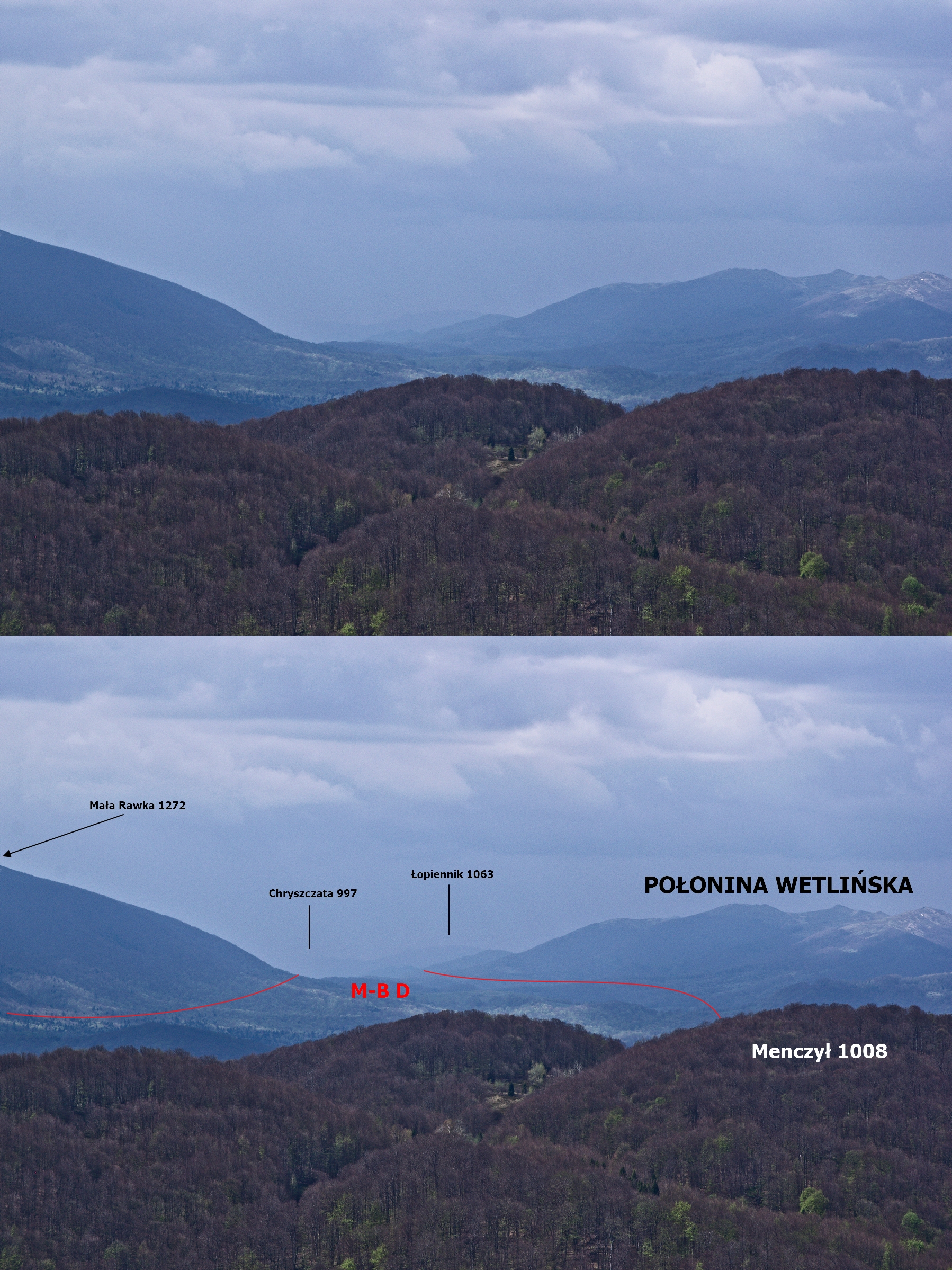
Plishka [Плишка] is a very interesting summit from a geological point of view. Looking at this mountain from the west, we can spot a huge asymmetry between the north and south slopes. This situation arises out of the features of the Połoninas range. Unlike the Tower [Вежа] and Czerenina [Чeрeнина] peaks, which are comprised of the Dukla nappe flysh rocks, Plishka represents an opposite section, which lies on the other side of the Mid-Bieszczady Depression (Pic. 36). The Mid-Bieszczady Depression continues here from Ustrzyki Górne and Wołosate, down to the Verkhovyna-Bystra [Верховина-Быстрая] village, making the Moshka [Moшка] valley quite wide. The area, from where picture 35 was taken also lies within the aforementioned Mid-Bieszczady Depression, which is carved by less resistant rocks of the Fore-Dukla Zone (Bąk, Haczewski, Kukulak, 2007). This geological section is overlaid by thick-bedded cretaceous sandstone series building up the Dukla Unit.
In general, the whole Outer Carpathians are made of a stack of nappies, being visible in the field. It has been reflected in their relief, what is to be seen even on the typical topographic map.

All zones in this area have a ridge orientation from northwest to south-east. Moreover, the strata, in general, are tilted at about a 30-40-degree angle towards the southwest, from where these tectonic units are overthrust one on the other. It is perfectly translated into local relief. It is enough, when we look just at the summit appearance, we can spot, that their north-east slopes are much steeper than the south-western ones.
The red trail starts to descend a bit, leading us between Juniperus shrubs. On the north horizon, Polish Bieszczady and Polonyna Bukovska are visible.


After maybe 500m the trail starts to ascend again. You must be attentive here because is easy to get lost. There are no significant trail marks on this section due to the large density of shrubs. It’s good to remember the picture above. If you go there in the spring, try to find a medium cherry tree, which should be a good waypoint for you.
Being nearby, we heard and next caught another group, walking the red trail. It was at least several people from different parts of Poland, who were taking part in one week’s trip to Uzhanian National Park. They started in Velkyi Bereznyi town, then proceed via Jawornik summit to Stuzyca village, which is the remnant of the biggest meteorite falling in Europe (Kniahynia meteorite). Then proceeded on Czeremcha hill, down to the Lubnya, and headed to Uzhok Pass and Polonyna Bukovska beyond. We were going with them for a while, having a nice conversation with the leader of this group, who brought me some details about yourself. His team is called “A Workshop of Unconventional Journeys (Montownia Wojaży Nieszablonowych)” and organizes long hiking trips, mainly on Eastern Carpathians.
We couldn’t be for long with them, because the red trail firstly bypasses the western slopes of Plishka, and then makes a hard left towards the summit. Because they were guided by the service of the Uzhanian National Park, they could walk outside the hiking routes. We split at the small pass near Czerenina hill. This place is very beautiful because you have a wide view of the Moshka [Moшка] valley and Eastern Bieszczady [Схі́дні Беща́ди] beyond. The detailed view will be later because we were in a rush to reach the Plishka summit as quickly as possible.
Primarily, the trail ascends gently, however after a few hundred meters road becomes steeper. Climbing onto the hill I met my students from High School, who I taught entrepreneurship 6 years ago. They enjoyed an amazing view from the Plishka. It motivates us to reach the top more quickly. However, we couldn’t really do it, because the view from the southern lope was also amazing. As we climbed higher, the new mountain ranges started to be visible. On top of that, the weather became more clear.

Beside the beautiful panoramas possible to see through the rare forest we spotted a huge landslide (Pic. 41).

Landslides are very common in the Outer Carpathians, which are comprised of flysch rocks. Flysch rocks include both a sandstone and shale series. Shale rocks are very plastic and evolve a lot of mass wasting after long-term precipitations. Sandstone formations with soil, lying above move down to the slope, causing a huge deformation in relief or even destroying some households. Sometimes these forms can create landslide dams, which are popular in Bieszczady Mts.
The last section, between a landslide and the very top, is also very interesting. At a whole distance, it is covered by ancient beech forests. Moreover, the red trail leads now to a ridge. We can see rocks, that build up the Plishka summit.

The Plishka mountain [Плишка] is composed of Krosno Beds, which are represented by about 2000m thick layer within a south-western edge of the Central Carpathian Depression This Central Carpathian Depression covers most of Bieszczady Mts and its south-western edge goes on the line Menczył – Plishka – Kleva – Czolovyczok, described here. In this section, the Krosno Beds layer features rigid thick-bedded otryt-type sandstones. Every single layer of this medium to coarse-grained sandstone counts from 10 up to 50cm.
These thick layers of sandstones are separated by thin layers of mudstones and dark grey shales, making a flysh, characteristic of another Krosno Bed layer. However, this flysh is usually placed between huge packages of otryt sandstones, in which a single layer may reach even a few meters, which is to be seen i.e. on neighbor Bieszczady Peaks on the Polish side. The age of these rocks is Oligocene (between 34 and 23 Ma).
Despite the rocky landscape of the north Plishka’s slope, all the area is covered by vegetation. As a result of a very steep surface, the trees are under a permanent downward progression. It can be seen once the red trail turns the ridge direction (Pic. 44).

After about 200m trudge uphill, the red trail leads us to the right to the top. Really, the view is awesome. A viewshed from the top covers exactly a whole High Bieszczady Mts located in the south-easternmost part of Poland (Pic. 45).

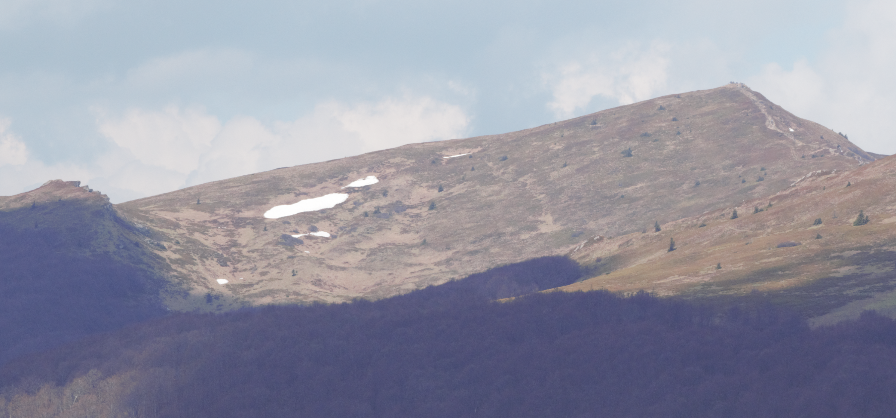
Having this view a front of my eyes I could delight in the landscape and major elements of relief. The biggest phenomenon of Bieszczady Mts is the lack of forest from about 1100-1150m.a.s.l. Extensive mountain crests rising above treeline display relief, that reflects large-scale tectonic structures (Bąk, Haczewski, Kukulak, 2007). Before I start to describe major relief elements, which can be really easily seen from the Plishka hilltop I would like to answer quickly the question: Why the Bieszczady Mts doesn’t have a forest on the top.
This is a widely common problem arisen by many botanists and ecologists and is commonly known as the Carpathian disjunction of Norway spruce. It has been found, that Norway spruce is naturally absent in the Carpathians in Beskid Niski and Bieszczady Mts. It was explained by the lack of suitable climate conditions (Tjorkel, et al., 2007), where a key role plays hot and dry southerly winds. Another factor, with the historical background, is somewhat related to the first one. It says, that the spruce forest disappeared after the Wallachians migration, who inching alongside the Carpathian ridge were making slash-and-burn agriculture. Afterward, the spruce forest wasn’t able to recover.
Because of the lack of forest on the mountain tops, these ridges look intriguing, compared to mountains in another part of the Polish Carpathians.
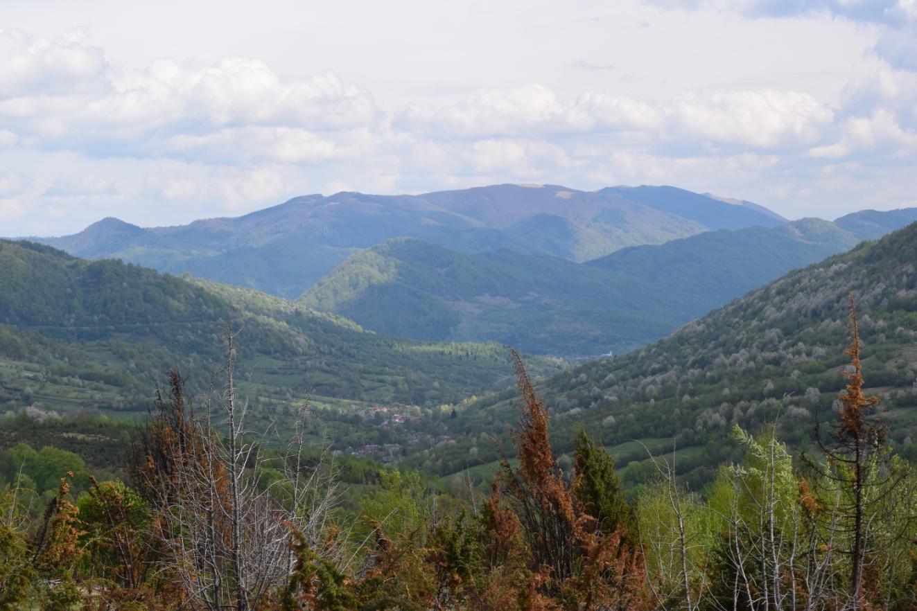
Considering major elements of relief is worth pointing out a few pivot places (views). The most visible and streaking view towards the west shows a huge tectonic zone, which is a Mid-Bieszczady Depression, continuing from Wetlina to Verkhovyna-Bystra village (Pic. 46).

In general, the relief of the Eastern Carpathians, where Bieszczady lies is structural. This relief is controlled mainly by the difference of the resistance rock series to weathering and erosion. The pattern of mountain crests consists of a long parallel ridge, linked with low passes (Bąk, Haczewski, Kukulak, 2007). From Plishka we can see a few extended mountain ridges in orientation from southeast to northwest, especially in the case of Wetlińska and Caryńska Polonynas.

These ridges are dissected by deep gorge valleys, perpendicular to the main structural orientation. The nearest one is Wołosaty valley, which lies between Szeroki Wierch and Polonyna Caryńska ranges. Its presence is expressed in the general landscape, where Połonina Caryńska looks distinctively further than the closer crest community (Pic. 50).
Other mountains look also interesting. For instance, Krzemień features a lot of ridge sandstone rocks 8-10m in size, which makes this mountain different from others (Pic. 52). Moreover underneath there are a lot of small crags, parallel to each other.

Many slopes have been modeled by landslips, which are popular in flysh structures, which I wrote about before. These landslides strongly transformed the mountain landscape both in large-scale and local-scale landscape elements. The most remarkable landslide, which can be easily seen from Plishka is located underneath the Halicz summit. This landslide looks interesting because of the shape of the bed (Pic. 52).
At the bottom of this landslide, there are a lot of colluvias, whose heights reach sometimes 10m.
Sometimes these mountains are criss-crossed by trenches. Quite often another form like scouring or talus caves can be also spotted. The most representative next to the landslips are sandstone protrusions, slid rocky massifs, and screes (Pic. 53).

In the end, I would like to show other interesting images.

It was hard to spot Kinchyk Bukovski [Kińczyk Bukowski] 1251 m.a.s.l – the highest peak of the western crest of Polonyna Bukovska and also the highest peak of the Uzhanian National Park. The viewshed ends somewhere westwards (Pic. 54). You can try to see it staying on a rock, which is risky because the escarpment has at least 30 meters.
We were there on 1st May, so it was springtime. From the top, we could see how the vegetation is progressing on different levels of altitudes. Basically above 1000m.a.s.l. the beeches were still without leaves developed. Beneath this altitude it was slightly better, however, bigger progress could be noticeable on the Ukrainian side of the forest (Pic. 55).
I can admit, that view on the Bukowska Pass [Przeł. Bukowska] was awesome. I remember when I was there almost 12 years ago. Then I saw a boundary post from a few meters distance and Plishka peak beyond. Now it was exactly another way round!

What was the best at the top? Silence! No one was there, except me and my friend. Unlike to Tarnica summit, which is also busy (Pic. 57).

The view was really nice and the rest or meal, obviously needed. However, when I checked the time I realized, that there were not many hours left before the border closure. It was about 3:30 pm UTC+3 when we left the summit. Long way to go back, although maybe we take another rest somewhere…

We descended quickly to the pass underneath the hill. In the meantime, the remote parts of the Ukrainian Carpathians [Українські Карпати] were much better visible than before.


We stopped for a while at the pass, to see the landscape of Verkhovyna-Bystra [Верховина-Быстрая] environs with mountains beyond.
Verkhovyna-Bystra [Верховина-Быстрая] is nearly 4 times bigger than Lubnya. It counts for over 820 inhabitants. Beyond the village we could see an eastern ridge of Polonyna Bukovska [Буковецька полонина], belonging to Eastern Bieszczady Mts [Схі́дні Беща́ди], which is separated by Uzhok Pass [Ужоцький перевал] from a western part with Kinchyk Bukovski [Kińczyk Bukowski] mountain. In the stretch of Polonyna Bukovska [Буковецька полонина], the highest peak of Bieszczady is situated. This is the Pikuj [Пікуй] (1406m.a.s.l), which is the rightmost, partially hidden summit with a pinnacle on the top (Pic. 63). Worth to mention is also a Starostyna [Старостина] summit (1229m.a.s.l.), located more or less in the middle and the Drogobytskyy Stone [Дрогобицький Камінь](1186m.a.s.l.) leftmost peak with small patches of mountain meadow on the top.

If you look carefully at the picture above, you can see another village located further down from Verkhovyna-Bystra. This is Volosianka [Волосянка] village, known for a train station, where tourists usually terminate their scenic journey through Uzhok Pass from Sianki [Сянки]. The village has quite a prominent Orthodox church seen from the distance (Pic. 65).

Vis-a-vis a Pikuj peak, separated by deep Roztoka valley rises another prominent peak. This freestanding mountain is Ostra Hora Mt. [Гостра Гора] (1407m.a.s.l.) located exactly between Polonyna Runa [Рівна] and Pikuj [Пікуй] (Pic. 67).

We were returning exactly the same way, as we came on the top. We didn’t want to wander aimlessly between the shrubs and waste precious time. When we approached the forest covering the ridge connecting the Tower peak, I spotted a couple of frontier hills, located in the western part of Polonyna Bukovska [Połonina Bukowska] (pic. 68). There are visible Stinska and Rozsypaniec Stinski summits, not really prominent in the Kinchyk Bukovskyi [Kińczyk Bukowski] community, however very interesting in geomorphological and botanical point of view.

We approached the meadows above Lubnya village at about 5 pm GMT+3, so it was enough time to have some rest before walking up to the border checkpoint.

Meanwhile, we could admire a resplendent panorama of Lubnya village [Лубня] from the south (Pic. 70-72).


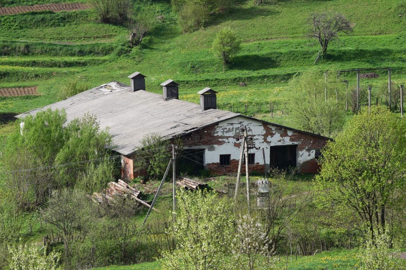
Lubnya [Лубня] features a typical silent and rural landscape. Agriculture has been the main occupation for years. During the Soviet Union period, the village was running a collective brigade Illych [Ильич], whose remnants are still visible (Pic. 73, 74). In the highest development period, this collective farm was owed 262 hectares of agricultural land, where 45 hectares were arable grounds and another 78 hectares of grass for haymaking. All these areas were located around the village, i.e. in the area, where today a red tourist trail crosses a young forest (Pic. 31). A brigade was specialized in growing heifers. For high performance, 7 people from the village were awarded orders and medals from the Soviet Union. After the fall of the Soviet Union, this enterprise has been dissolved. Remnants of this time are massive unproductive farmlands around the village, especially on higher lands and a lot of field terraces, which from the distance look like a green stair (Pic. 75). They did their best to make these plots of land as much profit as possible.
Nowadays agriculture is rather confined to private necessities instead of massive deals. Lubnya was running also a sawmill, however, due to a lack of demand was also closed.


When we left the red trail, it still was some time to spend. We decided to enter the shop for a while. As I said previously this is the main place in the village. This is a wide building, which holds both a shop and a restaurant. The shop is very small, but you can find there all 🙂

Time to go back definitely! It was around 5:30 pm GMT+3 when we left this cozy shop. We had to ascend 2,5km to the border point. Moreover, the weather started to get worse. We were wet on our way back.
Climbing towards the pass we could still see the Tower [Вежа] summit when turned our heads back.

On the border, everyone was gone. We entered Poland easily at 5:15 pm GMT+2. Our one-day trip journey to Uznanian National Park from Wołosate was over. Unfortunately, we didn’t realize, that in Wołosate was so bitterly cold! To the car park left about 20 min. I guess.

On our way to Wołosate, we had a nice conversation with a Romanian guy, who missed the road and was asking about some directions. Afterward, he was talking about Transilvania, Przemyśl, and something about Hungarians. The discussion was lovely, although we were in a rush because it started raining.
Fortunately, we weren’t much wet, when sat in the car again. Though the weather was the same dull as in the morning. It was about 6:30 pm GMT+2 when we set in a return way.
3. HOW TO GET THERE?
In the last part of my article, I would like to point out a few pieces of advice shortly, how to get into this area. Now I am only pointing to a major way, as we can use to get to Wołosate. In the future, I will describe it better.
The easiest way to go here is by plane to Warsaw Chopin Airport (WAW) or directly to Rzeszow Jasionka Airport (RZE). From Warsaw Chopin Airport (WAW) you can both fly to Rzeszow (RZE) or take the Neobus coach, who takes you to Polańczyk or at least Sanok. From there (especially from Sanok) is an easy way to catch some bus, which should operate at least once a day all year round, and obviously more often in the period July 1 – August 31. Once you touch down in Rzeszów Jasionka (RZE) you can catch the bus or hire a taxi to Rzeszów coach station, from where you easily get transportation to Sanok.
If you want to hike in Uzhansky National Park directly, which can be more useful once Poland Ukraine border is still closed, then better will catch the plane to Danylo Halnytski International Airport in Lviv (LWO) (quite a few connections from Warsaw Chopin WAW Airport), catch some transportation to the Lviv main train station and then go by train to Sianki (in order to reach Uzhok Pass and get to the red trail described in the article) or directly to Stavne village, which is adjacent to Lubnya. Remember, that bus to Lubnya operates only twice a week. You can use a blue trail alternatively, which leads you via Beskydec Mt to the shelter (Pic. 24), where you easily join the red trail between Czeremcha Mt and Lubnya.
Another way is a flight to Kosice International Airport (KSC) or Debrecen Airport (DEB), from where it should be relatively easy (within 1 day) to reach the Uzhhorod – the Zakkarpattian capital. Then you can try to catch a lot of local transportation at least to Velkyi Bereznyi town and jump to the tourist red trail mentioned above.
Mariusz Krukar
References:
- Bąk K., Haczewski G., Kukulak J., 2007, Geology and relief of the Bieszczady National Park, Pedagogical University, Kraków (Polish).
- Bąk K., et al., 2001, Exotics-bearing layer in the Oligocene flysh of the Krosno beds in the fore-Dukla zone (Silesian nappe, Outer Carpathians, Poland), (in:) Geologica Carpathica, vol. 52, i.3 p. 159-171.
- Brandos O., 2010, Ukrainian Carpathians, Transcarpathia, Polonynas, tourist guide (Ukrajina, Ukrajinské Karpaty a Poloniny, průvodce), Praha
- Федака C., 2014, The population density of Zakarpattia region and single villages: A historical and geographical guide (Населені пункти і райони Закарпаття: Історично-географічний довідник), Poligraphcentr “Lipa”, Uzghorod (Ukrainian).
- Klimczuk A., Klimczuk-Kochańska M., Plawgo B., 2015, The cross -border cooperation of small and medium-sized enterprises as a Factor in Regional Development. The Example of Sub-bialystok-suwalki and Sub Krosno-Przemyśl in Poland, the Circuit Carpathian Ukraine and Belarus Grodno Region, Białystok (Polish).
- Mrozek K., 2016, Pedestrian border crossings. Diagnosis, arguments and recommendations, The Stefan Batory Foundation, Warsaw
- Ralska-Jasiweiczowa M., 1980, Late glacial and holocene vegetation of the Bieszczady Mts (Polish Eastern Carpathians), PWN, Kraków (Polish).
- Ślączka A., et al., 2006, The General Geology of the Outer Carpathians, Poland, Slovakia, and Ukraine, (in:) Golonka J., Picha F.J., The Carpathians and their foreland: Geology and hydrocarbon resources: AAPG Memoir 84, p. 221-258
- Tjolker M.G., Boratyński A., Bugała W., 2007, Biology and ecology of Norway spruce, PWN, Poznań
Links:
- 2007-09-24 Statement of scientific council of the Bieszczadzki National Park about the Wołosate – Lubnya border crossing (Polish)
- 2009-05-18 A big plans of Ukrainian councils for border crossings with Poland (Polish)
- 2013 Not enough money for new border crossings with Ukraine (Polish)
- 2015-12-08 Ukrainian – Polish border crossing point at Zakarpathia. A fact or jut words? (Ukrainian)
- 2017-09-08 The location of the future checkpoint between Transcarpathia and Poland was shown online (PHOTOS)
- 2017-09-11 After the Krynica Economic Forum declaration. Where a new Poland – Ukraine border crossings are going to be created? (Polish)
- 2018-09-19 Carpathian Days of Friendly Neighbour. Meeting at the border (Polish)
- 2018-09-20 Will the border crossing in Wołosate be created? (Polish)
- 2019-05-14 5-days border crossing Łubnia – Wołosate (Polish)
- Will the border crossing in Wołosate be runned for tourists? (Polish)
- IUCN Red List of Threatened Species
- Summitpost.org: Western Bieszczady info
- Summitpost: Issues with international borders
- Estimating waiting times on the Poland-Ukraine border
- Wołosate history of the church, parish and cemetery (Polish)
- Wołosate previously and now – history about the settlement (Polish)
- I World War in Bieszczady (Polish).
- Carpathian land: Uzhanskyi National Park
- East Carpathians Biosphere Reserve
- UNESCO: East Carpathians info
- Ancient and Primeval Beech Forests of the Carpathians and Other Regions of Europe.
- Lubnya, Zakarpatska Oblast (Ukrainian)
- Lubnya – info about village (Ukrainian)
- What is a riddling grate?
- Trekking.cz: A brand new tourist guide for Ukrainian Carpathians (Czech)
- Central geological database for Poland
- Travel.Stakexchange.com: How is the land border between Poland and Ukraine?
- Forum.Bieszczady.info: Wolosate – Lubnya
- Tripadvisor.co.uk: Poland to Ukraine… on foot
- Facebook.pl: Polish foot border crossing
- Facebook.pl: Stefanówka Bieszczady, I World War in Bieszczady (Polish)
Wiki:
- Ancient and Primeval Beech Forests of the Carpathians and Other Regions of Europe
- Bieszczady Mountains
- Carex_pauciflora (few-flowered sedge)
- Carpathian Ruthenia
- Carpatho-Ukraine
- East Carpathian Biosphere Reserve
- Eastern Carpathians
- Main Beskid Trail
- Poland – Ukraine border
- Velykyi Bereznyi Raion
- Vlachs
- Zakarpattia Oblast
Youtube: