
The magic Cornwall – part 2 small and big “cornish loop”
I am in a rush with fantastic pictures and memories from the time, that I spent in Cornwall. Previously I sketched out both my trips. Now I would like to continue by describing a small and big “cornish loop”.
It was 3rd day of our 2nd journey to Cornwall, Monday. We slept in YHA Lizard Point and next carried on our trip. We made something like a “big cornish loop” that day and a similar “small cornish loop” on the following day (detailed here).
8. Kynance Cove & Beach
Kynance Beach is the most photographed and painted location in Cornwall, the contrast between the cove’s white sand beach and the dark red and green serpentine rock produces a breathtaking sight.

Pic. 1 The Kynance Cove sight.

Pic. 2 Zoom into Kynance Cove with a fair sandy beach, 55 mm.
During the low tide, you can explore the sea stacks or go inside Kynance Cove and a few other nearby coves closely located.
9. Pendennis Castle
Pendennis Castle is located outside Falmouth town. This is the amazing artillery constructed by Henry VIII in the 1540s, located at the end of the peninsula. The fortification includes the original XVI-century Device Fort surrounded by massive outer defences. Closer to the shore you can see well-preserved gun batteries and a blockhouse.
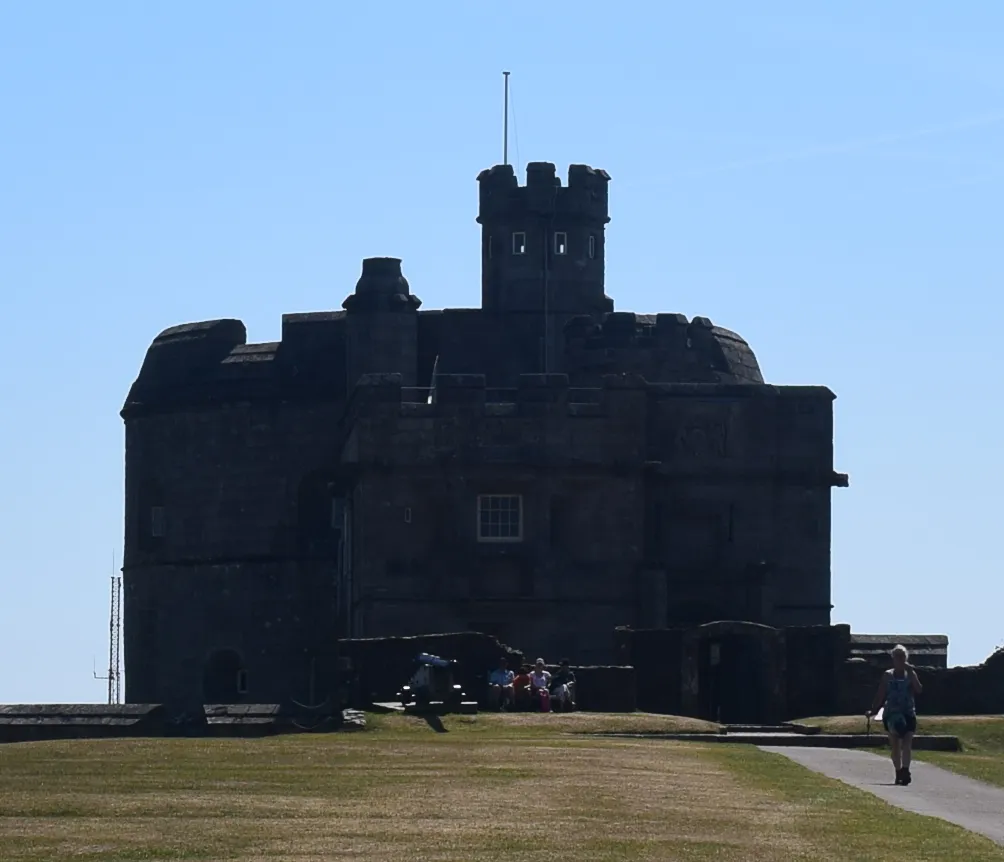
Pic. 3 Pendennis Castle, an example of XVI-century defence construction.

Pic. 4 The gun batteries headed on Carrick Roads canal.

Pic. 5 The Carrick Roads canal seen from Pendennis Castle.

Pic. 6 The Falmouth town seen from Pendennis Castle.
Read more:
10. Mevagissey
Mevagissey is a cosy fishing port located in southeast Cornwall. This village has only 2k inhabitants. The most remarkable place here is the harbour. You can also take a short walk through the narrow lanes and passageways inside the village. The way from St. Austell to Mevagissey is also picturesque and leads along the shore.

Pic. 7 Mevagissey – view on the harbour.
11. Eden Project
Eden Project is one of the most popular places in Cornwall. This is a botanical complex, dominated by two huge enclosures consisting of adjoining domes, that house thousands of plant species. The biggest and the most remarkable in my opinion is the tropical biome, which covers more than 1.5 ha. Be ready for GBP 25 admission!

Pic. 8 The Eden project.

Pic. 9 The plants from South Africa housed in the Eden Project.

Pic. 10. The tropical biome in the Eden Project.
The Eden Project came into being in 2005. It had been built for several years in the former clay pit, which had been used there for more than 150 years.

Pic. 11 The Mediterranean section in the Eden Project with some restaurant facilities beyond.
Read more in the link below:
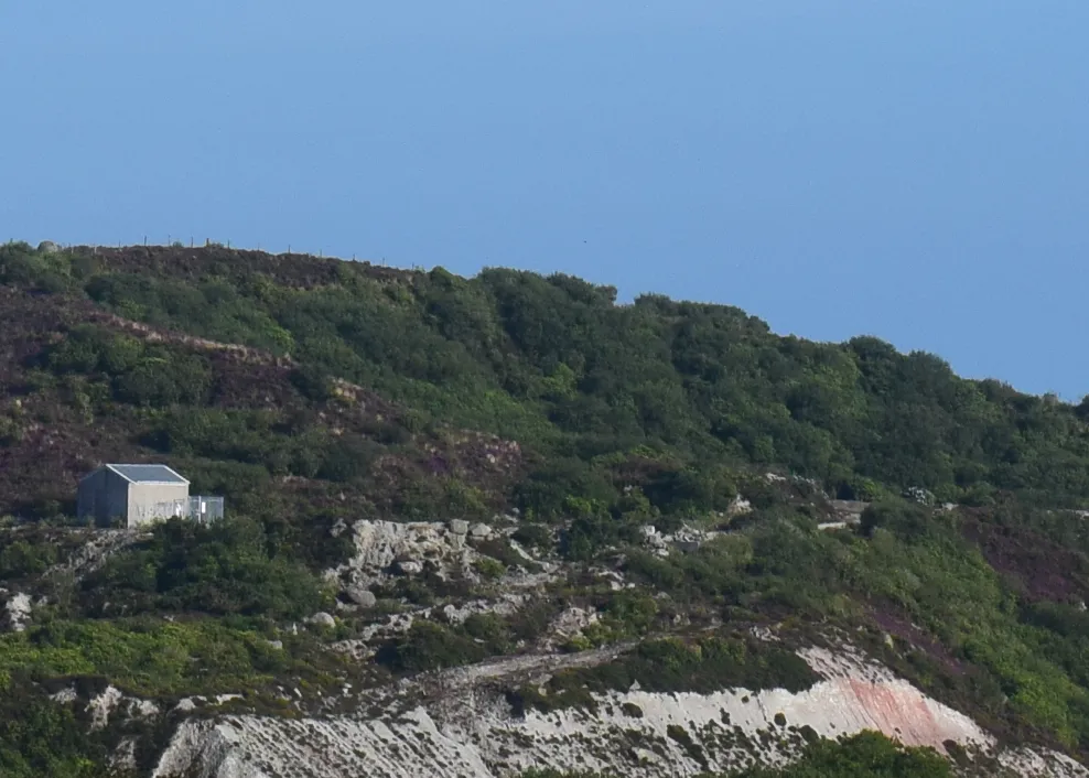
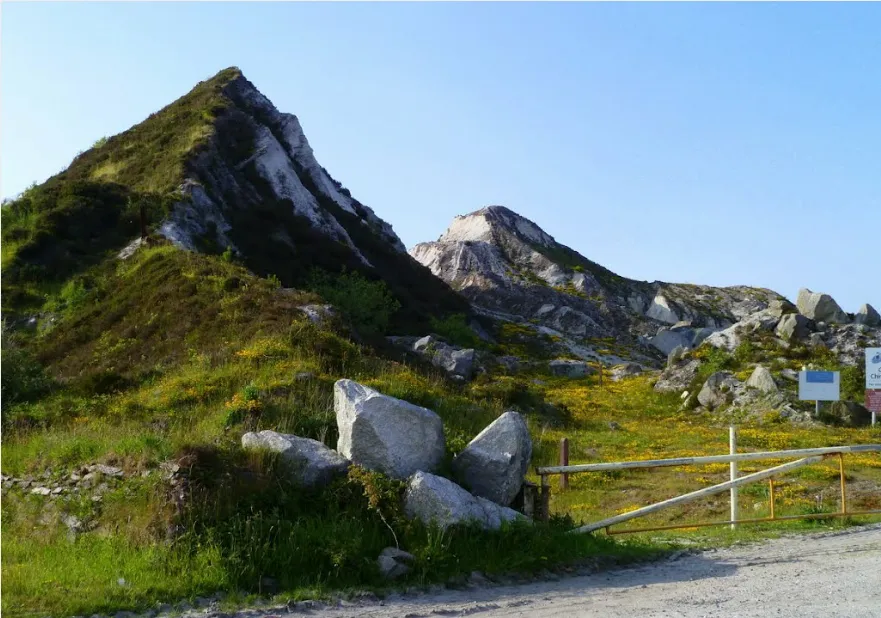
12. Cornish Alps
The Cornish Alps is called the highland region between the A30 express road (villages Summercourt, Fraddon) and St. Austell. The highest mountain there is Hensbarrow Beacon, which rises around 300 m above sea level. These euphemistically named “mountains” are the debris of China’s clay mining, which has been the backbone of Cornwall’s economy for the last 250 years. This is probably the best-known source of china clay in Europe. Those sharp, fearful peaks dominate the surrounding landscape. Under China, clay hides the kaolinite clay. This rock develops in the areas of chemical weathering of rocks in hot and moist climates e.g. tropical rainforest areas.

Pic. 12 The Cornish Alps area in Google Earth.

Pic. 13 The Cornish Alps area near Witemoor seen on Google Earth.

Pic. 14 The Cornish Alps near Karslake village seen from bird’s view (Andrew Turner, flickr.com).

Pic. 15 One of the sharp peaks in the Cornish Alps near the Hensbarrow Beacon area.
Pic. 16 The Cornish Alps landscape.

Pic. 17 The Cornish Alps landscape (James Stringer, flickr.com).
Pic. 18 The Cornish Alps landscape near the Stenaless village (Margit Berger, flickr.com).
The best view is from the south. The best access to this area is from St. Austell town, which lies just a few scant miles from the Cornish Alps. Leaving the town you need to go towards Stenalees village and next to Roche village. I can’t advise you on local roads, because some of them may be out of use. This place was the most desired visit for me as a geographer. For people, who don’t want to waste time to find a decent view inside the Cornish Alps I strongly recommend road A390 to Truro or road A3058 from St. Austell to Newquay (pic. 20). When you back from Mevagissey is also a good opportunity to see the most representant part of this odd mountains.

Pic. 20 The Cornish Alps seen from the A3058 road (flickr.com).
Read more:
All about the china clay industry in Cornwall
13. Newquay
Newquay is a small town located on the North Atlantic shore. We didn’t have enough time to visit the town centre. We went to the beach only. I can admit, that beach in Newquay is really nice. This is Lusty Glaze Beach, located in the north part of the town. The access is quite easy. The local airport is only 5 miles. If you are going A30 from Bodmin you must head on A39 and next in Trevarren choose A392. Just before the entrance to the Newquay head on Trevenson Road, next to Henver Road and Arundel Way. Next, you can think about parking your car and next, you go directly to the seaside.

Pic. 21. View from Porth Beach Padlock Bridge towards the north.

Pic. 22 Newquay town is seen from Porth Beach Padlock Bridge.
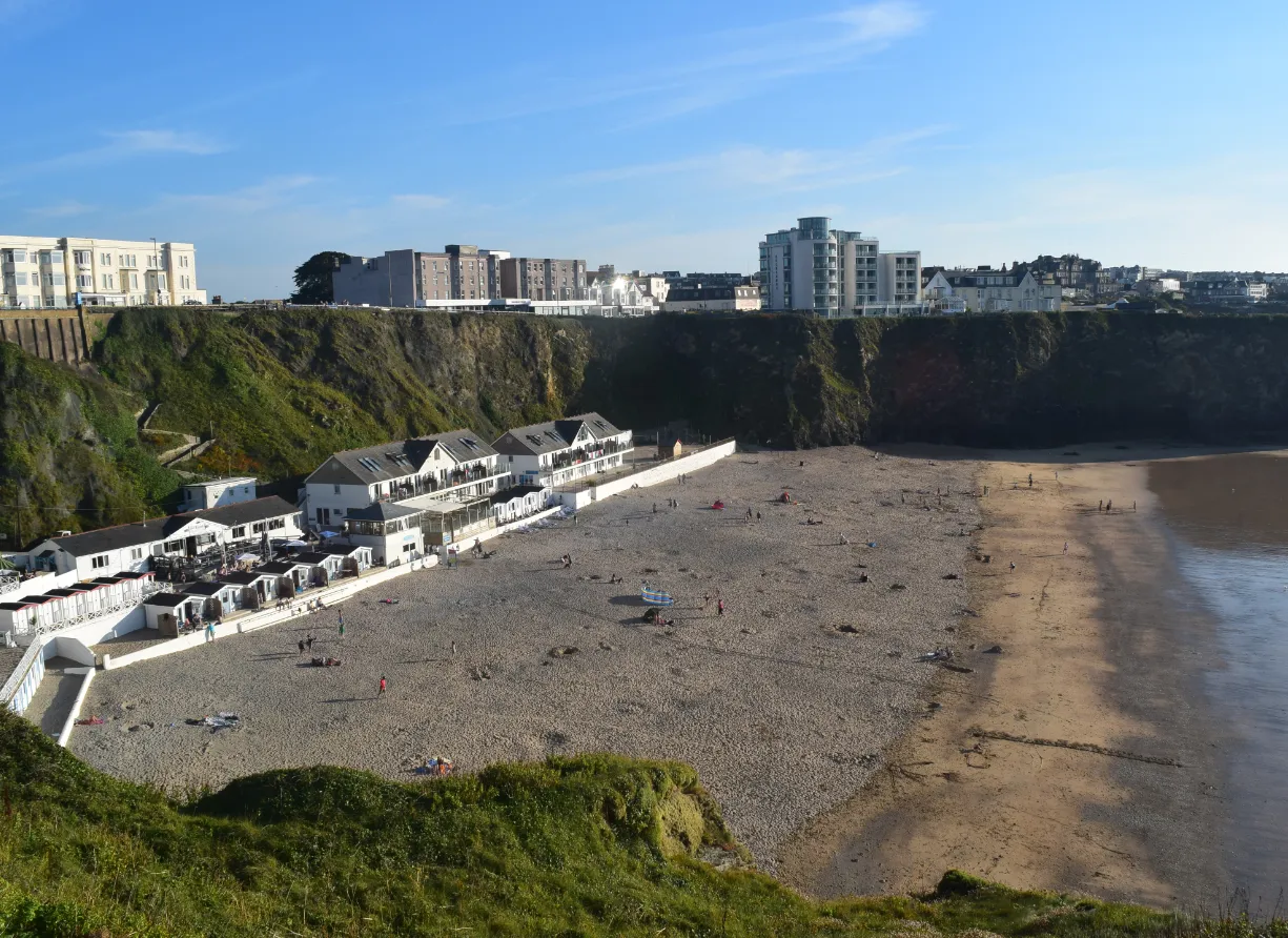
Pic. 23 View on the Lusty Glaze Beach.
Lusty Glaze Beach is the most popular beach in Newquay. You have a lot of accommodation here.

Pic. 24. Lusty Glaze Beach accommodation.

Pic. 25. Lusty Glaze Beach – the cove and surroundings.
Read more also below:
That’s all for the one day commenced in Lizard Point. After Newquay, we headed to our tent camp located near Land’s End Airport. The next day on Tuesday 15.08 we managed to a small “cornish loop”.
14. St. Michel’s Mount
This is the flag place in Cornwall. Everyone, who is going here wants to see the small tidal island with a beautiful castle on the top. The civil parish community on this island counts 35 people.

Pic. 26. St. Michael’s Mount seen from the Mount Haven Hotel terrace, 135 mm.
There is a problem with seeing the Mount from the centre of Marazion. It’s good to go to some coffee or a hotel to have a beautiful view of the mount. We found one. It was a coffee in the Mount Haven Hotel, located just outside the town. There was a perfect view of St. Michael’s Mount from this elevated place.
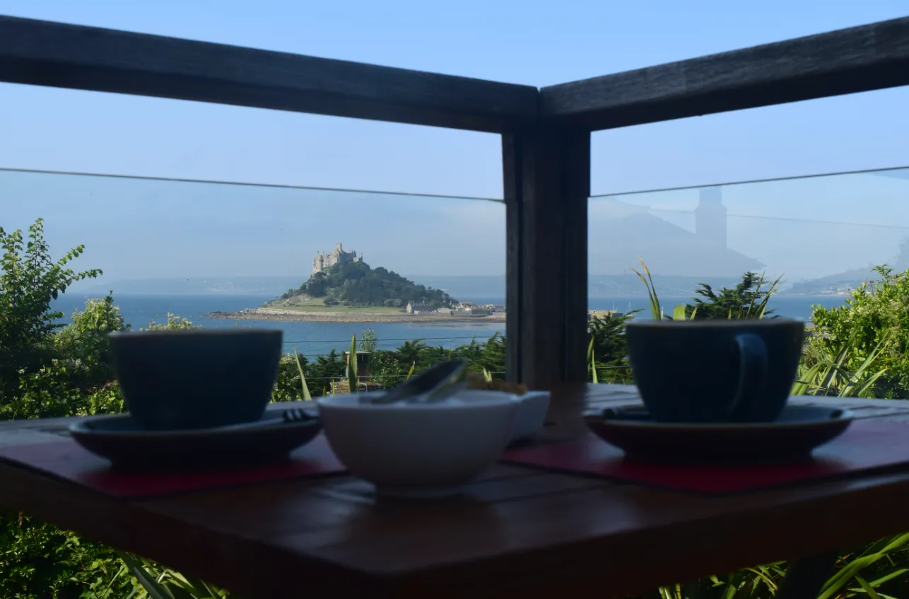
Pic. 27 Coffee time with a picturesque view of the St. Michael’s Mount from the Mount Haven Hotel Terrace.
The St. Michael’s Mount is linked with the Marazion town by a man-made causeway of granite setts, passable between low tide and mid-water.

Pic. 28 The St. Michael’s Mount seen during the low tide near the cobbled causeway.

Pic. 29 Near view of the castle, 55 mm.
You can enter the Mount area, however, admission to the castle on the top is payable. This object belongs to the National Trust. We enjoyed seeing the castle from the bottom. Moreover, you can enjoy a good view of the surrounding area. Penzance and Marazion town are clearly visible from this place.

Pic. 30 View on the Penzance city centre with the most prominent building housing the Lloyds Bank today, 300 mm.
Read more also below:
Everything about the St. Michael’s Mount
St. Michael’s Mount – a sacred place in Cornwall
St. Michael’s Mount – National Trust main page
15. The Porthcurno beach
Some people think, that Porthcurno is the best beach in the whole of Britain. The area is stuck between two vast rocky walls and then continues by a small gully extended towards the village centre. This is an amazing triangle-looking sandy beach. Two main downsides of this beach are weather and seawater temperature. We were lucky because, during our 4-hour stay, the weather was really nice, except for the quite strong wind, which was generating big waves (I enjoyed it). Nevertheless, you should remember, that in this place all year round rain takes hold and a temperature higher than 25 deg happens only rarely! It influences the seawater temperature, which is not higher than 15 deg usually. Anyway, I would strongly recommend this place. Be prepared for heavy traffic during the nice weather and try to park your car even outside the village. Even a 2 km walk is far better than a jam in traffic.

Pic. 31 View on the Porthcurno beach.

Pic. 32 View on the Porthcurno beach (2).
15b. The Minack Theatre
The Minack Theatre is an open-air theatre located on a rocky outcrop jutting above the sea. “Minack” in the Cornish language means a rocky place. This is one of the most spectacular theatres in the World. The object was built in 1932 for a local village club player, who had staged Shakespeare’s A Midsummer Night’s Dream every year since 1929.

Pic. 33 The Minack Theatre saw from the top.
Read more also below:
16. Land’s End
The land’s end is the most westerly point in Cornwall. There is a big holiday complex and a shopping village.

Pic. 34. Land’s End village entrance.

Pic. 35 A first & last house in Britain.

Pic. 36. The Longboat lighthouse is seen from Land’s End.
The land’s end is also the place of beautiful cliffs. During the pristine weather, you can see the Isle of Scilly from a distance of around 45 km. I was trying to see it, unfortunately in vain. It was a really hazy day when we came to the Land’s end, the last day of good and warm weather.
Read more also below:
17. Cape Cornwall
Cape Cornwall provides really breathtaking scenery. This is the place, from where you can see awe-inspiring cliff rocks, Land’s End and atypical industry buildings in the nearest village.

Pic. 37 View on the Cape Cornwall.

Pic. 38 Rocky cliffs seen from the Cape Cornwall view towards the northeast.

Pic. 39 View on the Land’s End from Cape Cornwall, 135 mm.

Pic. 40 The tin mine remnants are seen from the Cape Cornwall, 55 mm.
18. Carn Galver Engine House
Near Cape Cornwall, the Botallack village is located. This is the most popular place to see the former tin mines in Cornwall. We toured another one – Carn Galver Engine House, which lies next to the B3306 road from St. Just to St. Ives. I think, that this object is easily accessible. On top of that, this is not only one, but that is also situated near to the road.

Pic. 41 Cran Galver Mining House – one of the tin mine examples in Cornwall.

Pic. 42 Another tin mine example near Pendeen.
The mining tradition in Cornwall lasted nearly 400 years.
Read more also below:
The mining industry in Cornwall
Botallack village – tin mining example
19. St. Ives
Our last port of call in Cornwall was the ferry town St. Ives, which we saw on Wednesday. On our way down to Okehampton and next to Oxford, we stopped by for 2 hours to scout this place. Formerly the economy of St. Ives depended on fishing. Now tourism has come to the fore and the town is one of the biggest seaside resorts in Cornwall.

Pic. 43 View of the St. Ives town centre from the harbour during the low tide.

Pic. 44 View of the St. Ives town centre from the harbour during the low tide (2).
I am aware, that Cornwall is a much more attractive place to see. I described only a dozen or so, that I was able to visit during my double journey to this part of the United Kingdom.
A few words about our accommodation
- Campsite Numphra Downs Farm
This campsite is very attractive due to the price. I guess that this is the cheapest campsite in the cornish “corner” very close to the Land’s End, St. Michael’s Mount, etc. Unfortunately during your stay, you will have one big enemy – the weather, which is very unforgiving in this place. The wind is really strong even during the night and cloudiness may occur much more often than in different places. The campsite is located on a windward-facing slope. Temperature is also low due to the wind.
Pic. 45 Numphra Downs Farm campsite with a nice view towards the west.
During fair-weather days you can see the seaside from this place. This campsite is perfect for people, who like adventure. Staying here you can feel like a scout. I really liked this place.
2. YHA Lizard Point
Lizard Point was for me one of the best places, where I could sleep. The price of our stay is really nice. This accommodation is located outside the village and easily accessible by car. From here you can take walks alongside the shore. If I would complain a little bit there is no beach in the proximate vicinity. The closest one is Housel Bay Beach located east of the Lizard Point. You need to walk for around 15 min. Anyway, I would recommend this place as (probably) the best place to stay in Whole Cornwall with a nice view of the English Channel and also with a clear night sky. During the good weather, you are able to capture the light glow from Brest, located on the opposite side of the English Channel (Canal La Manche) in France, around 180 km on the beeline from Lizard Point.
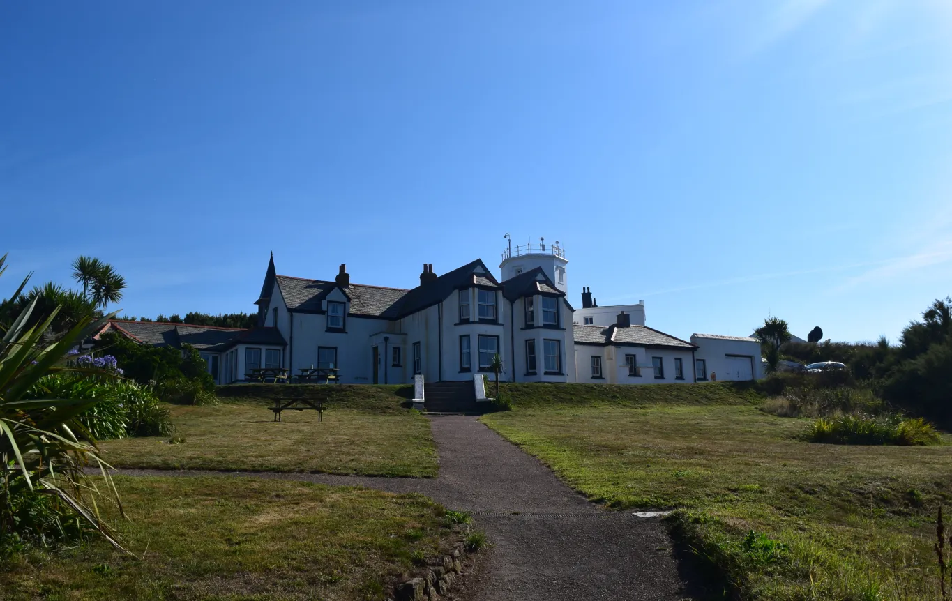
Pic. 46. YHA Lizard Point outside.

Pic. 47 YHA Lizard Point dayroom.

Pic. 48. Night sky seen from the Lizard Point. See a small light glow in the middle of the horizon, just above the seawater. There is Brest, a city, which lies on the opposite side of the English Channel in France, 55 mm.
Summary
At the finish, I would like to tell you, what would I do when I go back to Cornwall again, where would I stay and what trips would I manage.
If I had to choose the accommodation I would select the YHA Lizard Point again, because the location is nice and the place is really secluded, far from the traffic and turmoil. This is a perfect place to take a rest and watch the world go by. Making daily trips could allow you to do good and quite cheap shopping in the closest Helston town. From Helston, only you can reach the Lizard Point by car anyway.
Mixing those 2 trips I would back to Cornwall for a week. I would take 2 or even 3 days off laying on the nearby beaches (Housel Hay Beach, Kynance Cove Beach) and visit Cornwall for the rest days making at least 3 “loops”:
1 – Lizard Point – Tintagel – Port Isaac – Newquay
2 – Lizard Point – Helston – Falmouth – Mevagissey – Eden Project – Cornish Alps
3 – Lizard Point – St.Michael’s Mount – Porthcurno – Land’s End – Cape Cornwall – Batallack village
4 – St. Ives – Bodmin Moor (on the way down home or at the beginning)
5. Tamar Bridge (on the way down home or at the beginning).
The distances across Cornwall are not long. Driving from Lizard Point you can reach the Tintagel Castle after around 2 hours. There are two of the most extreme points in Cornwall within one trip. Remember also, that the sightseeing duration recommended may differ between some places. Eden Project will soak you for at least 3 hours, similar to the Tintagel Castle and St. Michael’s Mount (taking into account, that you will pay the admission and go inside) unlike the Cape Cornwall where basically you can take a few pictures, look around and leave this place after half an hour. It’s up to you. I hope, that my article will help you to manage your own trip to this excellent part of the United Kingdom.
Mariusz Krukar