
6 logistic hints for a beach day with your toddler
Probably you heard a lot of sentences and conclusions from your kids or friends, that if you have a very small baby is hard to take it somewhere. In fact, when your baby is younger, that 1 year, be prepared, that everything touched by your kid will eventually be landed in its mouth. Another thing is the sun. It’s not advisable to expose your small child to direct sun, because the sun can cause sunburns, especially when the skin is faint. They can be painful both for the child as well as their parents too. Having a small toddler we also have many more things to get around with, unlike when you go alone together.
Because I am a geographer, I would like to point out of the 6 pivot logistic things, that each family should consider when planning the beach day with the youngest.
I won’t describe stuff like “apply sun cream, set a beach tent”, etc., because you can find a multitude of tips such as this elsewhere on the web. I would like to focus on the practical stuff, looking at it from the tourist guide’s point of view. I am a young father, who has 10 months daughter. She already visited a few beaches both in the UK and southern Portugal, which explains where this advice comes from.
- CHECK THE WEATHER
This is a trivial thing, about which everyone knows. However, it’s not only weather in a general sense, that I mean. Usually, when we are planning to go to the beach, we are wondering if will it rain or will be sunny and what temperature is going to be. It’s good, but once we have small children, we should take into account also other factors.
Wind – it’s the major weather element, which especially at the seaside can be bigger, than inland. Why the wind is so important then? At the shore, the local wind called sea breeze is cooler throughout the day. When this sea breeze is too strong, then may strongly impact the felt temperature in general. It means, that even, when the forecast is saying i.e. 25 Celcius degrees (which should be fine for a beach day), we can feel cold, especially at the moment, when Sun is gone. It can work also another way around; the wind can cool us when the beach is too hot. Apart from the temperature drop caused by wind, there is another issue, that we should consider. When the wind is too strong it will be harder to set the beach tent. Besides our child won’t take a nap, when its tent is wind-swept. It applies also to the beach screen and umbrella. The strong wind also triggers bigger waves, although they are common everywhere. In my opinion, when the forecasted wind speed is bigger than 15m/s I would think about whether is it worth going. Even if this wind may occur only for a few hours.
Felt temperature – much more important, than normal temperature. This is the temperature, which we will really feel. This temperature is mostly different than the predicted normal temperature. It varies due to a few factors, of which the most important are solar irradiation and wind strength. During a sunny day, under clear-sky conditions, the felt temperature will be usually bigger than predicted. Strong solar irradiation causes also surface irradiation. Being on the beach you can feel it when putting your leg on the shined sand, which is hot. As the day warms, also the surface heats up, influencing our felt temperature, especially when the weather is stable, without any breeze. Regarding wind, as discussed above, it will cool down the felt temperature. Another element, which shapes the felt temperature is the air humidity. When the weather forecast says about big humidity, be prepared for a bigger felt temperature.
Cloudiness – is another major thing to look at. When you are planning a beach day with your small children, cloudy weather will be rather helpful for you. Some sun is desirable throughout the day, although when the sky is completely free of clouds it will be harder for you and your baby. Basically when cloudiness covers the sun from time to time is easier for all of you, because the felt temperature is a bit lower and the beach surface is less hot.
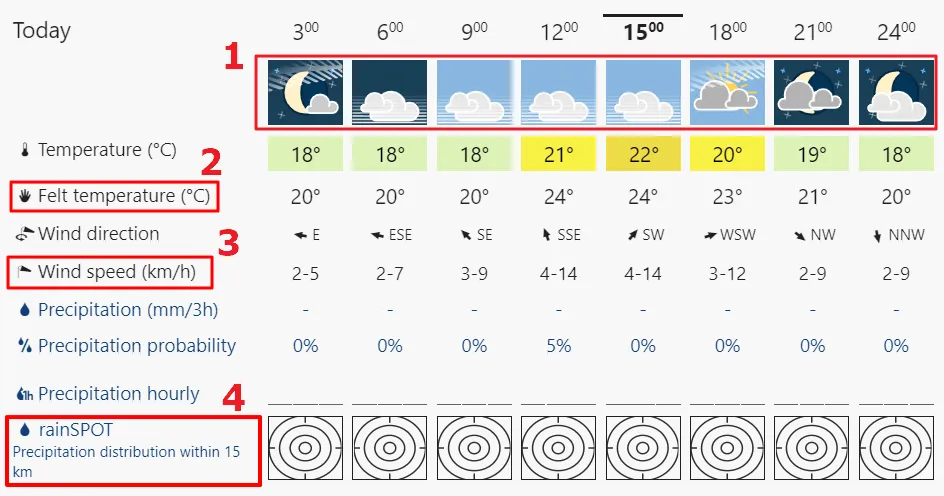
Pic. 1 The weather forecast example and pivot things to look at, when planning the beach day with your child: 1 – cloudiness, 2 – felt temperature, 3 – wind speed, 4 – precipitation in the nearest area.
It looks like I have explained all the major weather factors, that should make your decision about the beach day. The last thing, which I would point out is the precipitation in the nearest area. You will check the possible precipitation for your beach/region for sure, but weather conditions are only likely, not 100%, which means that if the forecast for the adjacent region is worse, then even you can be hit by rain.
Basically checking the weather via Google is not enough. The good weather forecast, which became quite common recently is meteoblue.com. If you wish to see more detailed weather forecasts, please visit all the links, gathered here.

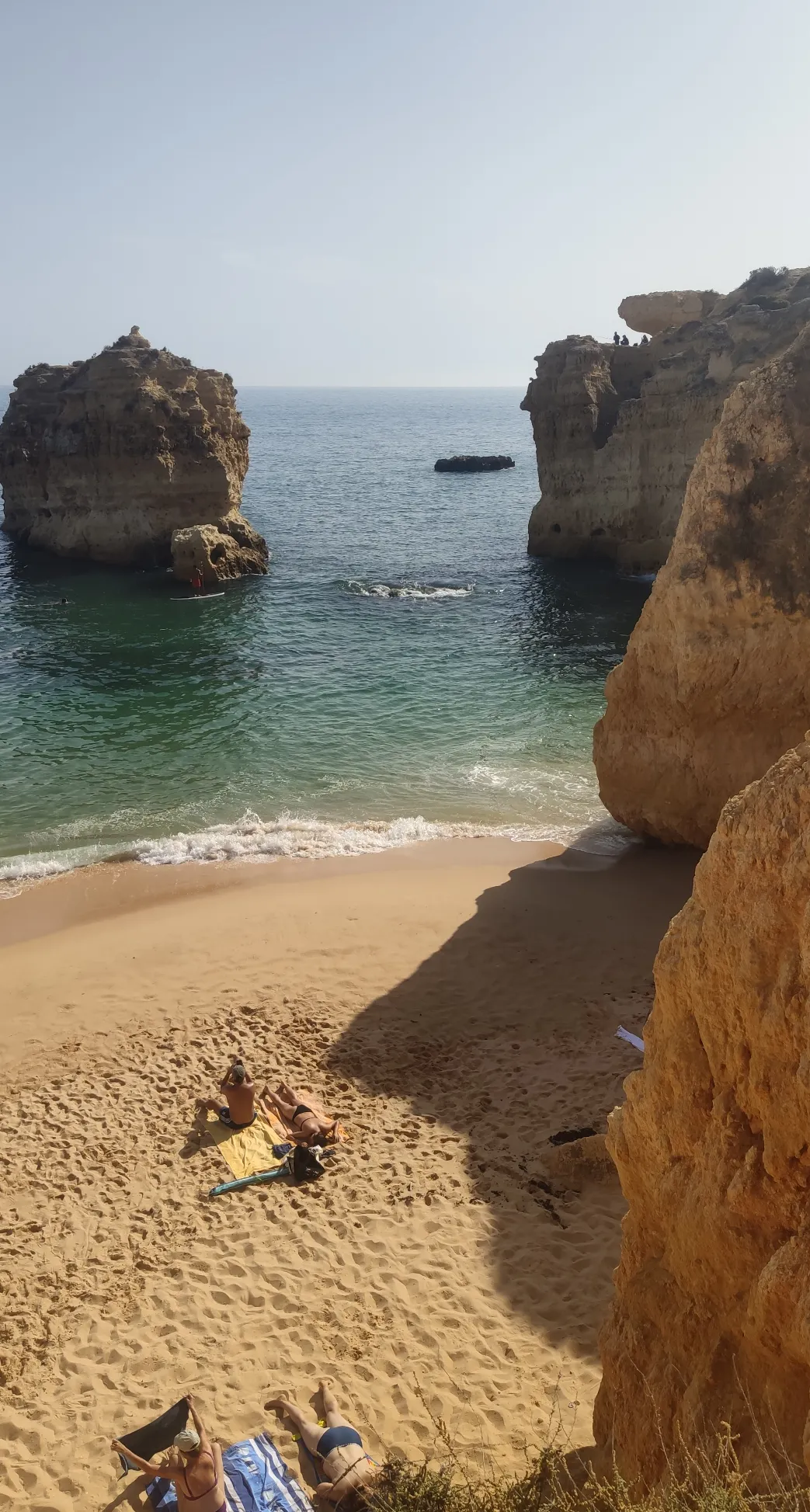
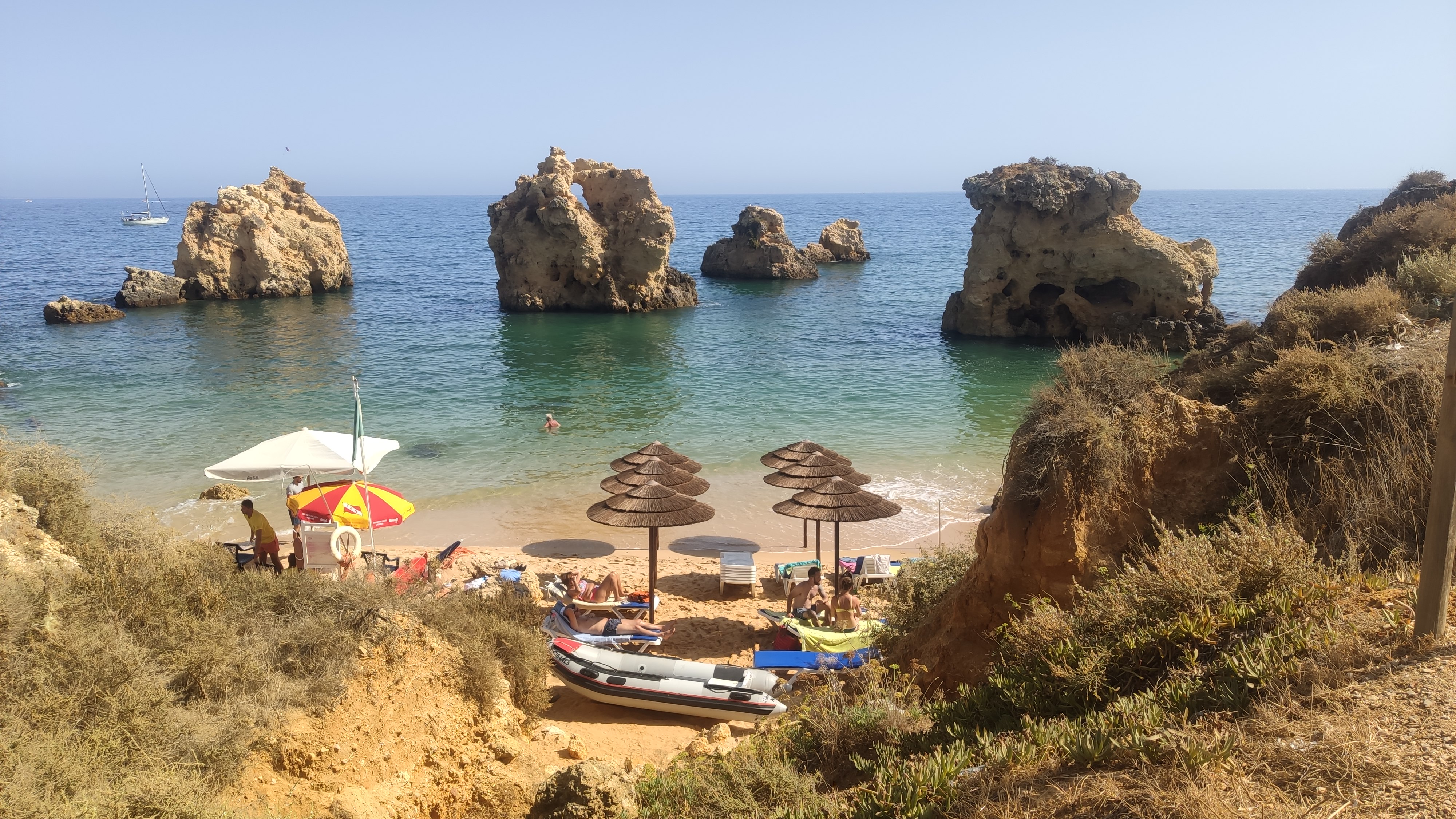
Pic. 2 Praia de Benagil (Algarve, Portugal).
2. SAND, GRIT, OR PEBBLE?
At least for me, the best beach is a sandy beach. You can have a different opinion, which is natural. Every parent must consider what is best for their toddler – sandy beach, gritty or pebbly? Be prepared, that every kind of them your child will try with a mouth when it is younger than 12 months. None of them are safe, because apart from a lot of bacteria, they can strongly affect the oral cavity. In my modest opinion, I would rather see the sand in my children’s mouths much more than grit or pebble. Because grit contains a lot of small and sharp pieces, it may hurt the baby’s oral cavity and finally digestive system, once it hooks down. Pebbles can cause choking, due to their sizes. From the logistical point of view, and is the best for barefoot movement around, so you can chase your child much quicker when it escapes you at some point.
Choosing the right kind of beach we can use pics widely available on the web. This is the best way to gauge, what kind of surface will we have on-site. However, sometimes, there is a lack of bigger-size images or they don’t show our area properly.
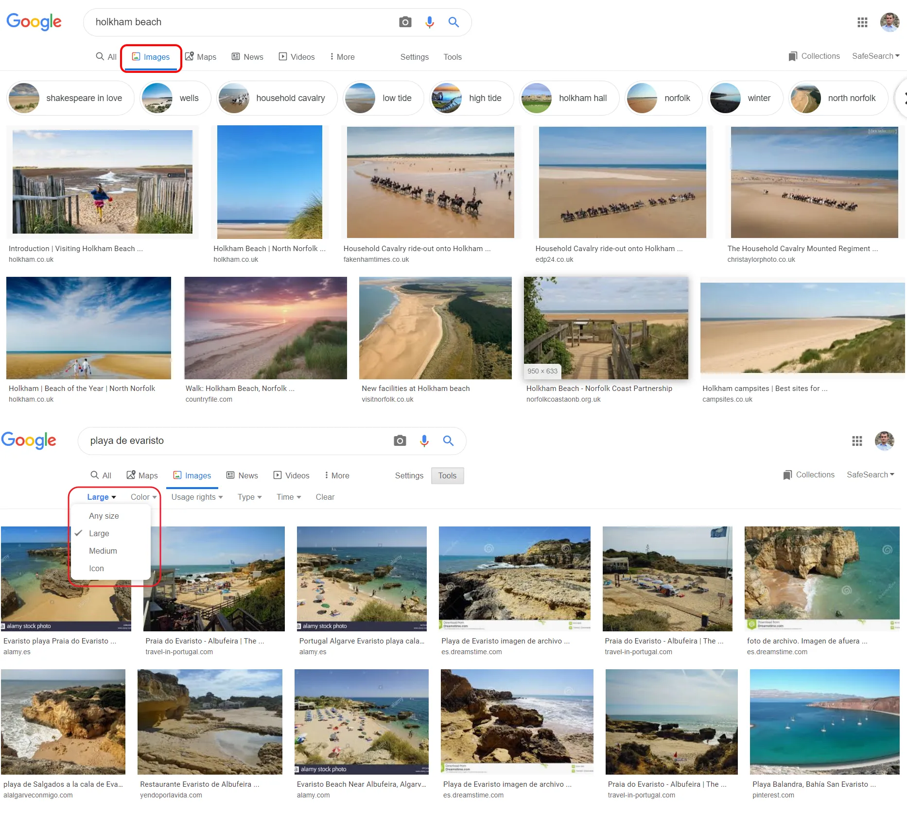
Pic. 3 The quickest way to check what our beach looks like. Go to the Google image search and select possibly the largest size of images (marked red) in order to see as many details as we can.
Another way (although a bit longer) to see our beach in more decent images is digging down through the Flickr.com image repository. After typing the name of your beach (as long as it’s quite common) you will see a multitude of images. Select a random one and download it on your hard drive. As a result, you will see a lot of details unless the image is noisy (Pic. 4).
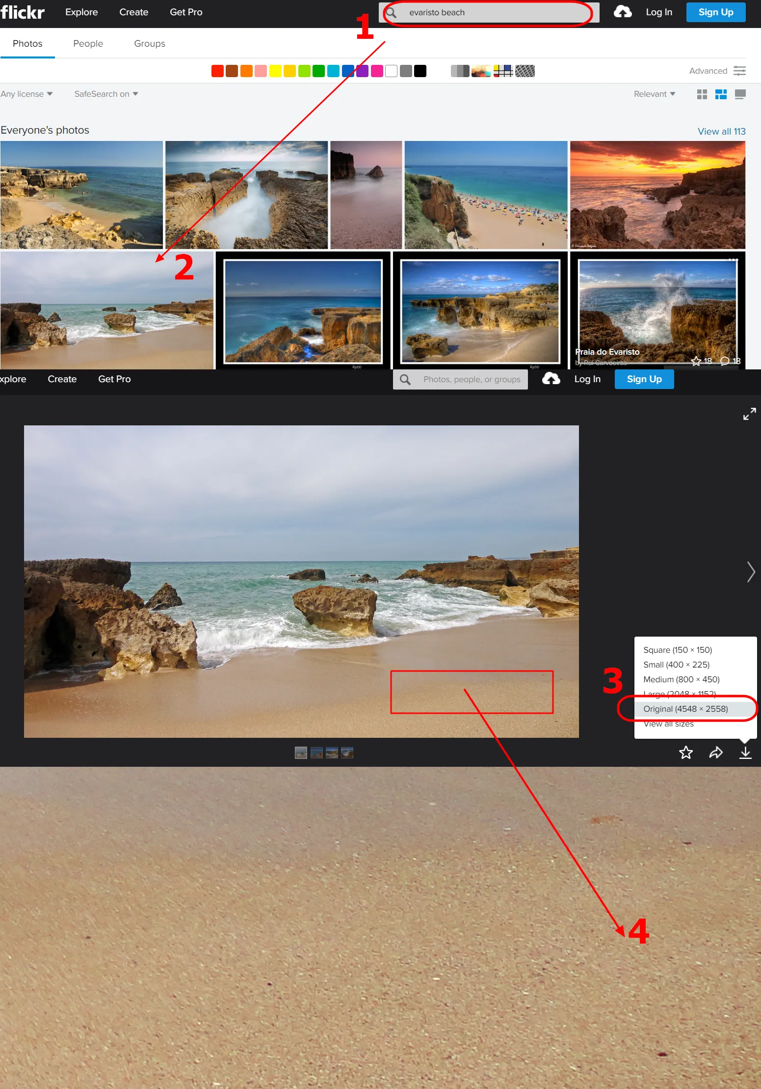
Pic. 4 Checking the beach via Flickr.com image repository, from where you can download one of them and see in full size how it looks: 1 – type the beach name (or place, where are you planning to go to), 2 – select a random image from the photostream, 3 – download full size, 4 – check the details in the actual size.
Even so, usually is hard to distinguish between the sandy and gritty surface. One of the hints can be a type of shore. If we have a lot of rocks around, then our beach won’t be as nice as we are guessing. Sandy beach is usually typical for a flat coast with spits, lagoons, and land gradually falling into the sea. An exception can be also a cliff shore, where land is built by weak sedimentary rocks i.e. clay, mudstone, or fine-grained sandstone. However, it’s also not a rule.
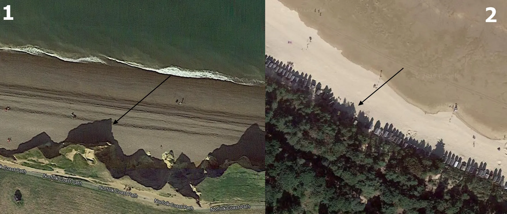
If you want to check your beach very quickly, then you can use Google satellite imagery. You won’t be able to distinguish sand from grit, but at least you will see where the beach is sandy and where it is shingle. You will recognize it not by color, but by other features. For example, the plain colour, as well as small ripplemarks (parallel wavelets) seen on the surface can indicate the sand. In turn, when you will see some grains on the satellite imagery, then you must be prepared for a shingle or pebbly beach (Pic. 5).
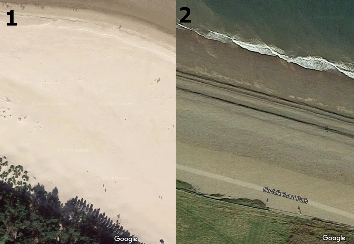
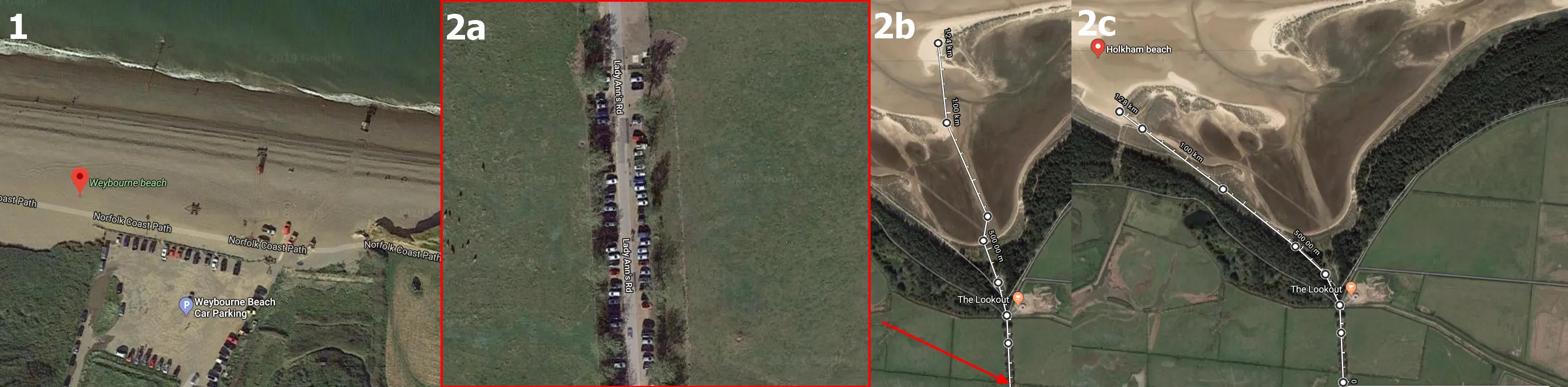
Pic. 5 Satellite imagery comparison between sandy and pebbly beaches: 1 – sandy beach with plain colour and some small wavelets (Holkham Beach), 2 – shingle beach with a grainy surface as seen from space (Weybourne Beach).
Another feature of sandy beaches is for instance footprints or wheel marks, not as such easily visible on the pebbly beaches.
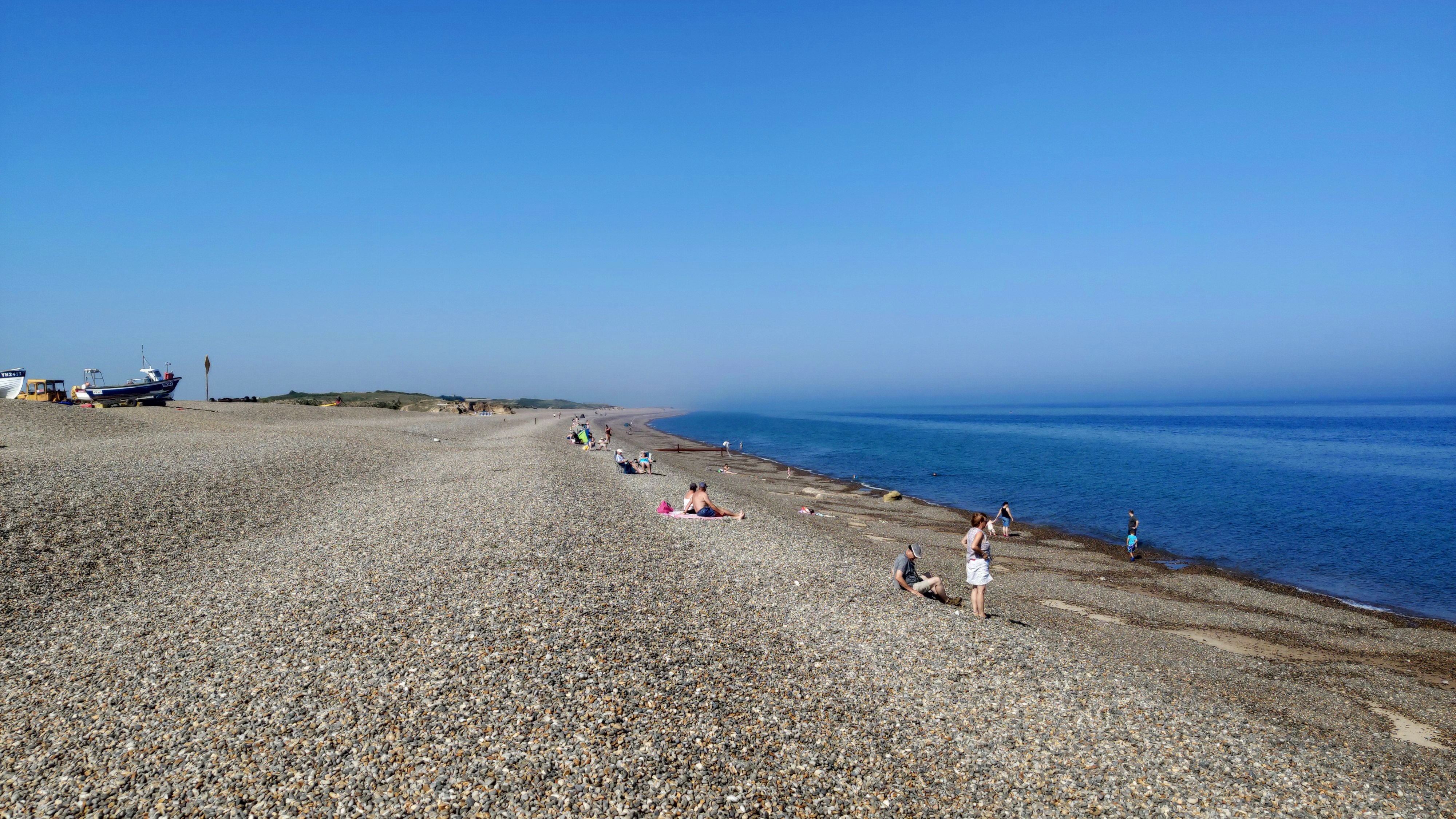
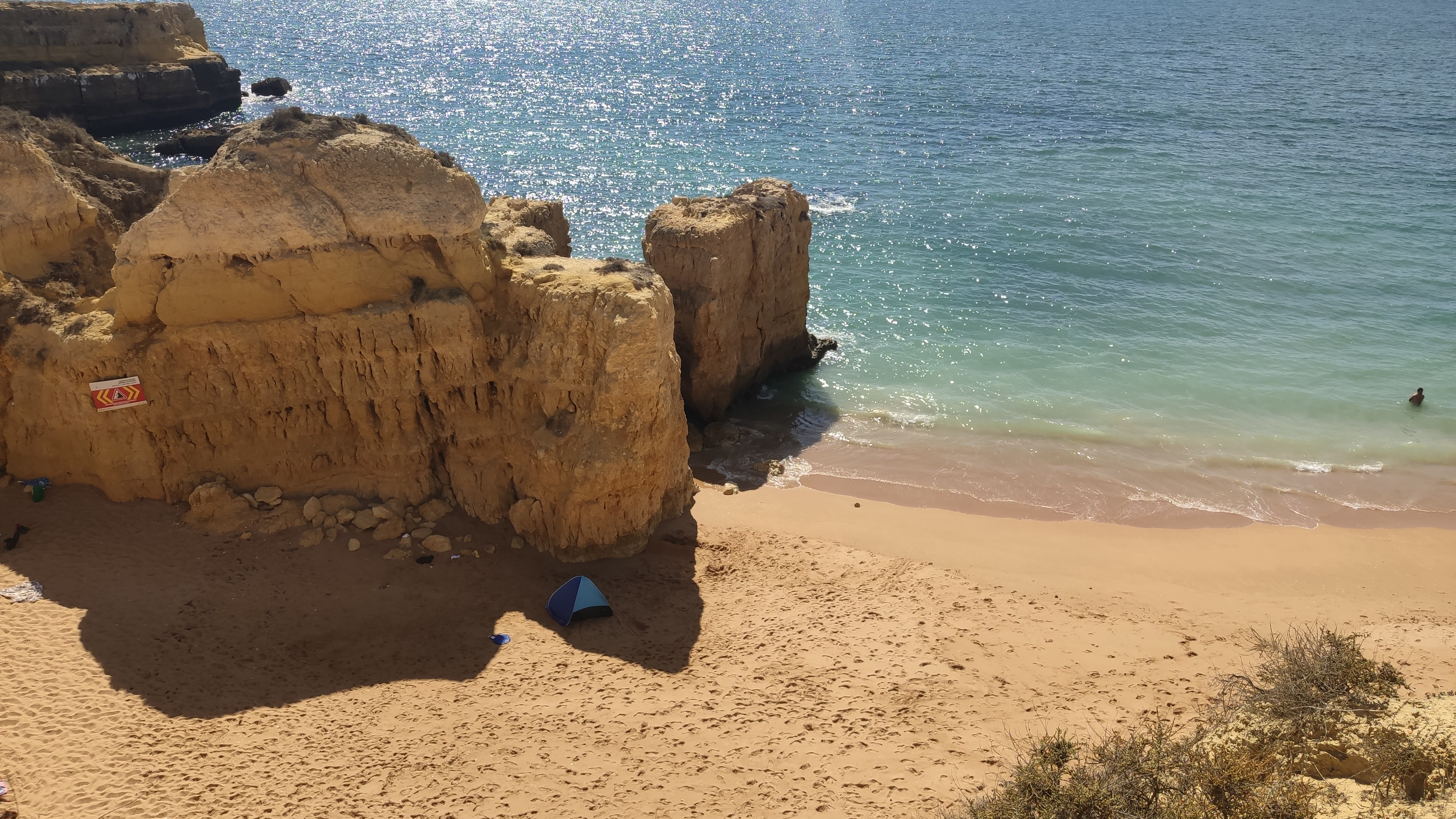
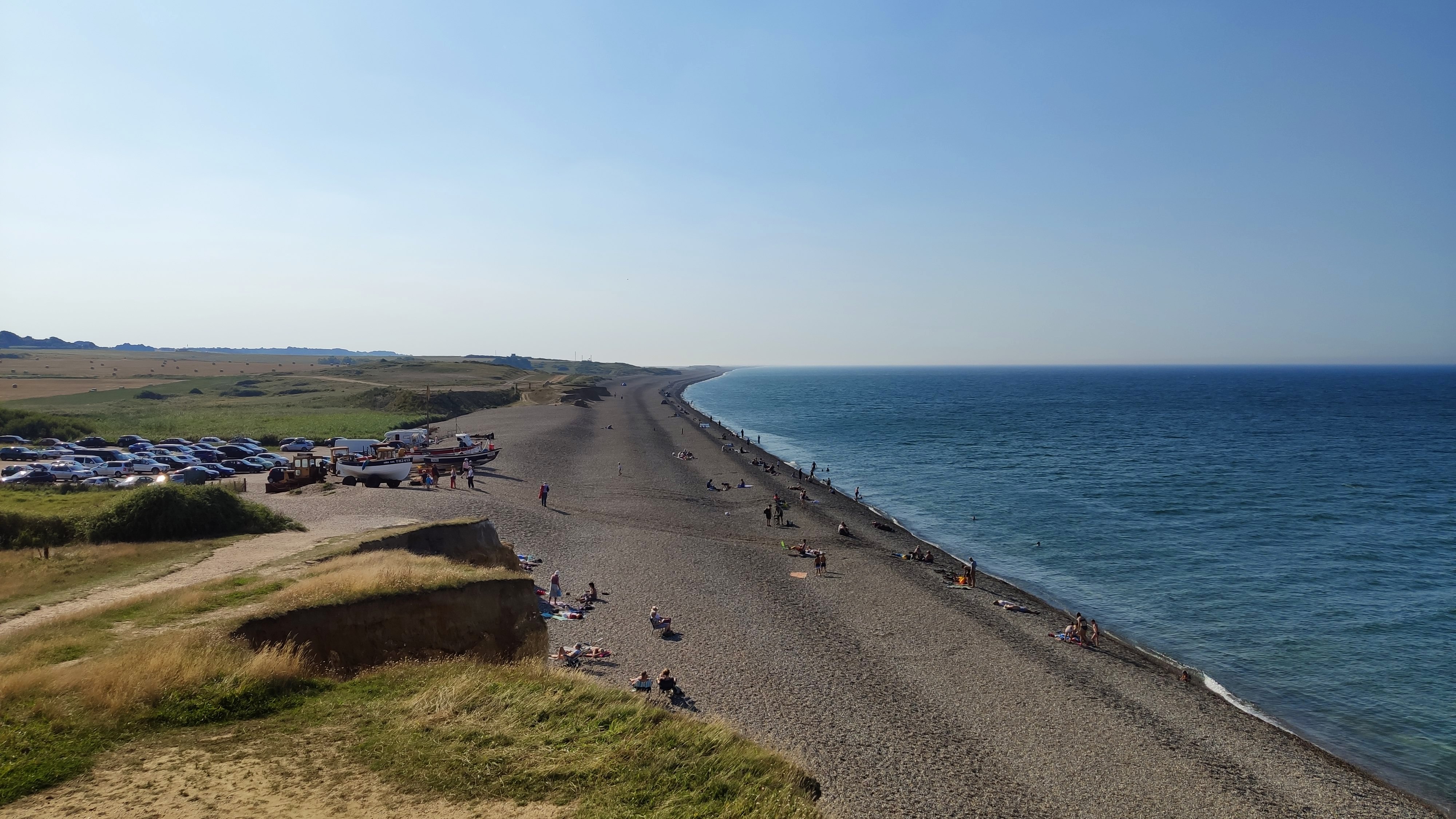
Pic. 6 Pebbly Weybourne Beach (Norfolk, UK).
3. FIND A SHADOW!
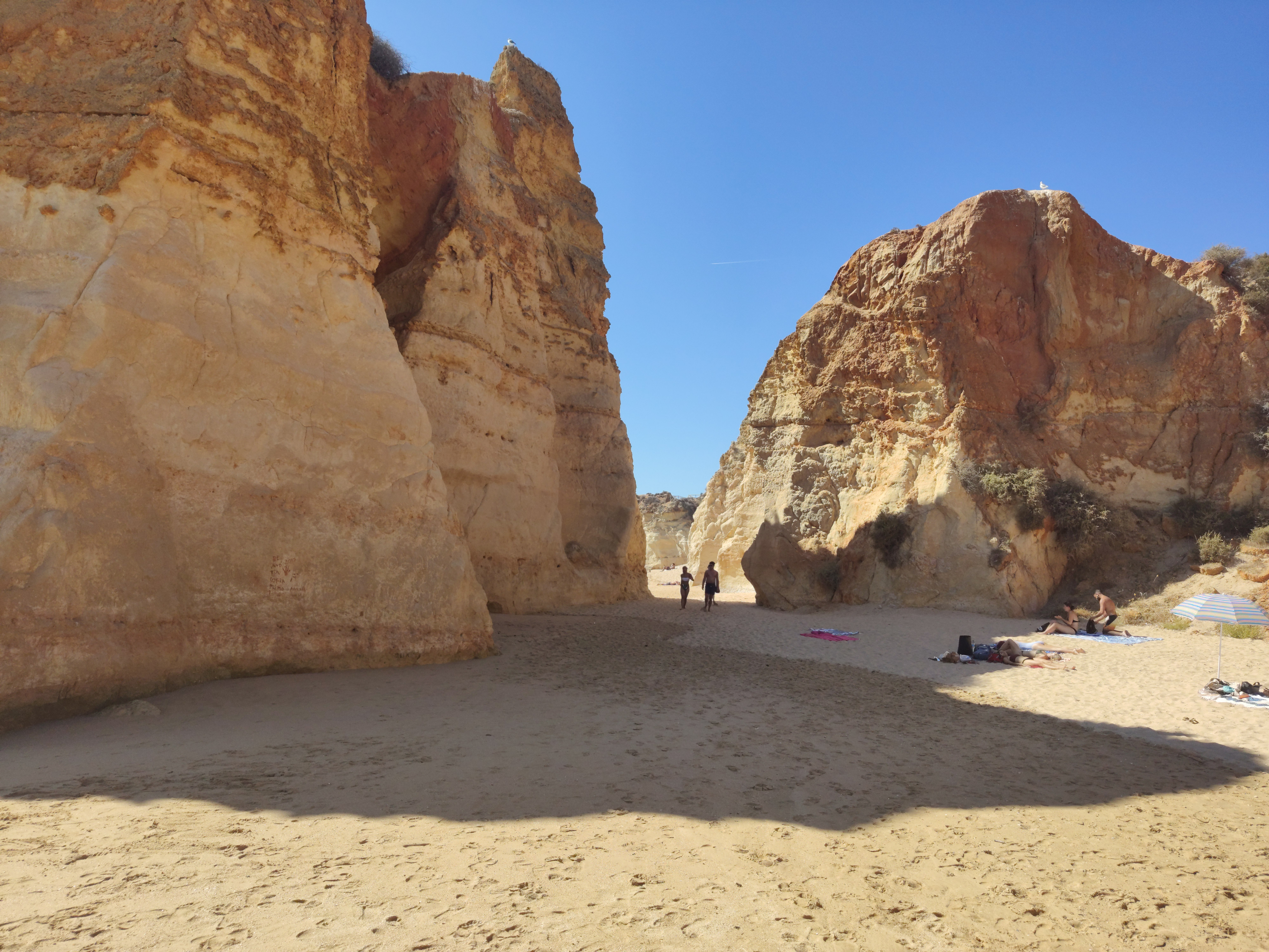
Much more important, than kind of the beach surface is the availability of the places, free of solar irradiance, at least for a few hours. Basically during a hot, sunny day, we can prevent our toddlers by setting up a beach tent or an umbrella, however, the shadow cast by these objects won’t be sufficient I believe. We will constantly look after our baby, eager to play outside. Having at least a while, when the Sun is covered i.e. by a cliff or tree can be such a relief for us. The worst and shadowless beaches are typical for flat coasts, where the treeline is backed about several meters inside the land, giving usually the space for some shrubs, high grasses, and finally sand sedges in the closest vicinity of the open sand. Better locations feature cliff shores, where there is some likelihood, that the Sun disappears for some time unless the landfall is not on the south. Sometimes even under the cliffs, we can have a lot of suns, which depends on the beach orientation and the cliff line diversification (Pic. 7).

Pic. 7 The example of cliff beaches without the shadow during the hottest period of the day, as both of them, are facing south-west or west direction. The cliff shore is not diversified enough: 1 – Praia de Falesia near Albufeira; 2 – Praia de Arrifana near Aljezur, Algarve region, Portugal.
The worst-case scenario applies to the beaches oriented between the southern and western directions, where the strongest solar radiation (afternoon time) takes place day by day.
When your cliff shore is more diversified, featuring some nooks, cavities, or other corrosive elements, then it is possible, that some shaded areas are available throughout the day (Pic. 8).
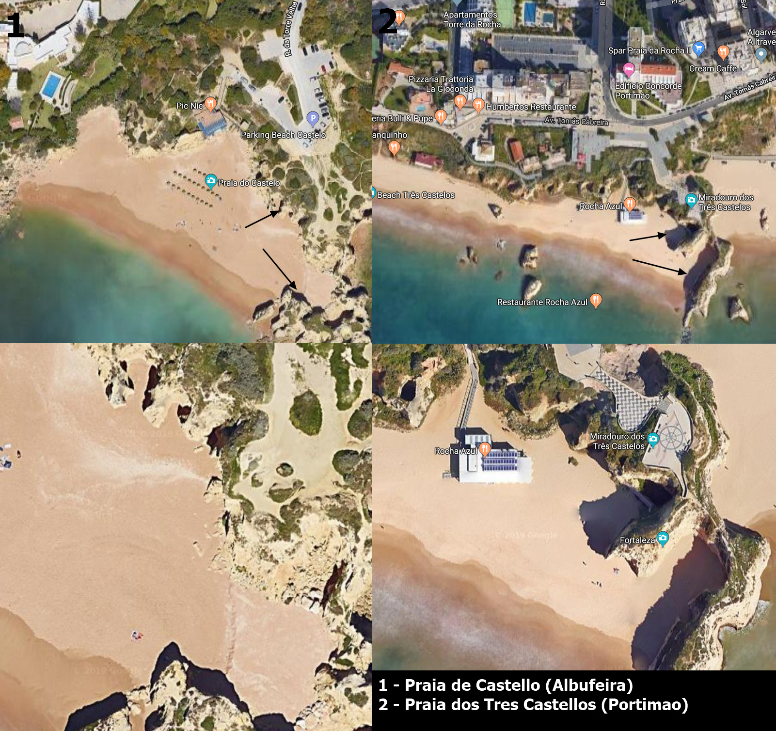
Pic. 8 Some of the Algarve beaches (southern Portugal) feature shadowed areas. Click to enlarge.
On the other hand, the corrosive features near the beach can cast their own shadows at least for a few hours during the day.
You can check roughly when some parts of the beach are shaded, using the Sun Locator Lite App (Pic. 11). Setting your location and shifting the view into satellite imagery, you will have the same view as Google imagery with the dummy sundial provided. Sweep right and left on the bottom as you will spot how the shadows move during the day.
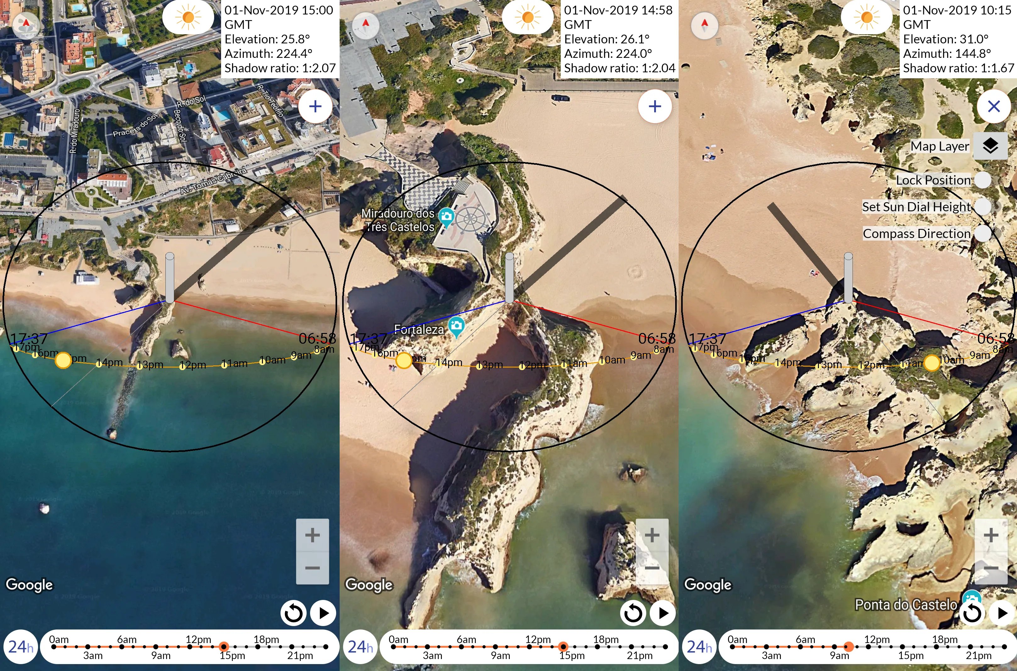
Pic. 9 Sundial app showing the shadow circumstances for some of Algarve beaches: two from left – Portimao, Praia dos Tres Castellos; right – Praia do Castelo. Click to enlarge.
Pic. 10 Praia dos Tres Castellos in Portimao – some shaded areas behind the rocky protrusions.
Pic. 11 Shaded areas on Praia de Sao Rafael in Albufeira in the afternoon time.
Pic. 12 Shaded parts of the Praia do Castello in Albufeira at the midday time hours.
A completely different situation occurs when our seaside is in a northward direction. In this event under the Sun passing through the southern sky, the objects will cast their shadows towards the north, possibly shedding the beach from the solar rays. That situation happens i.e. in Norfolk (United Kingdom), where the shore takes the stretch from west to east (Pic. 12).
Pic. 13 An example of shaded shores in the UK – Norfolk coast: 1 – Weybourne Beach (near Sheringham); 2 – Wells-next-the-Sea beach. Click to enlarge.
As a result, you don’t really need to worry about the shadowed area. An exception can occur mainly during the early summer when the Sun can be much higher than at the time, from which the Google imagery comes from. By the way, you can check the month, when these images were taken, by looking on the bottom ribbon of the Google satellite imagery toolbar in Google Earth, if you want.

Pic. 14 Shaded parts of Weybourne Beach at the midday time hours (Norfolk, UK).
Pic. 15 View on the North Sea from the shaded West Runton Beach near Cromer (Norfolk, UK).
In the majority of cases, the satellite images come from around-noon time, when the land illumination is the best. You can recognize it by looking at the shadows, which almost always indicate the opposite direction to the Sun.
4. HOW FAR IS THE CAR PARK?
Another very important thing, that we must sort out before we go to the beach is the car park location. Having a small family member with us is really tough carrying it for a long distance. You won’t be happy if you find, that from the car park to the beach is about 1km, trust me! The best option to check is definitely the Google satellite imagery again, which brings you a valuable answer (Pic. 16).
Pic. 16 The distance from the car park to the beach: 1 – Weybourne beach (car park next to), 2abc – Holkham beach, where: 2a – car park along the lane; 2b,2c – distance from the car park to the beach (about 1200m). Click to enlarge.
You will find the car park by a group of cars captured by Google (Pic. 16,2a). Next, I would advise you to use the Google measurement tool in order to gauge the distance to walk.
The presence of a car park means basically two things. The first one is, that you are sure, that you can get there by car. It’s trivial, but trust me, sometimes your navigation or even Google Hybrid map shows some road, which is not accessible by car at all. Setting the destination at the end of that road you put yourself at risk of precious time-wasting (and putting your family in a bad mood). The second one means, that when the car park is located close to the beach, then you may expect a big crowd at the peak of the season. In this case, you can walk a bit further from the car park alongside the beach in order to avoid it.
Pic. 17 Weybourne Beach onlook with the car part immediately next to (Norfolk, UK).
5. WHAT IS ACCESS TO THE BEACH?
Having the car park close to the beach doesn’t mean, that our further way will be easy. Sometimes, especially at the cliff shores, we can be obligated to tackle a difficult descending (and in the end ascending) way. A good example is the Algarve region in Portugal with a beautiful rocky seaside. There is no point in considering a typical flat shore because there is no need to climb.
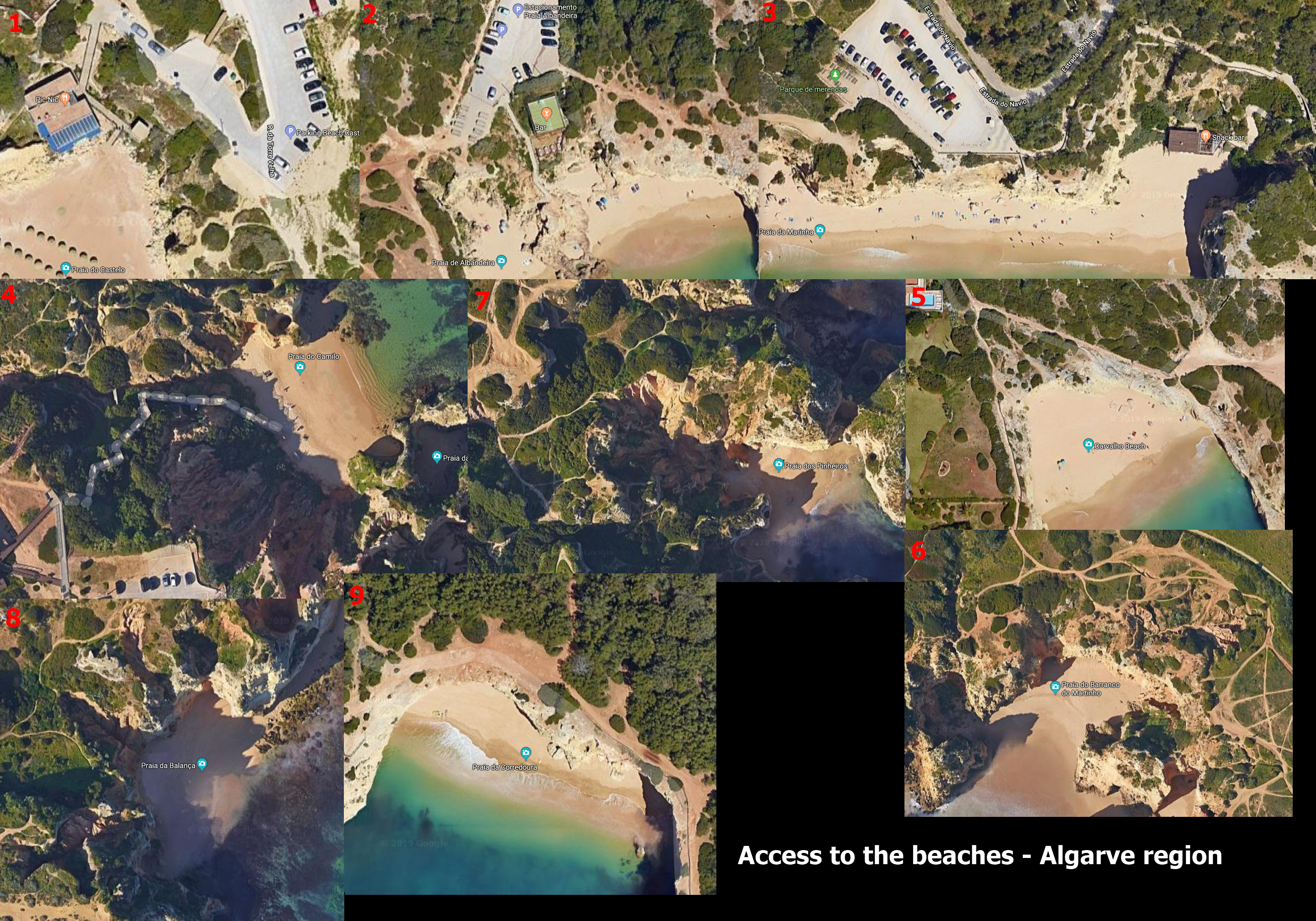
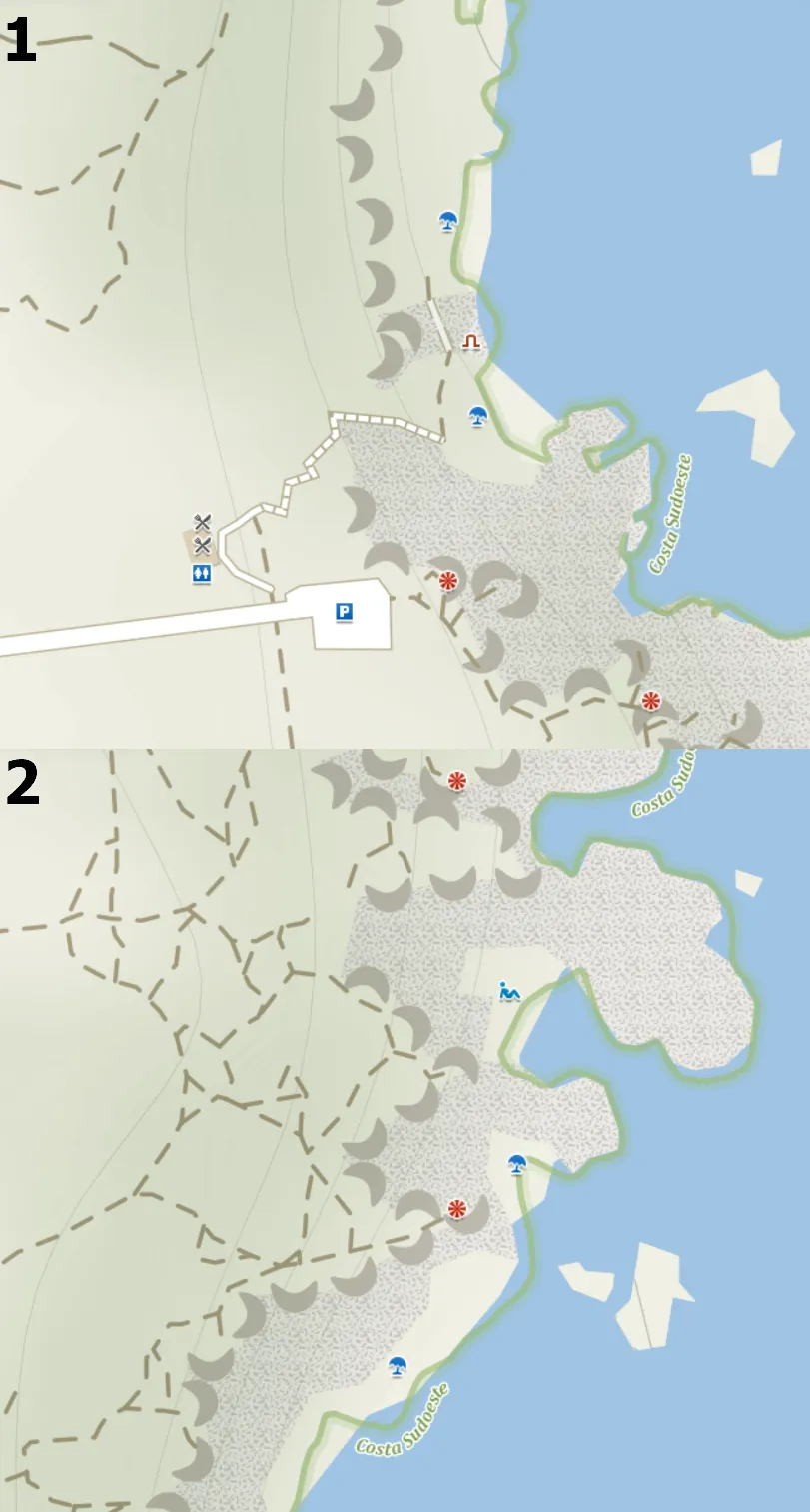
Pic. 18 Access to the beaches in the Algarve region, where: 1-3 The best access with paved road or path from the nearest car park or paved road combined with the stairs (1 – Praia do Castello, 2 – Praia de Albandeira, 3 – Praia de Marinha); 4 – The stairs (Praia de Camilo); 5-6 – Steep unpaved footpath (5 – Praia de Calvarho, 6 – Praia de Barranco do Martinho); 7 Tenuous access (Praia dos Pinheiros); 8-9 No access from the top (8 – Praia da Balanca, 9 – Praia da Corredoura). Click to enlarge.
According to my conclusions, based on the Algarve’s rocky shores I would divide the beach access into 5 major types (Pic. 18):
– easy access – with a paved road or path leading straight from the car park to the beach, where you can move your baby in a pushchair easily. Alternatively, there are gentle stairs instead of the path or the path is combined with the steps (i.e. Praia de Marinha).
– moderate access – the steps continue from the very top of the cliff to the beach with ten meters of total length (i.e. Praia de Camilo). No way for pushchairs. Only swaddlings.
– hard access – very steep footpath, that requires a difficult descent and hard climbing. Not recommended for parents with their toddlers,
– tenuous access – there is no proof of access seen on the satellite imagery. If the access exists, is not recommended, or is not used so often,
– no access – you can reach this beach from the sea only unless you want to see it from the top only.
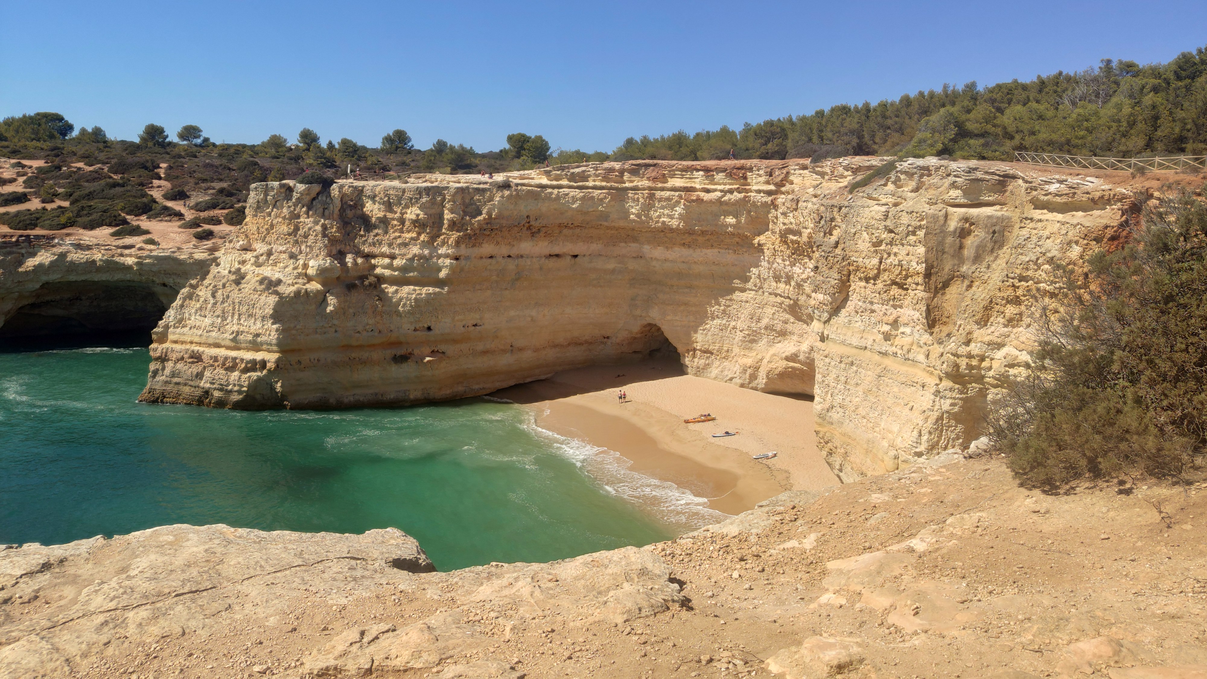
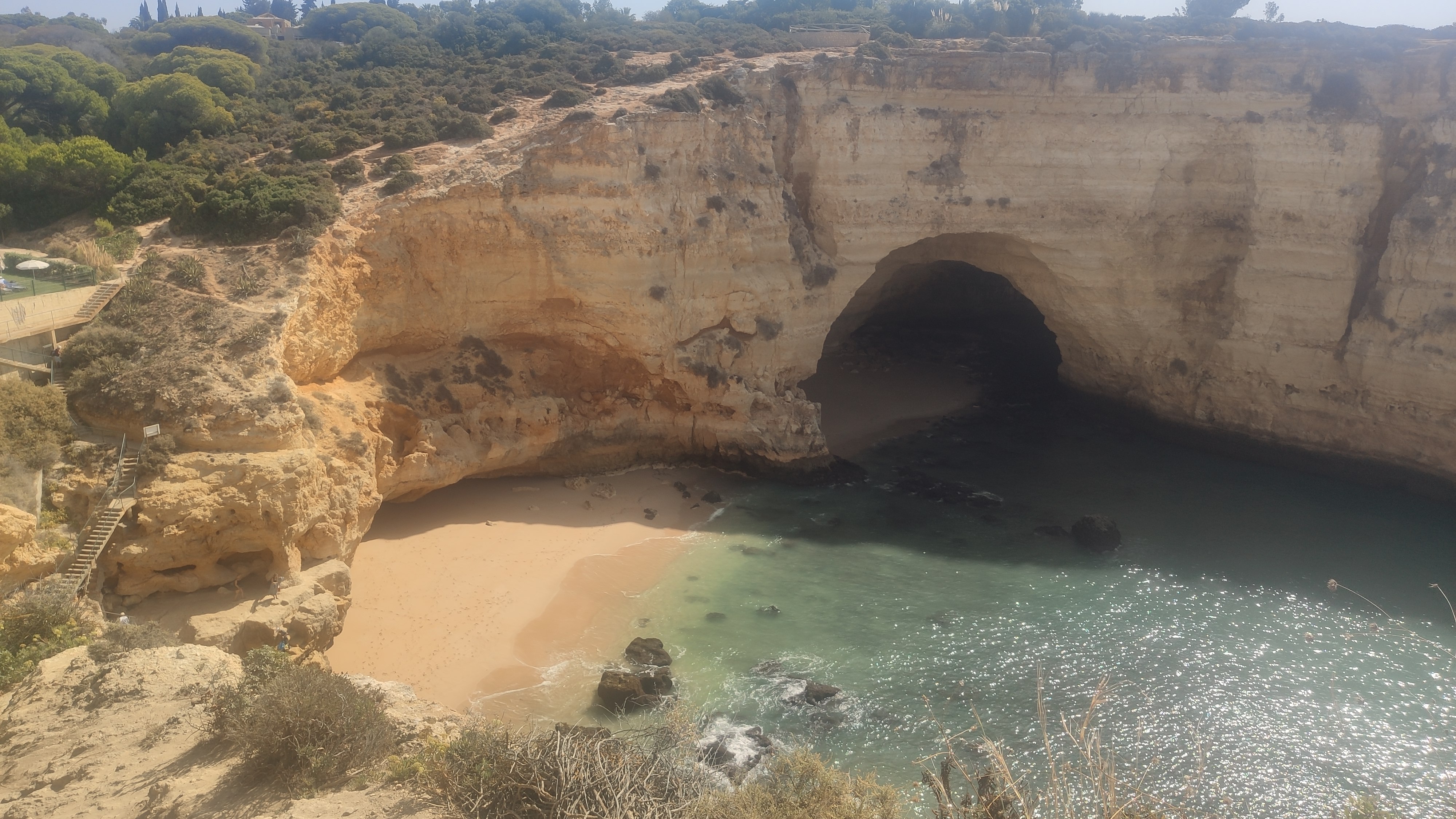
Pic. 19 Praia de Corredoura near Benagil – an example of the beach with access from the sea only.
If you have a child I would recommend you only the first two types of access, that are safe enough. In other cases, you may put yourself and especially your baby into trouble due to for instance the slippery or fall from heights risk.
Don’t trust footpaths, as you see on your satellite imagery! Especially if you want to go there with the pram. They can be hard even for a simple walk (Pic. 20).
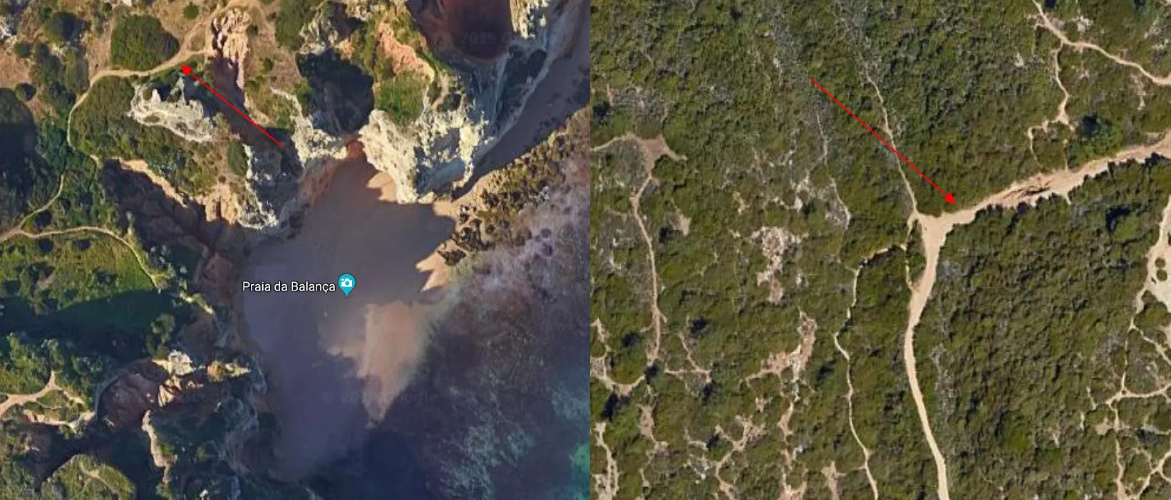
Pic. 20 Typical ground paths alongside the shore in the Algarve region (shown red). None of them are suitable for pushchairs because of roots, holes, stones, and other bumpy features. Left: Praia de Balanca near Lagos; right – west from Praia de Marinha, near the Arco Naturalis. Click to enlarge.
Usually, these paths lead across a quite big terrain declivity, where there are a lot of bumpy features, difficult to get around (Pic. 21).

Pic. 21 The footpath leading near the Arco Natural beach west of Praia de Marinha (Algarve, Portugal).
Looking at the aforementioned photo, you know, that it’s good to avoid the paths, which appear to look unpaved on the satellite imagery. Just in case, you can also use your navigation app. For example, Mapy.cz or Maps.me should tell you a bit about the access (Pic. 22, 23).
Pic. 22 The shoreline is shown in the Mapy.cz “Outdoor” layer: 1 – Prai do Camilo; 2 – Praia dos Pinheiros (Lagos area, Algarve, Portugal).

Pic. 23 The access to the beach can be checked by the Maps.me app: 1 – Praia de Camilo (Lagos); 2 – Praia de Carvoreiro (Carvoreiro); 3 – Praia de Sao Rafael (Albufeira); 4 – Praia do Castelo (Albufeira); 5 – Praia da Balbina (Albufeira); 6 – Praia de Manuel Lourenco (Guia), Algarve, Portugal.
Pic. 24 Praia de Vale Covo near Algar Seco with access by the stairs (on the left) (Algarve, Portugal).
6. CHECK THE TIDE TIMES
The last important problem, which I would like to raise in this article refers to the tides. It’s commonly known, that tides are caused by gravity forces exerted by Moon, Sun, and rotating Earth. As a consequence every 12h26m in the exact location, the process repeats. In practice, it means, that the sea-level changes throughout our stay on the beach for a few hours. It doesn’t really apply to the Mediterranean types of seas, where the tide amplitude is much smoother, and sometimes even thought to be spotted likewise on the Baltic Sea. In other cases, these amplitudes are much bigger, although they vary a lot (Pic. 25).
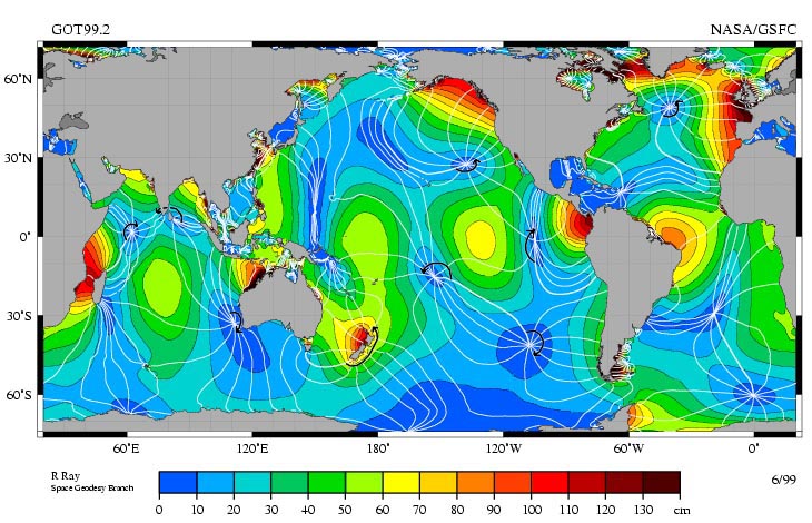
Pic. 25 Tide amplitudes worldwide (Wikimedia.org).
The tide amplitudes and also the time are driven by the shape and local bathymetry of the ocean. Looking at the map above you can spot, that the lowest tidal range is typical not only for the Mediterranean type of sea but also for wide-opened ocean surfaces. The point is, that the tide waves can transverse the ocean without any obstacles. Moreover, their speed is much higher, than when entering the shallow shelf area. The tidal waves, whose count is sometimes even 1000km in length are also interrupted by land masses. Both a shallow bathymetry and a closer distance to the land trigger the interference of these tidal waves, which lose their uniform direction too. As a result, the initial speed of the tidal wave decreases a lot from about 200ms−1 down to 20ms−1. The land presence also causes different timing for the tidal resonance. The hours, when the tide is high and low usually vary across the coastline. The biggest tidal resonance occurs in funnel-shaped bays like the Bristol Channel or the Bay of Fundy. This is because the average independent duration for the wave to travel around the basin is the closest to the solar & lunar gravity force. In general, when the shelf area is around a quarter wavelength wide, the effect is most dramatic. In this case, the incident tidal wave is strengthened by reflections between the coast and the shelf edge, resulting in a much higher tide in the consequence. This is why for example the Gulf of Bothnia has a big tidal range, because of the vast shelf area and quite close distance to the landmasses.
This stuff is to be developed by myself in the future because there is no sufficient explanation on the web. I believe, that the information above will be enough for you. Having in mind, that the tidal range in our destination holiday is big or at least moderate, we can check the local tide circumstances by the “Tide Times” Android app (Pic. 26).
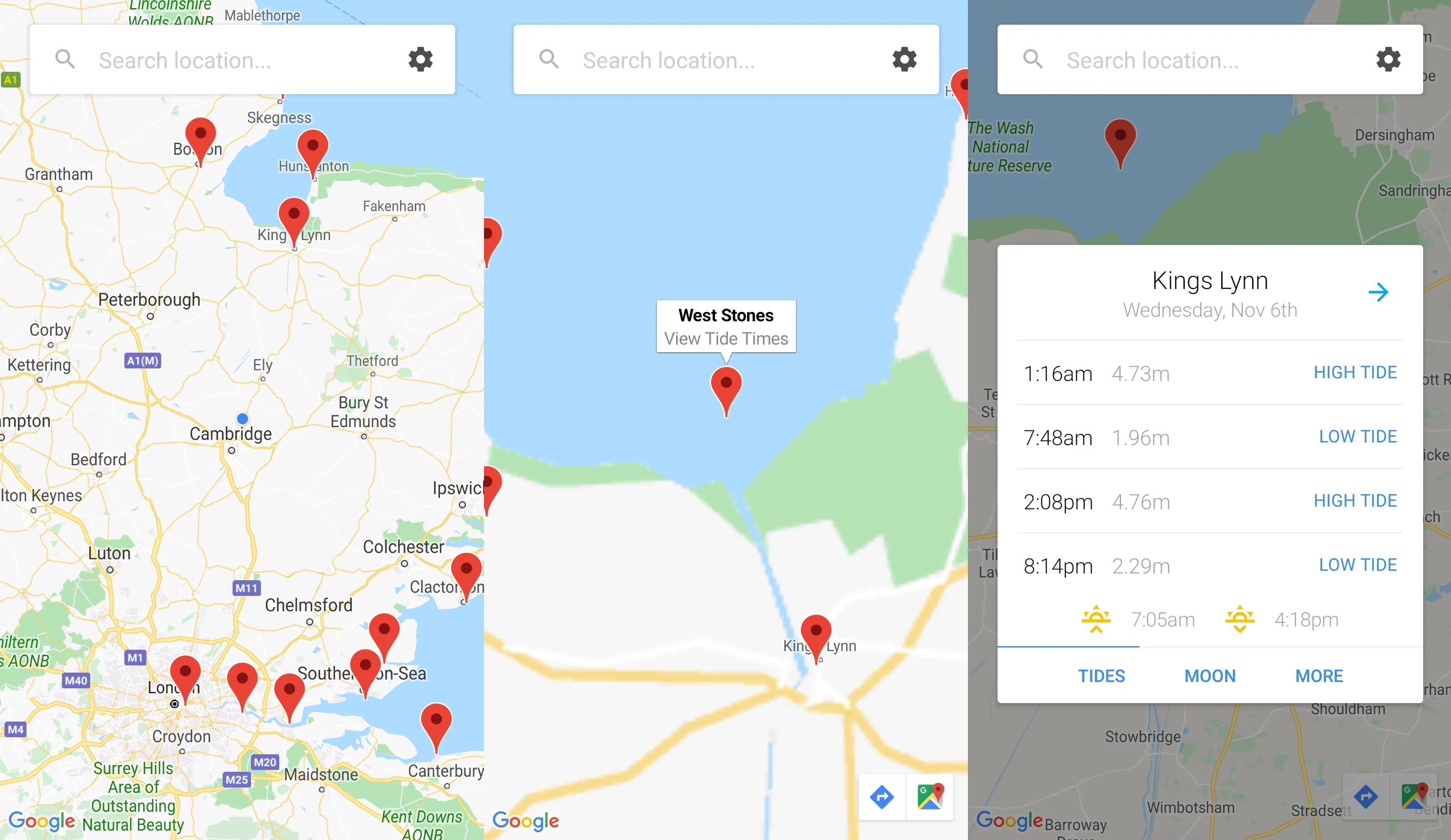
Pic. 26 Tide Times Android app in use – checking tide for random locations in the UK.
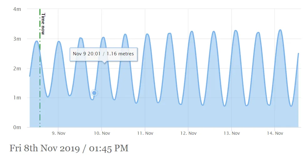
This is I believe the fastest way to check the local circumstances of the tide. You can also check on the web like here or here.
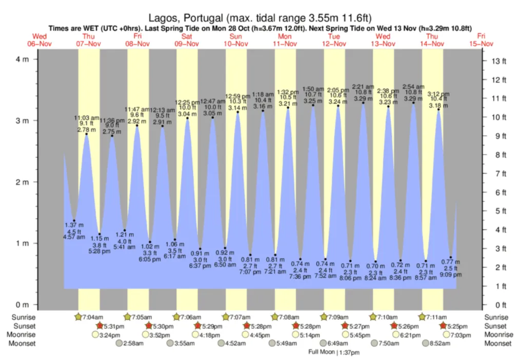
Pic. 27 Tidal charts for Lagos in Portugal (Tide-forecast.com).
Pic. 28 Tidal chart for Portimao in Portugal (Tidetime.org).
Moreover, you will find for sure local tide forecast services tailored for specified countries like the UK.
Why the tide times are so important? Imagine, that you are going to the beach on the flat coast, where the tidal range is big. What happens, during the low tide? The sea retreats even a few kilometers. Instead of turquoise water, you will see mud or wet sand on the horizon.
You can try to check the satellite imagery and see what it looks like, but bear in mind, that pictures won’t tell you a lot, as they show only the random moment (Pic. 29).
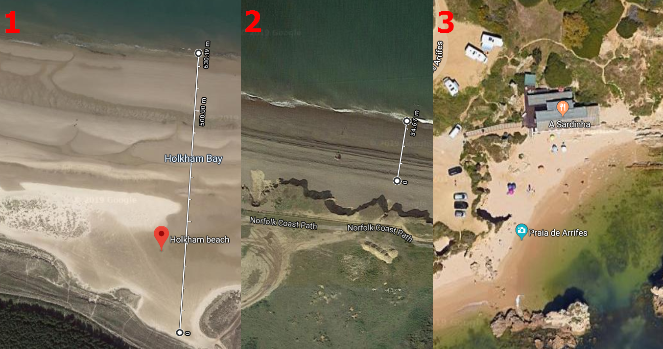
Pic. 29 An attempt to gauge the tide impact on the beach: 1 – Holkham Beach (Norfolk, UK), 2 – Weybourne Beach (Norfolk, UK), 3 – Praia de Arrifas (Algarve, Portugal).
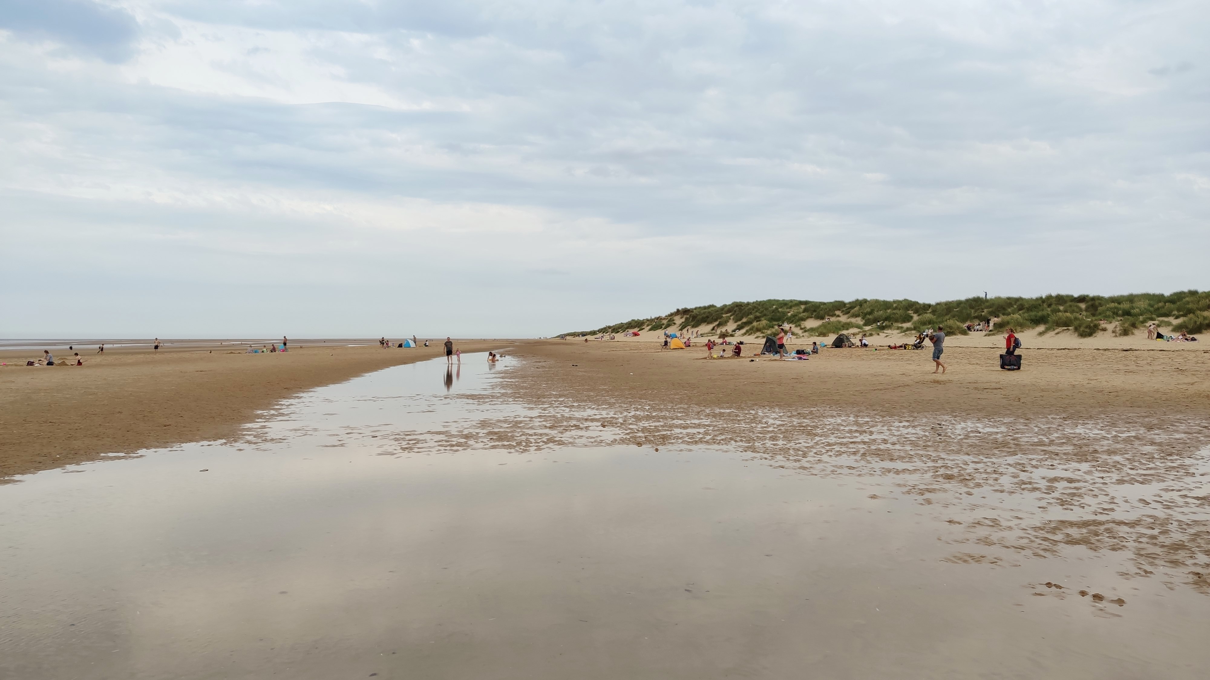
Pic. 30 Holkham Beach during the low tide (Norfolk, UK).
So in turn, the best way is to be prepared for proper beach time and avoid the too-high or too-low tide. Whereas the low tide can take the blue sea out of us, too high tide can strongly reduce the beach capacity. You can guess the maximum level of the tide, looking on the wet sand, before you settle in at some cozy place. However, it’s still not the rule, because the tidal range changes every day as the Sun & Moon configuration changes.
Pic. 31 Praia de Arrifes in Albufeira during the high tide (Algarve, Portugal).
7. CONCLUSIONS
I have shown you major things, which you should take into account when planning a beach day with your baby. This advice can be applied in a general sense, because some circumstances may differ in terms of the situation. I hope, that this article will help you to plan the day at the seaside with your baby. Having this knowledge you will be able to plan as best beach day possible. However apart from the problems, covered in this text, refer also to the other practical stuff like preparation, packing, etc. Make also sure, that your journey is not exhausting for your baby, otherwise, your family won’t be happy, and as a result you either.
Mariusz Krukar
Links:
- https://rainydaymum.co.uk/10-tips-to-toddling-to-the-beach/
- https://themamanotes.com/tips-for-taking-your-toddler-to-the-beach-what-we-packed/
- https://www.wikihow.com/Enjoy-the-Beach-with-Your-Toddlers
- https://musthavemom.com/7-tips-enjoy-beach-toddler/
- https://www.mamacheaps.com/15-must-pack-items-for-taking-a-toddler-to-the-beach/
- https://www.babycantravel.com/beach-essentials-toddlers/
- https://www.labnol.org/internet/find-date-of-satellite-images/2964/
- Ocean tides
- Tides – FAQ
- https://www.tide-forecast.com/
- https://www.tidetime.org/
- https://www.tidetimes.org.uk/
Wiki:
Forums:
Your article is a prime example of excellent writing and thorough research. Well done!
Thanks a lot! It motivates me for further work!