The costless way to geocoding addresses in Excel – part 2, via Bing Maps API

Bing geocoding addresses in excel

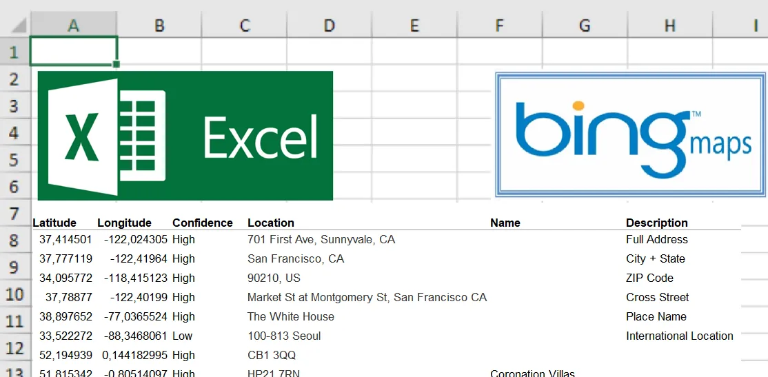
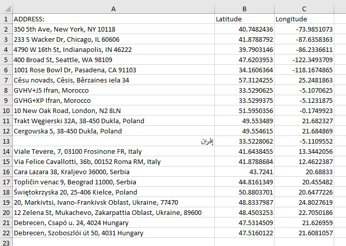
It’s been a while since the previous part of this article when I showed you the way of geocoding the addresses via Google Sheets.  Here you will get the knowledge of geocoding straight from the Excel sheet, without launching external platforms. A front of your eyes you have another two options. These ways were mentioned … Read more

Good solution to georeferencing the AutoCAD DWG drawing in QGIS 3x

Georeference DWG files in QGIS

Today I would like to demonstrate how to georeference the AutoCad .dwg file in QGIS. The .dwg extension keeps layers, colours, line thickness etc. in other words all information included in the drawing file. This is the biggest advantage of drawing files over another AutoCad extension – the .dxf. This format, on the other hand, … Read more

Digitizing administrative maps in Google Earth

Google Earth digitizing maps

The digitizing process is needed when we want to transform our map into vector data. This process is aimed at tracing the map features, which later appear as coordinates in either point, line, or polygon format. Digitizing is essential in the case where our data cannot be instantly integrated with the other GIS data. In … Read more

How to get the floorplans from the MagicPlan app for free?

Magicplan floorplan

The Magicplan is an Android application, by which we can quickly draw the floorplan of any building i.e. camera scanning or corner defining. The spectrum of options looks wide, even in the free bundle because we can add some internal objects and furniture. This is the stuff, which is mostly needed for common work projects. … Read more

Upload vector layers to Windy.com in order to check the weather for your trip

KML layer at Windy.com

It’s been about half a year since Windy.com launched an option to upload .kml, .gpx and .geojson files into the weather map. It happened thanks to the Leaflet-kml plugin, available here. Apart from the Leaflet Javascript API map software, where we can use this plugin for loading our own .kml files, we can add them … Read more

Excel Spreadsheet batch data geocoding for GeoJSON and JSON files

GeoJSON output in Leaflet

Recently I was dealing with geotagging single addresses in Google Maps and other easily accessible tools. However, the stuff, that I focused on is playing around with single placemarks only. I believe, that this operation is much more useful when we take into account not only the address but other details, related to this place. … Read more

The fastest way to execute UK address list using MySQL and PostgreSQL

UK Address list SQL

The United Kingdom addresses are specific because usually, a single postcode applies to a single building or at most a compact group of properties. It means, that these objects can be found very quickly, even when we are facing a bulk of addresses. Imagine, that under one unique postcode, you have a dozen or so … Read more

How to make an isochrone map in Google MyMaps quickly?

Google Mymaps isochrone map

The Isochrone map shows how much time we need to travel between one location and another. This kind of map is very useful in geography, hydrology, transport and urban planning. In this article, I focus on transport planning only. There are a few major services, offering the isochrone map generations “for free” relatively quickly. Unfortunately, … Read more

Link management in Google MyMaps and KML files

Google Earth link management

Google MyMaps is a very useful tool for people, who want to create their own map and base it on the Google Maps interface. Personally, I use it quite often, especially when planning some journey or placing some interesting objects across the World or some region. An important thing is to refer the stuff, prepared … Read more

Input multiple address list to Google Maps and Google Earth – the quickest way

Excel address list in Google MyMaps

Google Maps, as well as Google Earth, are very useful tools in terms of location finding. A user can find a proper address quickly in any place in the World. Sometimes we are obligated to find multiple locations for different purposes. Then it can be a problem for someone, who must have a multitude of … Read more

How to show the coordinate grids in Google Earth and Google Maps?

Google Maps MGRS

There are a few ways to show the coordinate grids on Google Earth. The easiest way to show the coordinate grids in Google Earth is to select “Grids” from the “Tools” options. Then you will have full zoomable coordinates grid cover (Pic 1 – 3). The default coordinate system bound to Google Earth is the … Read more

Checking the tsunami vulnerability in your holiday destination

Heywhatsthat tsunami simulation

The Coastal zone makes up only 4% of the world’s land area but is home to one-third of the world’s population. The Coastal zone is also the most popular destination for holidaymakers, who stay in the hotel located alongside the beach. Being on your holiday we are not always aware of the basic and underrated … Read more

Using Heywhatsthat.com to generate a multiple summit-perspective views in Google Earth – part 2

Heywhatsthat multi-summit panorama2

In this part of the article, I would like to say more about multiple summit-perspective views in Google Earth. First of all, previously I have described largely how to manage the heywhatsthat.com panoramas in Google Earth. Now you will see how to put a few summits into your Google software and manage them correctly. Let’s … Read more

Using Heywhatsthat.com to generate a multiple summit-perspective views in Google Earth – part 1

Heywhatsthat multi-summit panorama

Google Earth has been widely used in geography and GIS. Previously I showed you how to simulate a flood and total solar eclipse path in this tool. There are not only things, that I am going to show you over the forthcoming months. First of all, Google Earth is one of the programs, that I … Read more